'Substantial' El Niño event predicted

I certainly will, Mr. Westwall, I certainly will. Thus far, those of us that have followed what real scientists have been saying, and read the evidence they have presented, have been right on the money. No cooling, and a strong El Nino already developed, one that may morph into a super El Nino and put the El Nino of 1998 to shame. And then, Mr. Westwall, we all can remind you how much smarter than you the model makers are.

REAL scientists don't claim computer models are data. Only witchdoctors, cult members and morons do that.

If you can explain how anyone makes projections without modeling, I'd be interested to see it.

And of course the results of models are data. The lint in my belly button is data. What they aren't is observations of the natural world. There's an enormous difference.

I think it fairly obvious that the reason your fossil fuel overlords have you attacking models is that no one has ever gotten one to show what you claim they ought to show, Pity, that.


Results of models are NOT data. They are GUESSES you imbecile. Data are FACTS. The computer models are SUPPOSED to use DATA to set them up. These idiots use results from OTHER computer models as their baseline. Thus your "predictions" are guesses, derived from guesses.

Good luck with that.
 
I certainly will, Mr. Westwall, I certainly will. Thus far, those of us that have followed what real scientists have been saying, and read the evidence they have presented, have been right on the money. No cooling, and a strong El Nino already developed, one that may morph into a super El Nino and put the El Nino of 1998 to shame. And then, Mr. Westwall, we all can remind you how much smarter than you the model makers are.

REAL scientists don't claim computer models are data. Only witchdoctors, cult members and morons do that.

If you can explain how anyone makes projections without modeling, I'd be interested to see it.

And of course the results of models are data. The lint in my belly button is data. What they aren't is observations of the natural world. There's an enormous difference.

I think it fairly obvious that the reason your fossil fuel overlords have you attacking models is that no one has ever gotten one to show what you claim they ought to show, Pity, that.
It's quite obvious you don't know science! Very evident just based off this post.
 
Well, I posted this months ago and you all poopooed it and claimed the models were wrong. So, read this (and weep) ;)

GFS-025deg_NH-SAT4_SST_anom_png__722%C3%97745_.png


The El Niño once regarded as “El Wimpo” is getting ever stronger, and it’s likely to peak in late fall or early winter as one of the more brawny ones on record. And, maybe Tom Selleck won't have to fight the state for water anymore.


As always, Discovery Online provides a great article with all sorts of goodies @ Latest Report El Ni o Continues to Bulk Up in the Pacific and It May Get a Boost From the Pacific s Surge of Cyclones - ImaGeo


A massive El Nino is coming! Forecasters say 'strong' weather event could bring relief to drought-stricken California Read more: Forecasters say El Nino conditions could bring relief to California amid drought Daily Mail Online

:rolleyes:

Region 3-4 is still cold and has min to moderate heat. The blob off our west cost is detached (no input flow) until easterlies can resume near the equator which have died for over two weeks now. You will note that the heat is crossing the equator and going southward as indicated by the 3-4 region decrease in temp. The massive cold pools are intentionally being unreported (there is no scientific reason for this deception). ClimateReanalyzer.org is a left wing propagandist site after checking on its article content and endless dire predictions.

Here is NOAA's most recent week;
sst_anom.gif


Reality doesn't look anything like your model output. Empirical evidence shows your theroy has some great big holes in it. Even your west coast blob is almost fully depleted. The southern hemisphere sea ice is massive and again stetting high mark records.

Hudson bay and the eastern shores are all surrounded by very cold water pools, a major change from recent years as the PDWCR is now very large and dominating the oscillation. IF you guys cant see the empirical evidence and the writing on the wall i cant help you.
 
Last edited:
From Climate Prediction Center ENSO Diagnostic Discussion

EL NIÑO/SOUTHERN OSCILLATION (ENSO)
DIAGNOSTIC DISCUSSION

issued by
CLIMATE PREDICTION CENTER/NCEP/NWS
and the International Research Institute for Climate and Society
9 July 2015

ENSO Alert System Status: El Niño Advisory

Synopsis: There is a greater than 90% chance that El Niño will continue through Northern Hemisphere winter 2015-16, and around an 80% chance it will last into early spring 2016.

During June, sea surface temperatures (SST) anomalies exceeded +1.0oC across the central and eastern equatorial Pacific Ocean (Fig. 1). The largest SST anomaly increases occurred in the Niño-3 and Niño-3.4 regions, while the Niño-4 and Niño-1+2 indices remained more constant through the month (Fig. 2). Positive subsurface temperature anomalies weakened (Fig. 3) due to the eastward shift of an upwelling oceanic Kelvin wave, which reduced above-average temperatures at depth in the central and east-central equatorial Pacific (Fig. 4). In many respects, the atmospheric anomalies remained firmly coupled to the oceanic warming. Significant westerly winds were apparent in the western equatorial Pacific and anomalous upper-level easterly winds continued. The traditional and equatorial Southern Oscillation Index (SOI) were both negative, which are consistent with enhanced convection over the central and eastern equatorial Pacific and suppressed convection over Indonesia (Fig. 5). Collectively, these atmospheric and oceanic features reflect an ongoing and strengthening El Niño.

Nearly all models predict El Niño to continue into the Northern Hemisphere winter 2015-16, with many multi-model averages predicting a strong event at its peak strength (3-month values of the Niño-3.4 index of +1.5oC or greater;Fig. 6). At this time, the forecaster consensus is in favor of a significant El Niño in excess of +1.5oC in the Niño-3.4 region. Overall, there is a greater than 90% chance that El Niño will continue through Northern Hemisphere winter 2015-16, and around an 80% chance it will last into early spring 2016 (click CPC/IRI consensus forecast for the chance of each outcome for each 3-month period).

Across the contiguous United States, temperature and precipitation impacts associated with El Niño are expected to remain minimal during the Northern Hemisphere summer and increase into the late fall and winter (the 3-month seasonal outlook will be updated on Thursday July 16th). El Niño will likely contribute to a below normal Atlantic hurricane season, and to above-normal hurricane seasons in both the central and eastern Pacific hurricane basins (click Hurricane season outlook for more).

This discussion is a consolidated effort of the National Oceanic and Atmospheric Administration (NOAA), NOAA's National Weather Service, and their funded institutions. Oceanic and atmospheric conditions are updated weekly on the Climate Prediction Center web site (El Niño/La Niña Current Conditions and Expert Discussions). Forecasts are also updated monthly in theForecast Forum of CPC's Climate Diagnostics Bulletin. Additional perspectives and analysis are also available in an ENSO blog. The next ENSO Diagnostics Discussion is scheduled for 13 August 2015. To receive an e-mail notification when the monthly ENSO Diagnostic Discussions are released, please send an e-mail message to: [email protected].


Climate Prediction Center
National Centers for Environmental Prediction
NOAA/National Weather Service
College Park, MD 20740

And the summary from http://www.cpc.ncep.noaa.gov/products/analysis_monitoring/lanina/enso_evolution-status-fcsts-web.pdf which contains an enormous amount of data that bears viewing, states:

Summary
ENSO Alert System Status: El Niño Advisory El Niño conditions are present.*
Positive equatorial sea surface temperature (SST) anomalies continue across most of the Pacific Ocean. There is a greater than 90% chance that El Niño will continue through Northern Hemisphere winter 2015-16, and around an 80% chance it will last through early spring 2016.**
Note: These statements are updated once a month (2nd Thursday of each month) in association with the ENSO Diagnostics Discussion, which can be found by clicking here.

Which leads us to two conclusions: 1) The odds are very high for an el Nino lasting through Spring of next year and 2) You don't know what the fuck you're talking about.

This level will have to be maintained for three months before they will change it to "significant"

Good luck with that...
 
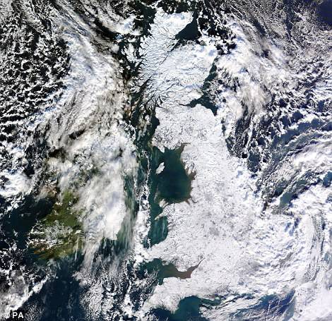
El Niño to Create Extreme Cold in Europe


07C9B4D0000005DC-3234605-Whiteout_A_satellite_image_of_a_snow_covered_UK_in_January_2010-a-80_1442275553867.jpg


Brace yourself for a VERY cold winter: Forecasters warn recent bad weather could be start of most powerful El Nino phenomenon since 1950


Dramatic weather seen across UK yesterday could be start of particularly harsh winter, warn forecasters

They say conditions this year could mirror those of 2009/2010 which saw the coldest January in decades

El Nino phenomenon - which caused snowy winter six years ago - could be the most powerful since 1950

Effect occurs when ocean temperatures rise in eastern Pacific, causing knock-on effects around the globe


Read more: Brace yourself for a VERY cold winter
 
Oh my, the wingnut deniars are going to excommunicate you, Longknife. A hot Pacific causing a cold Europe? Oh, how can heat in one place cause cold in another. They will go on and on. That is how simple minds work.

This is a very interesting and informative thread. Interesting information on the El Nino, revealing posts on the credibility of certain posting here.


http://www.cpc.ncep.noaa.gov/products/analysis_monitoring/lanina/enso_evolution-status-fcsts-web.pdf

The latest weekly SST departures are:
Niño 4 1.0ºC
Niño 3.4 2.3ºC
Niño 3 2.6ºC
Niño 1+2 2.0ºC

Observational data, Westwall, not models. Billy Bob, drop the pants again, your feeble intellect has earned another won.
 
It's called weather. Cyclical weather. The ocean is simply barfing up some of the stored heat that Trenberth left out of his famous "energy" balance diagram.. You know the 93% of the stored heat that was not accounted for..
 

Forum List

Back
Top