KISS THE WEST COAST GOODBYE!

BullKurtz

Gold Member
Sep 13, 2013
7,070
1,236
245
RIGHT BEHIND YOU
While the folks who live in Washington, Oregon, and NorCal go through life trying to ignore the reality of what's coming at them, nobody is raising the warning or sounding the sirens....and that's going to get millions killed. Yep, this time the BIG ONE isn't just a scary movie....it's real and it's REAL BIG! Like a magnitude NINE and a towering tsunami that will level everything in it's path for miles inland.
1_4_36.gif


120114TB_QuakeZone.png


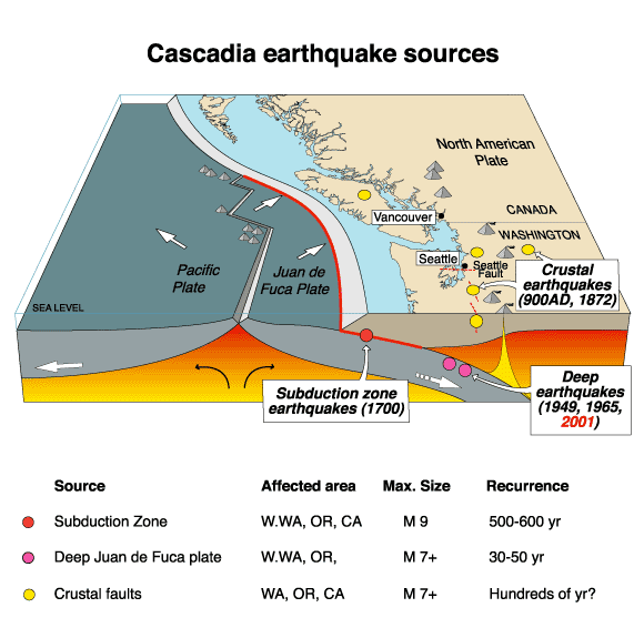
The Cascadia Fault plates are fully LOCKED...they aren't throwing off the normal creaks, groans, and small tremblors that relieve pressure and keep them flexible. This happens once every 300 years and when they break loose.....HOLY SHIT it's gonna be a disaster for the west coast.
ohmy_zps88e14394.png


Study Offshore Fault Where The Big One Originates Eerily Quiet KPLU News for Seattle and the Northwest
 
Actually, yes, it would be a big loss. Not only because of a lot of the valuable farmland that we'd lose, but also because there are quite a few military bases on the West coast, and if we lost all of them, it would have a direct, bad effect on our National Security.
 
Everybody knows about the fault lines, even the dum dums like Bull.
 
Everybody knows about the fault lines, even the dum dums like Bull.

True, but there are geeks on the west coast who actually have jobs listening and monitoring the faults squeaking and shifting. If they are saying it's gotten very quiet lately, that could be a bad sign.

Some scientists are blaming the extraordinary drought in California for tectonic shifting and non-shifting. Ooops, then we be talkin' climate change!

GNSS Charts Drought-Driven Tectonic ‘Uplift’ in Western U.S.
GNSS Charts Drought-Driven Tectonic Uplift in Western U.S. Inside GNSS

August 22, 2014
Precise GNSS measurements have revealed that the severe drought gripping the western United States in recent years is changing the landscape well beyond localized effects of water restrictions and browning lawns, according to scientists at Scripps Institution of Oceanography at the University of California at San Diego.

In an study published in Thursday (August 23, 2014) in the journal Science, researchers have now discovered that the growing, broad-scale loss of water is causing the entire western U.S. to rise up like an uncoiled spring. An article by Kristine Larson, University of Colorado, in the current issue of Inside GNSS describes how GNSS stations established by the National Science Foundation’s Earthscope Plate Boundary Observatory (PBO) are used to measure soil moisture and other physical characteristics of the Earth's surface."""""""
 
this has been building up in understanding since the plate tectonic theory has come around. What we have is three plates, and no real big earthquakes to bleed off the pressure.

The last one happened in 1700. We know it occurred because it let loose a really horrible tsunami......... in Japan.

There has been lots of studies done on it. Land shifted around 11 feet on shore. It was probably worse off shore where it happened. The earthquake in 1906 in California shifted around 4 feet at the focus (pt Reyes CA) for comparison. It will be major when it comes, but there is no way to predict it.

But.... the land will shift, not vanish. land will raise not fall. There will be major Tsunamis. But the fault is offshore about 10 miles. when the clean up comes for it, there will be more land area in the pacific NW, not less. About 10 '. not that major in the scheme of things. Horrible for the folks in Seaside. Not so bad for Portland which is 70 miles away.


If you want to doom and gloom about this area, Mt rainier letting off will be substantially worse. There is only two ways for escape in Seatle, both of which are packed on good days.

And fi you want a real horrible earthquake, Israel is set up for you. There hasn't been an earthquake there in memory. That is also where three fault lines come together (down at the base of Saini) That will be major.
 
Last edited:
Everybody knows about the fault lines, even the dum dums like Bull.

True, but there are geeks on the west coast who actually have jobs listening and monitoring the faults squeaking and shifting. If they are saying it's gotten very quiet lately, that could be a bad sign.

Some scientists are blaming the extraordinary drought in California for tectonic shifting and non-shifting. Ooops, then we be talkin' climate change!

GNSS Charts Drought-Driven Tectonic ‘Uplift’ in Western U.S.
GNSS Charts Drought-Driven Tectonic Uplift in Western U.S. Inside GNSS

August 22, 2014
Precise GNSS measurements have revealed that the severe drought gripping the western United States in recent years is changing the landscape well beyond localized effects of water restrictions and browning lawns, according to scientists at Scripps Institution of Oceanography at the University of California at San Diego.

In an study published in Thursday (August 23, 2014) in the journal Science, researchers have now discovered that the growing, broad-scale loss of water is causing the entire western U.S. to rise up like an uncoiled spring. An article by Kristine Larson, University of Colorado, in the current issue of Inside GNSS describes how GNSS stations established by the National Science Foundation’s Earthscope Plate Boundary Observatory (PBO) are used to measure soil moisture and other physical characteristics of the Earth's surface."""""""

Climate change?????????????????????

Please STFU!!!


:lol: poor Frank
 
Since 1611 I can only find 5 earthquakes that were 9,0...the worst being 9.5 off the coast of Chili that killed thousands....30' tsunami .
 
Last edited:

Forum List

Back
Top