Here comes El Nino!!!

skookerasbil

Platinum Member
Aug 6, 2009
37,963
6,385
1,140
Not the middle of nowhere
Help on the way apparently due to an emerging El Nino.....warmer Pacific water will bring some nice temperatures to weather weary Americans soon >>>

Here comes El Nino; good news for US weather woes

If the El Nino is strong, could have some nice hot temperatures this summer!!!:D:D WIN......goodbye to freezing our asses off!!! I was waiting for the AGW k00ks to start telling us that the Polar Vortex would be dropping in this July due to global warming so this is good news.......you know, you never can know what kind of bogus narrative these shitheads will hit us with next!!
 
Last edited:
If we don't have an 'El niño' year soon the temperature record will fall behind its projections even faster than it already is
 
I see the denialists are taking my advice and lining up their excuses ahead of time. In this case, the planned excuse is "El Nino caused that record warming, so it doesn't count!". Way to think ahead, denialists! That might keep your cult viable a little longer.
 
If we don't have an 'El niño' year soon the temperature record will fall behind its projections even faster than it already is


Shit.....good point.......Im hoping for plenty of nice beach days this summer!! People here in New York this morning.......its like 37 degree's and at the local 7-11, folks were talking about the heat wave.:D Bring that El Nino now.
 
El Nino affecting Uganda and Yemen with severe weather...

Uganda Braces for Strongest El Nino in 20 Years
November 10, 2015 — East Africa is bracing for the impact of El Nino. In Uganda, the government is preparing for massive flooding and landslides and already dealing with a cholera outbreak. People living in slum areas are at particularly high risk.
El Nino, a global climate phenomenon that occurs when surface temperatures in the Pacific Ocean warm and redirect usual wind patterns, produces volatile weather patterns. Godfrey Mujuni, a manager at Uganda's meteorological data center, said rains will continue through what should be the dry season. “Of course, our analysis was based on the evolution of El Nino and we are still monitoring this El Nino because it has not decayed at all it is still there... if El Nino continues to be strong then we expect a somehow wet January and February, which are always dry months here in Uganda for us. In other areas, of course, El Nino is associated with warm and dry conditions, but here in East Africa, El Nino is associated with enhanced rainfall,” said Mujuni.

A7705BD6-CF95-4507-87AD-4CC6EB2480E3_w640_r1_s_cx0_cy13_cw0.jpg

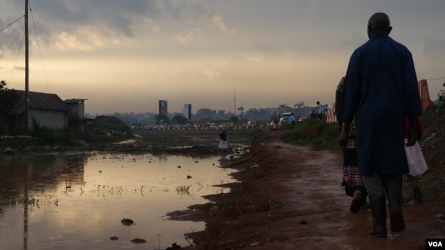
Settlements along drainage pathways often causes flooding and stagnant water along walkways. These large pools of water increase the risk of diseases such as malaria and cholera.​

Heavy rains have already led to a cholera outbreak that has killed six people in western Uganda. And residents in rural mountainous areas prone to mudslides have been asked to vacate their homes. Large rain-induced mudslides in these areas in 2010 and 2012 left hundreds of people dead or missing. In Kampala, a number of wetland systems around the city are responsible for drainage during periods of increased rainfall. However, both legal and illegal construction works have impeded the flow of water. A recent report by the World Bank blames weak regulatory control for the deterioration of the wetlands, saying a lack of oversight has left Kampala's residents at risk. Peter Kaujju, a spokesman with The Kampala Capital City Authority (KCCA) said they are working to combat this problem.

B43963E2-546C-4818-9822-57E34BFEB720_w640_s.jpg

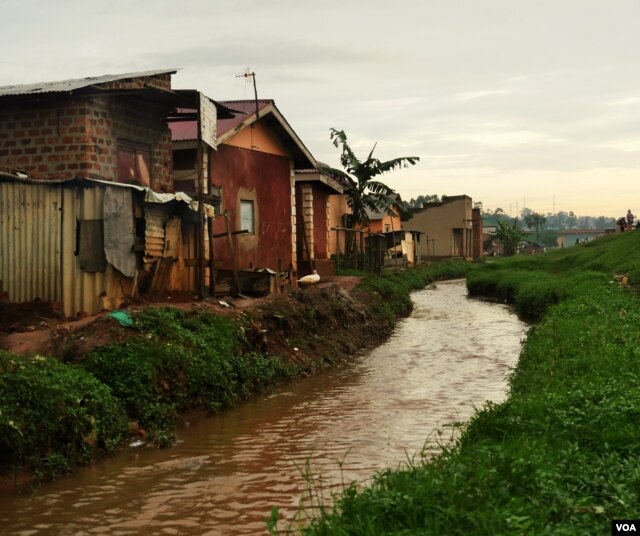
Although drainage channels have been built, homes are often built right up to the edge. Waste dumped in such channels often leads to flooding in low lying homes.​

“A major challenge still exists of people dumping in drainage channels, and at the end of the day they are clogged so there is no smooth flow of water. But we have carried out mass sensitization in these communities. We go to them, we share with them, we tell them what the repercussions are… These are some of the activities that stand in the way of storm water flow,” said Kaujju. He said they have also razed some structures in wetland areas and along drainage channels. Uganda has increased disaster management teams both in Kampala and around the country. Yet with rainfall expected to increase in the coming months, even preventative measures could leave some of the nation’s poorest residents with nowhere to go.

Uganda Braces for Strongest El Nino in 20 Years

See also:

Yemen Cyclone Kills 13 on Socotra Island, Hits Mainland
November 10, 2015 — Winds and rain from the second rare cyclone to hit Yemen in two weeks have killed 13 people, including three children, on Yemen's Socotra island, the fisheries minister said on Tuesday.
Cyclone Megh slammed into Socotra on Sunday with Category 4 hurricane-force winds, and arrived on the Yemeni mainland's southern shore near the port city of Aden on Tuesday. Fisheries Minister Fahd Kafayen said that three fishermen were also missing on the island, according to his Facebook page. The storm injured an estimated 60 people and damaged houses, the main power station and hospital on Socotra, the U.N. humanitarian office OCHA said. It is an area of the Arabian Sea where cyclones were virtually unheard of before this month, but two such storms have battered Socotra within the past two weeks.

AD3138C5-95A0-4A85-95C2-368BB1BAE345_w640_r1_s_cx0_cy1_cw0.jpg

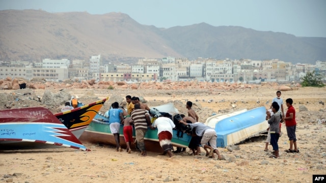
Yemeni fishermen push a boat to shore as they prepare for tropical cyclone Megh, in the southern city of Mukalla in Yemen's Hadramawt province​

The lack of experience with cyclones means that Yemen, which has been ravaged by war this year, is ill-equipped to deal with floods and high winds. The latest storm weakened significantly after reaching mainland Yemen's mountainous terrain on Tuesday, about 70 km (40 miles) east of the port of Aden, a spokeswoman for the World Meteorological Organization (WMO) said. The Geneva-based organization said a third storm could be brewing in the Arabian Sea, but spokeswoman Clare Nullis said those winds were expected to abate. The WMO said the highly unusual strike by two cyclones in a week was due to the "Indian Ocean dipole," a weather phenomenon similar to a regional "El Nino" effect caused by unusually warm surface water in the Arabian Sea.

Megh came a week after Cyclone Chapala killed 11 Yemenis on Socotra and the mainland, dumping nearly a decade of average annual rainfall on the impoverished country in just two days. More than a third of Socotra's population, 18,000 people, were displaced by that cyclone. Megh tracked further south than Chapala and, earlier, brought three times the annual rainfall to parts of Puntland in Somalia, threatening flash floods around the tip of the Horn of Africa, the U.N. Food and Agriculture Organization said. Aid efforts in Yemen are hampered by the seven-month war between a Shi'ite Muslim militia based in the capital Sanaa in the north of the country and forces loyal to the exiled government, backed by Gulf Arab states.

Yemen Cyclone Kills 13 on Socotra Island, Hits Mainland
 
El Nino is supposed to be sitting of the Pacific coast bringing us warmer drier conditions this fall and winter. We went from a screaming hot summer immediately into full blown fall with so much wind it knocked out our power for five days in October. Now it hasn't hardly stopped raining. Today we had 45 mph winds, projected to get up to 60 mph and dump two inches of rain in the next four days. We usually don't have enough wind here to sail. When it does rain, it usually drizzles. These kind of winds and that much measurable rain is unusual to say the least. We can see new snow in the mountains, and the rivers are near flood stage. Bring on El Niño, please.
 
I am much enjoying that fact that the West Coast is getting a lot of rain. We need it, as well as a lot of snow in the mountains. As for the rest, the South is getting the rain that the meteorologists predicted.
 
If we don't have an 'El niño' year soon the temperature record will fall behind its projections even faster than it already is
Well fellow, you are another failure at prognostication. 2015 looks like it will go down as the warmest year by a long ways.
 
If we don't have an 'El niño' year soon the temperature record will fall behind its projections even faster than it already is
Well fellow, you are another failure at prognostication. 2015 looks like it will go down as the warmest year by a long ways.
naw.


2015 will go down with the most model adjustments made in a year. There you go!!!!
 
Seasonal storms bring A year’s worth of rain in Qatar...

A year’s worth of rain in Qatar as floods hit Saudi Arabia
Tuesday, Nov. 24, 2015 — A year’s worth of rain deluged parts of Qatar on Wednesday as seasonal storms moving through Saudi Arabia flooded streets in a city northwest of the capital, Riyadh. The storm system clouded skies over parts of the Arabian Peninsula, but struck Doha, the capital of Qatar, particularly hard.
At Hamad International Airport in Doha, the home of Qatar Airways, at least 79.5 millimeters (3.13 inches) of rain fell, according to the Qatar Meteorology Department. Typically, the hot, desert country sees around 50 millimeters (1.97 inches) of rain in a year. The rainwater flooded streets and shut down some stores and malls in Doha. Local media reported some schools and daycare centers closed early because of the downpour. At 4 p.m., the temperature was a cool 24 degrees Celsius (75.2 degrees Fahrenheit).

MideastWeather-02801.jpg

In Saudi Arabia, the state-run Saudi Press Agency said heavy rains and flooding struck the city of Buraydah, some 320 kilometers (200 miles) northwest of Riyadh, as well as the surrounding Qassem province. Saudi civil defense authorities posted photos online of their officers rescuing people by boat. Other social media images showed rushing water eating away at roads and cars stuck in the floodwaters.

Normally parched countries on the Arabian Peninsula have seen rain in recent days as the seasons change across the Gulf. In Dubai, clouds darkened the skies and rain fell across parts of the city and elsewhere in the United Arab Emirates. At Dubai’s Burj Khalifa, the world’s tallest building, the temperature stood at 22 C (71.6 F) at 4 p.m.

A year's worth of rain in Qatar as floods hit Saudi Arabia

Monsoonal rains are not uncommon and they go in cycles. Just like every other place on earth...
 
El Nino affecting Uganda and Yemen with severe weather...

Uganda Braces for Strongest El Nino in 20 Years
November 10, 2015 — East Africa is bracing for the impact of El Nino. In Uganda, the government is preparing for massive flooding and landslides and already dealing with a cholera outbreak. People living in slum areas are at particularly high risk.
El Nino, a global climate phenomenon that occurs when surface temperatures in the Pacific Ocean warm and redirect usual wind patterns, produces volatile weather patterns. Godfrey Mujuni, a manager at Uganda's meteorological data center, said rains will continue through what should be the dry season. “Of course, our analysis was based on the evolution of El Nino and we are still monitoring this El Nino because it has not decayed at all it is still there... if El Nino continues to be strong then we expect a somehow wet January and February, which are always dry months here in Uganda for us. In other areas, of course, El Nino is associated with warm and dry conditions, but here in East Africa, El Nino is associated with enhanced rainfall,” said Mujuni.

A7705BD6-CF95-4507-87AD-4CC6EB2480E3_w640_r1_s_cx0_cy13_cw0.jpg

Settlements along drainage pathways often causes flooding and stagnant water along walkways. These large pools of water increase the risk of diseases such as malaria and cholera.​

Heavy rains have already led to a cholera outbreak that has killed six people in western Uganda. And residents in rural mountainous areas prone to mudslides have been asked to vacate their homes. Large rain-induced mudslides in these areas in 2010 and 2012 left hundreds of people dead or missing. In Kampala, a number of wetland systems around the city are responsible for drainage during periods of increased rainfall. However, both legal and illegal construction works have impeded the flow of water. A recent report by the World Bank blames weak regulatory control for the deterioration of the wetlands, saying a lack of oversight has left Kampala's residents at risk. Peter Kaujju, a spokesman with The Kampala Capital City Authority (KCCA) said they are working to combat this problem.

B43963E2-546C-4818-9822-57E34BFEB720_w640_s.jpg

Although drainage channels have been built, homes are often built right up to the edge. Waste dumped in such channels often leads to flooding in low lying homes.​

“A major challenge still exists of people dumping in drainage channels, and at the end of the day they are clogged so there is no smooth flow of water. But we have carried out mass sensitization in these communities. We go to them, we share with them, we tell them what the repercussions are… These are some of the activities that stand in the way of storm water flow,” said Kaujju. He said they have also razed some structures in wetland areas and along drainage channels. Uganda has increased disaster management teams both in Kampala and around the country. Yet with rainfall expected to increase in the coming months, even preventative measures could leave some of the nation’s poorest residents with nowhere to go.

Uganda Braces for Strongest El Nino in 20 Years

See also:

Yemen Cyclone Kills 13 on Socotra Island, Hits Mainland
November 10, 2015 — Winds and rain from the second rare cyclone to hit Yemen in two weeks have killed 13 people, including three children, on Yemen's Socotra island, the fisheries minister said on Tuesday.
Cyclone Megh slammed into Socotra on Sunday with Category 4 hurricane-force winds, and arrived on the Yemeni mainland's southern shore near the port city of Aden on Tuesday. Fisheries Minister Fahd Kafayen said that three fishermen were also missing on the island, according to his Facebook page. The storm injured an estimated 60 people and damaged houses, the main power station and hospital on Socotra, the U.N. humanitarian office OCHA said. It is an area of the Arabian Sea where cyclones were virtually unheard of before this month, but two such storms have battered Socotra within the past two weeks.

AD3138C5-95A0-4A85-95C2-368BB1BAE345_w640_r1_s_cx0_cy1_cw0.jpg

Yemeni fishermen push a boat to shore as they prepare for tropical cyclone Megh, in the southern city of Mukalla in Yemen's Hadramawt province​

The lack of experience with cyclones means that Yemen, which has been ravaged by war this year, is ill-equipped to deal with floods and high winds. The latest storm weakened significantly after reaching mainland Yemen's mountainous terrain on Tuesday, about 70 km (40 miles) east of the port of Aden, a spokeswoman for the World Meteorological Organization (WMO) said. The Geneva-based organization said a third storm could be brewing in the Arabian Sea, but spokeswoman Clare Nullis said those winds were expected to abate. The WMO said the highly unusual strike by two cyclones in a week was due to the "Indian Ocean dipole," a weather phenomenon similar to a regional "El Nino" effect caused by unusually warm surface water in the Arabian Sea.

Megh came a week after Cyclone Chapala killed 11 Yemenis on Socotra and the mainland, dumping nearly a decade of average annual rainfall on the impoverished country in just two days. More than a third of Socotra's population, 18,000 people, were displaced by that cyclone. Megh tracked further south than Chapala and, earlier, brought three times the annual rainfall to parts of Puntland in Somalia, threatening flash floods around the tip of the Horn of Africa, the U.N. Food and Agriculture Organization said. Aid efforts in Yemen are hampered by the seven-month war between a Shi'ite Muslim militia based in the capital Sanaa in the north of the country and forces loyal to the exiled government, backed by Gulf Arab states.

Yemen Cyclone Kills 13 on Socotra Island, Hits Mainland

You guys are too funny: You put this crap up over and over again but fail to check the facts of their regional climates. Guess what, these happen cyclically and are NOT UNCOMMON in the regions history.

Tell me, What caused the canyons to be created in California? what created valley bottom soils to be mixed with organic matter from the mountains and made them fertile for farming?

These wild ass straw men that the LSM is promoting are crap and easily debunked. If they were truly journalists they would check the facts before publishing this crap!
 
No, you dumb ass, it is not at all uncommon in the regions history. Occurs almost every time there is an El Nino. And now we have a super El Nino. So, they are doing the intelligent thing and making preparations for the effects of the storms that the El Nino will more than likely bring.
 
I see the denialists are taking my advice and lining up their excuses ahead of time. In this case, the planned excuse is "El Nino caused that record warming, so it doesn't count!". Way to think ahead, denialists! That might keep your cult viable a little longer.

clip_image006_thumb1.jpg


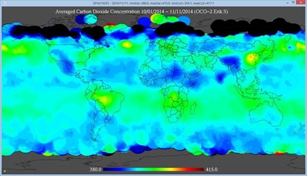
CO2 satellite called to say your theory fails
 
No, you dumb ass, it is not at all uncommon in the regions history. Occurs almost every time there is an El Nino. And now we have a super El Nino. So, they are doing the intelligent thing and making preparations for the effects of the storms that the El Nino will more than likely bring.

LOL!!!

Did the Super El Nino eat the Pacific Blob?
 
No, you dumb ass, it is not at all uncommon in the regions history. Occurs almost every time there is an El Nino. And now we have a super El Nino. So, they are doing the intelligent thing and making preparations for the effects of the storms that the El Nino will more than likely bring.
Yeah right. El Niño is now everything right?
 
Still proving your two digit IQ there, jc? When we are warming, the El Nino's become more intense. That is exactly what we are seeing. And the results of the increase in intensity, are storms that are more intense. More precipitation, more wind. Again, we have seen that this year. Since the maximum effect usually occur about three months after the El Nino reaches peak intensity, we are looking at February and March for this El Nino.
 
Still proving your two digit IQ there, jc? When we are warming, the El Nino's become more intense. That is exactly what we are seeing. And the results of the increase in intensity, are storms that are more intense. More precipitation, more wind. Again, we have seen that this year. Since the maximum effect usually occur about three months after the El Nino reaches peak intensity, we are looking at February and March for this El Nino.
Where are we seeing warming? Chicago?
 
I see the denialists are taking my advice and lining up their excuses ahead of time. In this case, the planned excuse is "El Nino caused that record warming, so it doesn't count!". Way to think ahead, denialists! That might keep your cult viable a little longer.

clip_image006_thumb1.jpg


CO2 satellite called to say your theory fails
No, Frankie Boy, your eyeballs and intellect fail. Note the amount over China, and west of China. Same for the East Coast of the US. Now look at Europe. Not that the primary amount is somewhat east of France, Germany and Great Britain. Note also in the Northern Hemisphere, we have Westerly winds. Now look at the hot spot in South America. West of Brazil and Argentina. In the Southern Hemisphere, they have Easterly winds. Pretty well explains the distribution of the CO2. And it is as expected, and primarily due to human sources.
 

Forum List

Back
Top