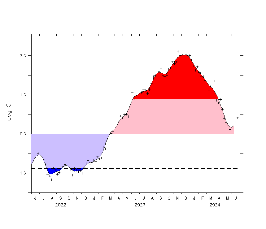
Drifting back into a nina? back down to -.4c!

More La Nina would be bad news for Texas and the southwest USA, because it means the ongoing drought there ongoes even longer.

Add to that the aquifiers going dry in the southern plains, and a lot of agricultural land is being abandoned for lack of water.

On the bright side, aquifiers can't be contaminated by pipelines and fracking if they no longer exist.
 
El Nino being replaced by La Nina...
icon_omg.gif

La Niña Threatens to Bring Drought to East Africa
June 22, 2016 - The Pacific Ocean is in the midst of an El Niño weather phenomenon that warms the surface of the water, but climate scientists say not for much longer. It is about to be replaced by its sister, La Niña, which comes around every two to five years and cools the surface of the central and eastern Pacific Ocean.
United States Geological Survey (USGS) research scientist Dr. Chris Funk says that, as strange as it sounds, both weather systems can affect long-term weather patterns in a landlocked country half a world away. If La Niña bumps her brother out of the way, says Funk, “it is quite possible that we might have drought in the southern part of Ethiopia in the fall of next year.” How is that possible? Think of the weather as a line of stacked dominos — when one falls over, all the rest follow. In this case, La Niña is that first domino, and as it changes the weather in the Pacific, those changes cascade across the entire planet.

EE0AD675-6E35-434E-B11C-9B61BE41B07B_w640_r1_s_cx0_cy7_cw0.jpg

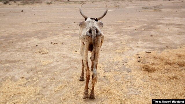
An emaciated cow walks in an open field in Gelcha village, one of the drought-stricken areas of Oromia region, in Ethiopia​

Right now, El Niño is part of the reason the northern region of Ethiopia is experiencing its worst drought in decades. But as La Niña takes its place, Funk says those rainfall deficits are likely to move into the southern parts of Ethiopia, extending into the Horn of Africa. “There are two rainy seasons in the equatorial part of east Africa,” Funk said. “They get rain in the fall — October, November and December — and there is another rainy season in March, April and May. So one of the dangers of La Niña is it can make both of these seasons perform very poorly. That is what happened in 2010 and 2011. So there is concern from a food security perspective [that] we might have two poor rainy seasons in a row.”

60567AAC-F86E-495A-8DC6-BF47489F8F06_w640_s.jpg

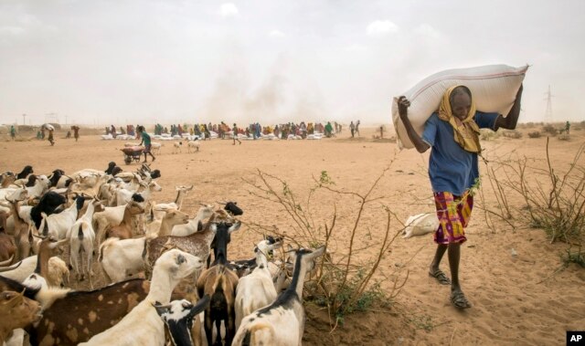
Drought-stricken Ethiopians receive aid in the Shinile Zone of Ethiopia near the border with Somalia​

Back-to-back droughts in Kenya and Somalia, or a March-June drought in Ethiopia, could cause food and water shortages, hurt hydro-power stations and worsen farming conditions. Funk's team is working on ways to prepare for the threat of hard times. The group is urging the population to brace for drought-related monetary loss, but also is using high-tech equipment to help farmers and livestock managers find water. While it may not be possible to stop a drought, scientists are getting better at predicting it and helping those most affected prepare for the worst.

La Niña Threatens to Bring Drought to East Africa
 
La Nina may make drought worse in Africa...

UN worried La Nina will worsen 'dire' drought in Somalia
Friday 2nd September, 2016 - The La Nina weather phenomenon is likely to worsen drought and hunger in Somalia, especially in the north where many people and their animals are migrating in search of water after four failed rainy seasons, the United Nations said on Thursday.
La Nina, characterised by unusually cold temperatures in the equatorial Pacific Ocean, is predicted to bring further hardship to swathes of east and southern Africa already hit by the El Nino weather phenomenon. El Nino, a warming of the Pacific Ocean, brought severe drought to northern parts of Somalia, like Puntland and Somaliland, and floods to southern and central areas. "The situation could further worsen in the likelihood of a La Niña event," the United Nations (U.N.) Office for the Coordination of Humanitarian Affairs said in its latest bulletin. "The outlook for Puntland compounds an already dire situation with the food security situation for southern and central Somalia also increasingly worrying."

Somalia's 2011 famine, in which 260,000 people died, was partly the result of a significant La Nina following El Nino. Four out of 10 Somalis - some 4.7 million people - already need humanitarian aid, the United Nations said, amid conflict between the Islamist militant group al Shabaab and the African Union-backed government. The Famine Early Warning Systems Network (FEWSNET) predicts La Nina will last throughout Somalia's October to January short rainy season, known as the Deyr.

This could increase hunger and migration, the United Nations said, as poor rains have already destroyed crops and reduced the opportunity for people to earn money as farm labourers. The August harvest is likely to be 30 percent to 50 percent below average in southern and central Somalia due to poor Gu rains between April and July, the United Nations said. "The food security situation in southern and central and northeastern parts of Somalia is expected to deteriorate in the coming months with more people facing acute food insecurity," it said.

UN worried La Nina will worsen 'dire' drought in Somalia
 
nino34_short.gif

We've been at -0.74 deg C for over 5 weeks now.....

I was wondering why there were often such large numeric discrepancies between you and others on ENSO parameters. I searched for the source of your graphic here. Turns out it comes from Global Ocean Observing Systems (GOOS). It turned out they also had data graphics on sea level rise, coral and arctic ice. Unfortunately, the site seems to be a bit of a ghost town. The sea level page makes note of a level drop in 2010 as if it were fresh news and shows the standard UC graphic from mid 2013. It does state that UC is a good source. The corals page is up to date, but the Arctic ice page simply does not function.

I think you might look for a more reliable source Bob.
 
Should be a mild winter...
confused.gif

Here Comes La Nina, El Nino's Flip Side, but it Will Be Weak
November 09, 2017 | WASHINGTON — La Nina, the cool flip side to El Nino, is returning for a second straight winter, forecasters said Thursday.
The National Oceanic and Atmospheric Administration said a weak La Nina has formed and is expected to stick around for several months. La Nina is a natural cooling of parts of the Pacific that alters weather patterns around the globe. La Nina typically brings drier conditions to the U.S. South and wetter weather to the Pacific Northwest and western Canada. Indonesia, the Philippines, northeastern South America and South Africa often see more rain during La Nina winters.

B0858953-FB2F-43E5-BC4A-E13EC597A58E_w1023_r1_s.jpg

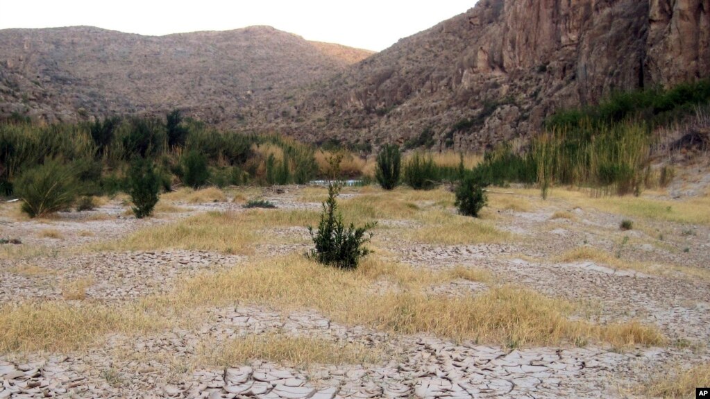
Dry cracked mud is seen along the banks of the Rio Grande at Big Bend National Park in Texas during one of the strongest La Nina years on record, March 25, 2011. The National Oceanic and Atmospheric Administration said Thursday, Nov. 9, 2017 that a weak La Nina has formed and is expected to stick around for several months.​

Last year's La Nina was unusually brief, forming in November and gone by February. This one should hang around through the end of winter. While it may last a bit longer than last year's La Nina, it should be just as weak, said Mike Halpert, deputy director of NOAA's Climate Prediction Center. Texas A&M University agricultural economist Bruce McCarl said La Nina years are often bad for Texas and the surrounding region. U.S. production of most crops - except corn - generally goes down in La Nina years, according to research by McCarl.

The last major La Nina several years ago caused major crop damage and Texas suffered a devastating drought, McCall said. On average, La Nina years hurt U.S. and China gross domestic product about 0.3 percentage points, but lead to growth in India, New Zealand and South Africa, according to Kamiar Mohaddes, a University of Cambridge economist. Because La Nina shifts storm tracks, it often brings more snow in the Ohio and Tennessee Valleys. "Typically La Nina is not a big snow year in the mid-Atlantic," Halpert said. "You have a better chance up in New England."

Here Comes La Nina, El Nino's Flip Side, but it Will Be Weak
We will see....

Fluid circulations are indicating that a moderate to cold La Niña will persist. The deep water heat is gone...those pools are now cold..
 
Silly Billy is predicting ENSO again. LOL

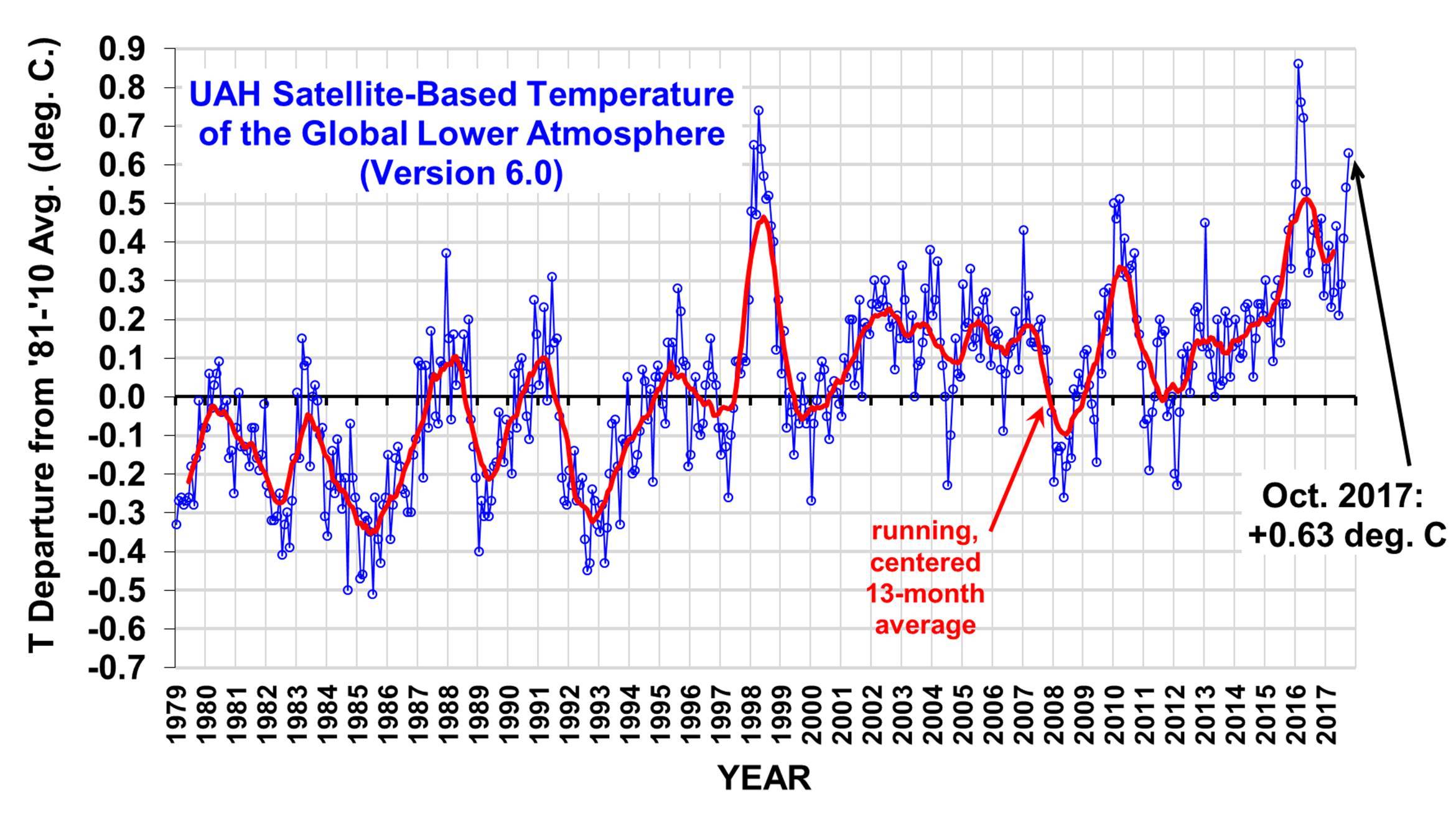
UAH_LT_1979_thru_October_2017_v6-1.jpg

http://www.drroyspencer.com/wp-content/uploads/UAH_LT_1979_thru_October_2017_v6-1.jpg

Quite an anomaly for an incipient La Nina.
Such ignorance...Its funny that Dr Spencer is now reviewing the infilling algorithm because it is 0.4 deg C to high when compared with Empirical Evidence. Your going to be sadly disappointed when the corrections are finally made..

The air aloft has already cooled...

103 year record cold low for New York City set
 

Forum List

Back
Top