remember the Y2K problem with GISS? here is the timeline for those that are unfamiliar with the story.
NASA: "Hide this after Jim checks it"
"
At 10:23 Hansen complained that he is being “besieged” by emails (either the FOI is incomplete or, in Hansen-world, a few inquiries constitute a siege) and decided to “do something”:
I am being besieged by emails and calls about this, so we need to do something promptly as there will be stories written today for publication tomorrow… By the way, Makiko, do you remember if we ever make any statement about how different years ranked for the U.S. temperatures? There are several demands that we issue a press release correcting our wrong results and declaring that 1934 is now the warmest year on record in the US and also that 4 of the 10 warmest years were in the 1930s and only 3 in the last 10 years.
In the late morning, Ruedy answered Leslie McCarthy (apparently the PR person) sycophantically describing Hansen’s tirade to Revkin as answering in the “clearest and most beautiful way”, before making various accusations against me:
Andy Revkin asked the same question and Jim’s answer below says it all in the clearest and most beautiful way… The blog you attached is a prime example of what gives bloggers a really bad name; somebody with no idea what he is talking about is spouting absolute nonsense, making no distinction between what is essential (the facts he conveniently omits) and what is pure noise (which he is concentrating on exclusively). ..
He finds it astounding that the years 1934 and 1998 reversed ranks, not remembering that the corrections only affected years 2000-2006, hence there is no possible connection there. By speaking of warmest year (rather than warmest year in the US time record), he successfully deceived people like Mark Taylor.”
Just before noon Aug 10, Hansen again complains about being “besieged”, but this time with a knot in his stomach as he’s just been told that the earlier results have been “thrown away”, making a before and after comparison impossible. Hansen pleads for his subordinates to retrace their steps or they will “never live this down” and sensibly recommends that they save their results at least once a year in the future:
I am being besieged by these… The appropriate response is to show the curves for U.S. and global temperatures before and after McIntyre’s correction. Makiko doubts that his is possible because the earlier result has been ‘thrown away’. We will never live this down if we give such a statement. It must be possible to reconstruct the “before” result. Unfortunately this needs to be done soon as there are various writers with deadlines this afternoon. .. By the way, I think that we should save the results of the analyses at least once a year, so we will have a record of how they change.
"
hahahahaha. read the whole thing, it is very enlightening. the FOI emails flying back and forth between the Real Climate Team are an absolute hoot!
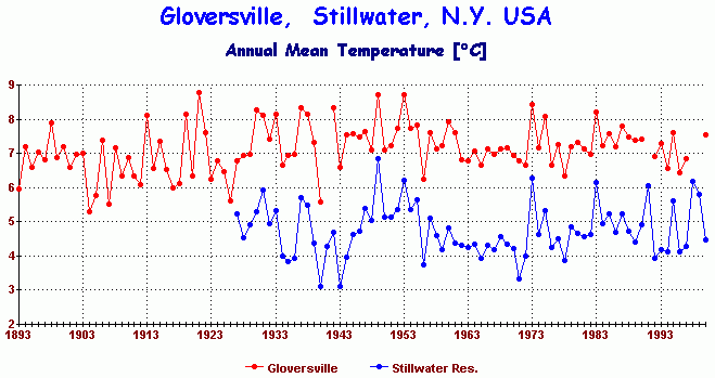
I especially laughed at Hansen saying that 1934 and 1998 couldnt have changed places as the warmest year because the mistake only affected the years after Y2K. for people who dont know the story, GISS changed all the pre-Y2K years and left the post-Y2K years alone. why? who knows.