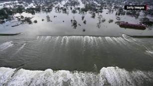
The destruction left by Hurricane Harvey and its historic rainfall, powerful Hurricane Irma is rapidly intensifying in the open Atlantic and poses a major threat to the Caribbean and potentially to the United States next week.
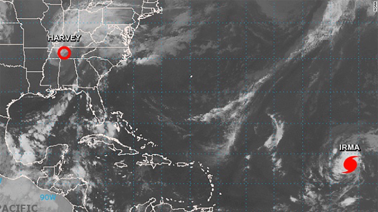
Satellite image taken at 8 a.m. ET Friday shows Hurricane Irma in the eastern Atlantic
With the storm still five days away from the outermost Caribbean islands and at least a week away from any potential US impacts, there is still a lot of uncertainty about where it will go.
The range of possibilities presented by the forecast models more than a week out literally spreads from Mexico to Canada -- and everywhere in between.
Irma was designated a tropical storm Wednesday morning, and by Thursday afternoon, it had strengthened into a large Category 3 hurricane, with winds of 115 mph.
Hurricane Irma is forecast to continue to strengthen as it moves westward over the next five days, and the official forecast from the National Hurricane Center puts a dangerous Category 4 Hurricane Irma on the doorstep of the Caribbean by the end of the five-day forecast on Wednesday.
A strong high-pressure ridge to the north of Irma, over the Atlantic, is steering the storm to the west and limiting the wind shear in the upper levels of the atmosphere, which has allowed the storm to grow so quickly. Wind shear is like hurricane kryptonite, and prevents storms from forming or gaining strength.
Unfortunately, Irma will remain in a low-shear environment for the next several days, so there isn't much hope that Irma will weaken any time soon.
There is considerable confidence that Hurricane Irma will track to the west through the weekend and then take a slight jog to the southwest early next week in response "to a building ridge (of high pressure) over the central Atlantic."
From there, the forecast becomes a lot less clear, with some major differences among some of the key models meteorologists use to forecast hurricanes. The differences are so drastic that one prediction has Irma sliding harmlessly back out to sea, while in another, it makes multiple disastrous landfalls in the Caribbean and likely hits the United States after that.
Dueling prediction models
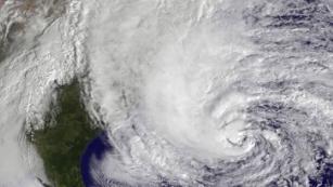
The European model, or ECMWF, and the American GFS model have had some notable showdowns before, most notably with Hurricane Sandy.
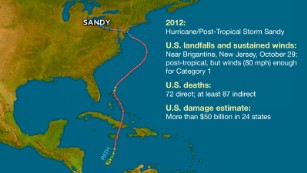
With Sandy, the ECMWF correctly predicted a landfall in the Northeast nearly a week ahead, while the GFS continually kept the storm offshore in what became a major black eye for the US weather-modeling industry. There have been other examples in which the GFS model has outperformed its European counterpart, such as with a few major snowstorms in the Northeast.
Right now, the GFS has Irma taking a more northerly track that curves to the north before it reaches the Caribbean, thus making a US landfall much less likely.
The European model keeps the storm tracking further west, nearing the Bahamas by the end of next week.
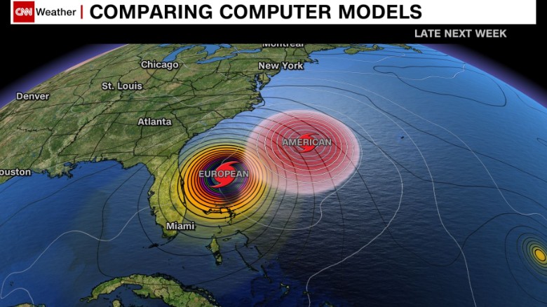
European vs American weather models
"The ECMWF sees a much stronger ridge or Bermuda High (than the GFS) which forces Irma west, whereas the GFS has a weaker ridge and a more rightward, parabolic track," said Ryan Maue, a meteorologist with WeatherBell Analytics.
"The prospects for major impacts anywhere from Cuba to Carolinas is concerning for this very reliable model," Maue said.
Irma is still more than 1,700 miles east of the Leeward Islands, and any impacts from the storm wouldn't be felt until Tuesday or Wednesday for the Leeward Islands and Puerto Rico.
The forecast picture should become clearer after the weekend.
Bottom line: Hurricane Irma is already a powerful hurricane and looks to only become more so. Those with interests in the Caribbean and southeast US coast should pay close attention to the forecast.
HURRICANE IRMA
Hurricane Irma becomes Category 3 storm
Powerful Hurricane Irma could be next weather disaster - CNN
Satellite image taken at 8 a.m. ET Friday shows Hurricane Irma in the eastern Atlantic
With the storm still five days away from the outermost Caribbean islands and at least a week away from any potential US impacts, there is still a lot of uncertainty about where it will go.
The range of possibilities presented by the forecast models more than a week out literally spreads from Mexico to Canada -- and everywhere in between.
Irma was designated a tropical storm Wednesday morning, and by Thursday afternoon, it had strengthened into a large Category 3 hurricane, with winds of 115 mph.
Hurricane Irma is forecast to continue to strengthen as it moves westward over the next five days, and the official forecast from the National Hurricane Center puts a dangerous Category 4 Hurricane Irma on the doorstep of the Caribbean by the end of the five-day forecast on Wednesday.
A strong high-pressure ridge to the north of Irma, over the Atlantic, is steering the storm to the west and limiting the wind shear in the upper levels of the atmosphere, which has allowed the storm to grow so quickly. Wind shear is like hurricane kryptonite, and prevents storms from forming or gaining strength.
Unfortunately, Irma will remain in a low-shear environment for the next several days, so there isn't much hope that Irma will weaken any time soon.
There is considerable confidence that Hurricane Irma will track to the west through the weekend and then take a slight jog to the southwest early next week in response "to a building ridge (of high pressure) over the central Atlantic."
From there, the forecast becomes a lot less clear, with some major differences among some of the key models meteorologists use to forecast hurricanes. The differences are so drastic that one prediction has Irma sliding harmlessly back out to sea, while in another, it makes multiple disastrous landfalls in the Caribbean and likely hits the United States after that.
Dueling prediction models
The European model, or ECMWF, and the American GFS model have had some notable showdowns before, most notably with Hurricane Sandy.
With Sandy, the ECMWF correctly predicted a landfall in the Northeast nearly a week ahead, while the GFS continually kept the storm offshore in what became a major black eye for the US weather-modeling industry. There have been other examples in which the GFS model has outperformed its European counterpart, such as with a few major snowstorms in the Northeast.
Right now, the GFS has Irma taking a more northerly track that curves to the north before it reaches the Caribbean, thus making a US landfall much less likely.
The European model keeps the storm tracking further west, nearing the Bahamas by the end of next week.
European vs American weather models
"The ECMWF sees a much stronger ridge or Bermuda High (than the GFS) which forces Irma west, whereas the GFS has a weaker ridge and a more rightward, parabolic track," said Ryan Maue, a meteorologist with WeatherBell Analytics.
"The prospects for major impacts anywhere from Cuba to Carolinas is concerning for this very reliable model," Maue said.
Irma is still more than 1,700 miles east of the Leeward Islands, and any impacts from the storm wouldn't be felt until Tuesday or Wednesday for the Leeward Islands and Puerto Rico.
The forecast picture should become clearer after the weekend.
Bottom line: Hurricane Irma is already a powerful hurricane and looks to only become more so. Those with interests in the Caribbean and southeast US coast should pay close attention to the forecast.
HURRICANE IRMA
Hurricane Irma becomes Category 3 storm
Powerful Hurricane Irma could be next weather disaster - CNN


