On a NASA page intended to spread
climate alarmism (
Climate Change: Vital Signs of the Planet: Sea Level), NASA’s own data reveal that
worldwide ocean levels have been falling for nearly two years, dropping from a variation of roughly 87.5mm to below 85mm.
This data clearly contradicts the false narrative of rapid, never-ending rising ocean levels that flood continents and drown cities.The narrative is climate alarmists key element of the climate change fear mongering fiction that’s used to
scare gullible youth into making Al Gore rich.
NASA Confirms Falling Sea Levels For Two Years Amidst Media Blackout
LOL Look at the graph, several places where the rise levels off, or even declines, then continues on it's upward course. You, and the fellow that wrote the article are full of shit. The graph demonstrates that.
Yes, well in order for the graph to go down, land based glaciers would have to be growing, thus removing water from the seas. Of course you and your ilk vehemently deny that is happening, so you have to admit one is a lie or the other.
75 of the old glacial areas again have multiyear ice on them right here in the Good Old USA.. and just in the last three years.... They are indeed growing again..
More stinky facts from the ample ass of Silly Billy. LOL
Bachfallenferner, Austria: 2017 Illustrates Why Glacier is Forecast to Not Survive - From a Glacier's Perspective
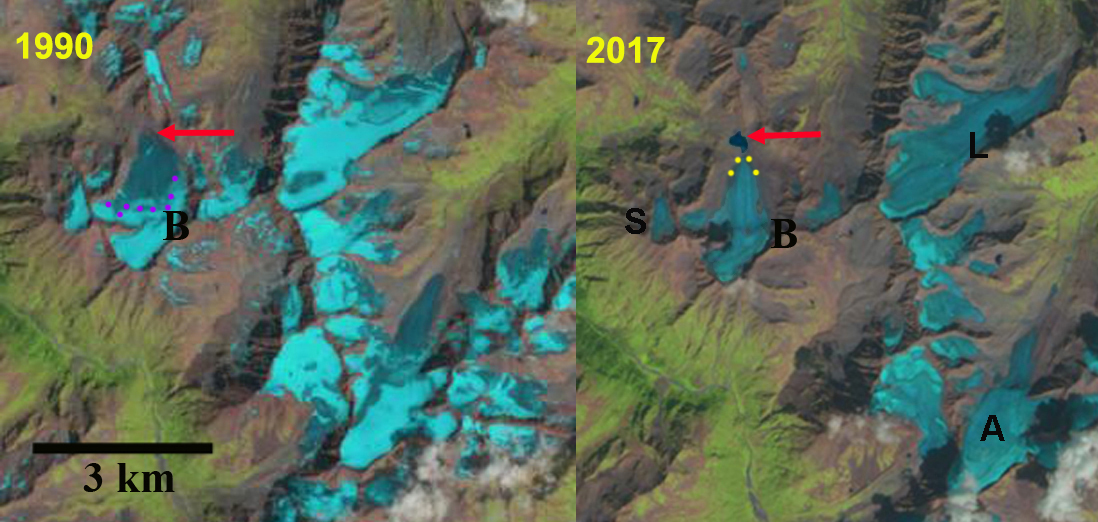
Comparison of Bachfallenferner (B) in Landsat images from 1990 and 2017. The red arrow indicates the 1990 terminus position and yellow dots the 2017 terminus. Note there is no retained snowcover in 2017 and a new lake has formed due to retreat. Other glaciers that lost all snowcover in 2017 L=Lisenser, A=Alpeiner and S=Sauischbachferner
Bachfallenferner is in the Stubaier Alpen, Austria. The glacier terminus fluctuations are examined annually and reported by the Austrian Alpine Club
Fischer (2016) and
Fischer (2017), with all 11 glacier in the Stubaier area retreating in 2015 and 2016.
Fischer and Kuhn (2012) surveyed the thickness of 64 alpine glaciers in Austria including Bachfallenferner, with a goal of determining volume. They found in 2000 the glacier had an area of 2.08 square kilometers, with an average thickness of 41 m yielding a volume of .085 cubic kilometers.
In 1990 Bachfallenferner ended on an outwash Plain at 2700 m. The glacier was 2350 m long in 1990 with a width of 1100 m at its mid-point. By 1999 a small sublacial lake has formed at the terminus, the lower 0.8 kilometer of the glacier is uncrevassed and relatively stagnant. In 1999 the snowcover the retained snowcover in late August covers 30% of the glacier. In 2015 the glacier retreat has led to the formation of a proglacial lake that is 275 m across. The glacier in late August is only 10-15% snowcovered. By 2017 the glacier has retreated 400 m from its 1990 location including 60 m in 2015 and 2016. More importantly the glacier by late August has lost all of its snowcover, as essentially have some of its neighbors: L=Lisenser, A=Alpeiner and S=Sauischbachferner. A glacier that does not consistently retain snowcover cannot survive (
Pelto, 2010). The glacier is now less than 2 km long and at the 1990 mid-point is 800 m wide. Lateral recession in the lower 1 km of the glacier is similar to the rate of terminus recession. The maximum ice thickness in 2000 was 97 m
Fischer and Kuhn (2012), which is likely to have lost no more than a meter per year, hence there is still some comparatively thick ice. The
Stubaier Alpen has experienced substantial retreat in the last 30 years as have all Austrian Glaciers (
Fischer et al.,2015). Bachfallenferner is larger than most of the Austrian glaciers that are currently disappearing such as
Mittlerer Guslarferner.
 And the glaciers in the US are doing exactly the same. Lying about that will not add one inch to the terminus.


