U.S. Geological Survey: Warmer Springs Causing Loss Of Snow Cover Throughout The Rock

ScienceRocks

Democrat all the way!
Mar 16, 2010
59,455
6,793
1,900
The Good insane United states of America
U.S. Geological Survey: Warmer Springs Causing Loss Of Snow Cover Throughout The Rocky Mountains

By Joe Romm on May 16, 2013 at 7:16 pm
U.S. Geological Survey: Warmer Springs Causing Loss Of Snow Cover Throughout The Rocky Mountains | ThinkProgress

Melting snow fields in the Rocky Mountains.A new U.S. Geological Survey study finds, “Warmer spring temperatures since 1980 are causing an estimated 20 percent loss of snow cover across the Rocky Mountains of western North America.”

The USGS explains, “The new study builds upon a previous USGS snowpack investigation which showed that, until the 1980s, the northern Rocky Mountains experienced large snowpacks when the central and southern Rockies experienced meager ones, and vice versa. Yet, since the 1980s, there have been simultaneous snowpack declines along the entire length of the Rocky Mountains, and unusually severe declines in the north.”
 
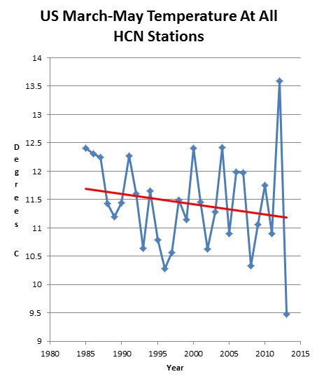
Warmer springs? Are you kidding. Springs have been getting colder for a good long while now. More evidence of climate science simply refusing to look at reality.
 
Records of when the cherry trees on the national mall bloomed have been kept since 1921.

D.C.'s cherry blossoms have shifted 5 days earlier

Last year, the USDA updated their planting maps to reflect the warming weather.

USDA Unveils New Plant Hardiness Zone Map / January 25, 2012 / News from the USDA Agricultural Research Service
---
The new map is generally one 5-degree Fahrenheit half-zone warmer than the previous map throughout much of the United States. This is mostly a result of using temperature data from a longer and more recent time period; the new map uses data measured at weather stations during the 30-year period 1976-2005. In contrast, the 1990 map was based on temperature data from only a 13-year period of 1974-1986
---

The flowers bloom earlier. Birds are arrive earlier. Pollen hits the air earlier. Wildfire seasons start earlier. And it's not because spring is getting colder.
 
---
The new map is generally one 5-degree Fahrenheit half-zone warmer than the previous map throughout much of the United States. This is mostly a result of using temperature data from a longer and more recent time period; the new map uses data measured at weather stations during the 30-year period 1976-2005. In contrast, the 1990 map was based on temperature data from only a 13-year period of 1974-1986


screenhunter_243-may-14-21-40.jpg


Guess you just found some more people who believe in computer models more than they believe in reality.
 
From the study overview:

The new study builds upon a previous USGS snowpack investigation which showed that, until the 1980s, the northern Rocky Mountains experienced large snowpacks when the central and southern Rockies experienced meager ones, and vice versa. Yet, since the 1980s, there have been simultaneous snowpack declines along the entire length of the Rocky Mountains, and unusually severe declines in the north.

Each year we looked at temperature and precipitation variations and the amount of water contained within the snowpack as of April," said USGS scientist Greg Pederson, the lead author of the study. "Snow deficits were consistent throughout the Rockies due to the lack of precipitation during the cool seasons during the 1930s – coinciding with the Dust Bowl era. From 1980 on, warmer spring temperatures melted snowpack throughout the Rockies early, regardless of winter precipitation. The model in turn shows temperature as the major driving factor in snowpack declines over the past thirty years."

USGS Release: Warmer Springs Causing Loss of Snow Cover throughout the Rocky Mountains (5/13/2013 2:00:00 PM)

It's interesting to see SSDD now rejecting observational data!!!
 

Forum List

Back
Top