Tracking the el nino

650x366_07111548_hd21.jpg
this would be good news for drought stricken CA.
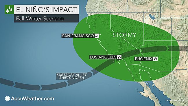
The desert south west would receive a good amount of moisture if this persists. The cold pocket now forming near the tip of Baja will not be welcomed by those folks. It signals the flip is about to occur and that warm water is now no longer being pumped up the coast line, cold water is and it is surfacing.
LOL. I do believe that we will still be waiting for that flip in January of 2016.
And yet, The weather pattern in the Midwest is still the same.Below normal temperatures in the north part of the Midwest coming south, still.

Boy, jc, that certainly looks like below temperatures going south;

http://www.weather.com/maps/current

acttemp_600x405.jpg

US Current Temperatures
did you see the weather in the Mid central states over the last week? What do you supposed caused that besides the moisture from the Gulf Coast? Hmmmm cold from the north above Minneapolis, MN. It is the same weather pattern for most of the summer.
 
Strong!!!!

Text of CPC weekly update that has Nino 3.4 at +1.5C.

http://www.cpc.noaa.gov/products/analys ... ts-web.pdf


Niño 4: +1.1°C
Niño 3.4: +1.5°C
Niño 3: +2.1C
Niño 1+2: +3.3°C

My Goodness, ol' Billy Bob done crashed and burned one more time.

Oh, that's right, it is all altered data, just to prevent the world class forecasts of Billy Bob from looking like they are so.

Yes, a strong El Nino right now, and maybe a super El Nino by fall. And record for precipitation and heat being set around the world.

Keep on deluding yourselves.. The warm spike will be short lived

sst_monthly.gif
 
"The warm spike will be short lived". LOL

I think you said that in April of this year. Now if you continue to say it to April of next year, you might finally have said something with a bit of truth in it. Well, you have had your weekly spanking on this issue, please look forward to your next one this coming week.
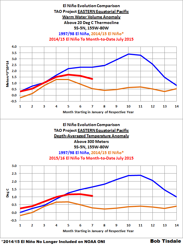
The amount of warm water is declining rapidly. Your warm water spike in regions 3.4 will not last very long. Thanks for playing..

06-tao-wwv-and-t300-east.png
 
OK, Mr. Billy Bob, see you here next week, same time, same place, same results. LOL
2cmpzk6.jpg

Even the Canadians are now showing the blob being decoupled and cold pools growing along the coast. Also showing significant cooling now reaching the arctic areas.

Looks to me like the trend has already broken and that the temp spike will most certainly be short lived.
 
Someone chose the wrong goddamn nino to whine about not happening!!!!!!!!!!!!!!!!!!!!!!!!!111


Eric Blake ‏@EricBlake12 · 23h23 hours ago
The July ECMWF fcst agrees with the CFS in showing a good chance for the strongest modern #ElNino on record #climate

pBCGpzW.png
 
Someone chose the wrong goddamn nino to whine about not happening!!!!!!!!!!!!!!!!!!!!!!!!!111


Eric Blake ‏@EricBlake12 · 23h23 hours ago
The July ECMWF fcst agrees with the CFS in showing a good chance for the strongest modern #ElNino on record #climate

pBCGpzW.png

What continent is this affecting?
 
Someone chose the wrong goddamn nino to whine about not happening!!!!!!!!!!!!!!!!!!!!!!!!!111


Eric Blake ‏@EricBlake12 · 23h23 hours ago
The July ECMWF fcst agrees with the CFS in showing a good chance for the strongest modern #ElNino on record #climate

pBCGpzW.png
Considering they are using all models it will be interesting to see what happens. I'm going with empirical evidence of past El Nino's and what it was that decoupled their power sources. The depth of the warm water is but half of the 97/98 event and fading fast so their is insufficient heat to prolong it. The fact it is already decoupled will make it even shorter. IF this makes it through Oct- Nov i will be surprised.
 
11755679_1702879599935134_29540796285720077_n.jpg

Severe Weather Europe
Latest CFS model revealing a strenghtening El Nino3.4, peaking sometime in late autumn and winter timeframe. This El Nino event is expected to be a very significant one with strong positive temperature anomaly of Pacific ocean.

Source: NOAA
where has it had any affect?

holy crap dude, that rise is like someone poured oil on the water and started it on fire, and it hasn't even happened, it's a forecast of oil burning I guess. They have no way of knowing any such severe advance in temperature. again, where is there any land mass being impacted by this?
 
This is very big news.This El Nino is up there with the biggies of the past.

Philip Klotzbach ‏@philklotzbach · 29m29 minutes ago
Weekly Nino 3 index at 2.3C. Only two El Ninos since 1950 have had monthly Nino 3 values >= 2.3C ('82-'83, '97-'98).
 
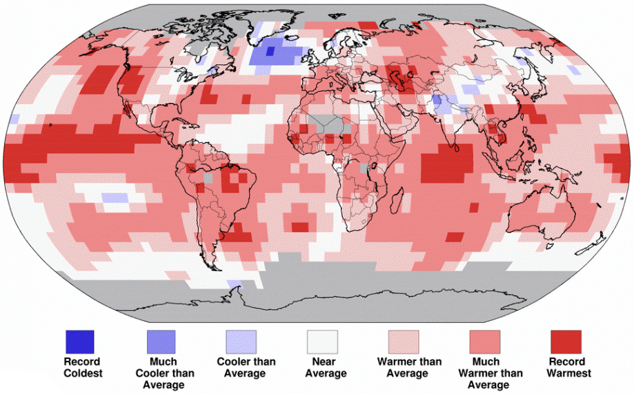
This is a new kind of heat. In more than 135 years of global temperature data, four of the five hottest months on record all happened in 2015: February, March, May, and now June.

This has been the hottest start to a year by far, according to data released today by the National Oceanic and Atmospheric Administration. The record heat is likely to continue as an already strong El Niño weather pattern in the Pacific Ocean continues to intensify, ripping more heat into the atmosphere. This monster El Niño may itself be on track to break records.


Monster El Niño Makes Record-Hot Year Look Inevitable
sure it did. Why don't you post up the global temperature sets that actually prove that statement? Temperature data.
 
California is on a 7 year cycle - this is the wet year; in 2018 we will go back into drought. There is nothing unusual about this, it's been going on my entire life. The big difference now is the insane mismanagement that goes on under ruling democrats. They have no concept of building damns and reservoirs to capture rain when it falls.
 

Forum List

Back
Top