MH17 Verdict: Real Evidence Points to US-Kiev Cover-up of Failed False Flag
By 21st Century Wire
Global Research, July 25, 2014
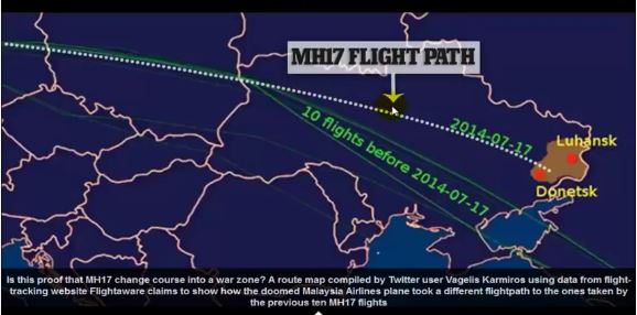
MH17: A Doomed Flight Path
A Malaysian Airlines spokesman has already confirmed that, for some unknown reason, Kiev-based Ukrainian Air Traffic Control (ATC) ordered MH17 off of its original flight path along the international air route, known as L980.
Most likely, this order was given to pilots while MH17 was still in Polish air space. L980 is one of the most popular and most congested air routes in the world, as well as a key link between major international hubs in Europe, like London Heathrow, Amsterdam Schiphol, and Frankfurt, and Asian destinations, like Singapore, Mumbai, Hong Kong and Kuala Lumpur.
As MH17 moved into Ukrainian air space, it was moved approximately 300 miles north of its usual route - putting it on a new course, flying directly over a war zone a dangerous area thats hosted a number of downed military craft over the previous 3 weeks.
Robert Mark, a commercial pilot and editor of Aviation International News Safety magazine, confirmed that most Malaysia Airlines flights from Amsterdam to Kuala Lumpur would normally travel along a route significantly further south than the route MH17 was diverted onto. Indeed, previous days flight records see here confirm that MH17 from Amsterdam to Kuala Lumpur is always assigned routes much further south than the one it took that fateful day.
The fatal event occurred somewhere in the interval between 17

28 and 17:22:30 Moscow Time. The exact time of the crash is believed to be at 5:23pm. The last available geographic coordinates can be found here on Flight Radar24:
Weather and Visibility Factor
Kiev-based air traffic controllers not only led MH17 right over its alleged target zone in Eastern Ukraines Donetsk region, but also helped make it visible.
MH17 Verdict: Real Evidence Points to US-Kiev Cover-up of Failed ?False Flag? | Global Research