Earthquake induction

C'mon baby, whole lotta shakin' goin' on...
:eek:
Earthquake deaths predicted to soar
Tuesday, February 26, 2013 - With populations growing in the world's earthquake-prone regions, catastrophic quakes will kill more people during this century than ever before, scientists at the U.S. Geological Survey warn.
Thomas L. Holzer, an engineering geologist at the survey's Menlo Park offices, and James Savage, a retired survey seismologist, estimate that 21 earthquakes with death tolls greater than 50,000 - the kind they term "catastrophic" - will occur around the world before the end of this century, while only seven such killer quakes were recorded during the 20th century. "It's not that we're having more earthquakes, it's that more people are living in seismically vulnerable buildings in the world's earthquake zones," Holzer said.

Earthquake fatalities around the world will reach at least 3.5 million in the 21st century - more than double the 1.5 million in the 20th century, the scientists forecast. "And unless we take this issue of vulnerable buildings seriously, we're going to see even more catastrophes before the end of this century," Holzer said. The current century began "most ominously," the scientists noted, when at least 700,000 people died in just seven deadly quakes within the first 10 years - an unprecedented decade of catastrophe, they reported.

The scientists based their forecast on U.N. estimates that the world's population will reach 10 billion by the end of this century. They combined that number with historic records of earthquake-prone regions where building standards are known to be weakest. Fatalities from major quakes have been estimated as far back as A.D. 1500, and modern records of quake deaths are known to be reasonably accurate. "California and Japan have shown slow progress in designing quake resistance in their buildings," Holzer noted. "But in countries like China and Iran, and all along the front region of the Himalayan range, entire cities from Kathmandu to Delhi are particularly vulnerable to catastrophic quakes."

Their statistical study is published in the current issue of Earthquake Spectra, the journal of the Earthquake Engineering Research Institute, a national organization operating out of Oakland. "There is no question that we are currently seeing a rapid increase in the number of catastrophes from earthquakes," said Richard Allen, director of UC Berkeley's Earthquake Engineering Laboratory, who was not involved in the study. "Therefore, we should not be complacent about the earthquake risks we face in the coming decades and ensure that we are taking reasonable actions to push back on the increasing trend in the number of fatalities."

Read more: Earthquake deaths predicted to soar - SFGate
 
Can Ants Predict Earthquakes?...
:confused:
Can Ants Predict When an Earthquake Will Strike?
April 14, 2013; A new study done by the University Duisburg-Essen in Germany suggests that red wood ants can sense when an earthquake is about to strike.
The study done by Gabriele Berberich from the University in Germany found that the behavior of ants changes in preparation of an earthquake and doesn't go back to normal until a day or two after the quake, according to ouramazingplanet.com.

Findings from the study suggested that ants can either detect the change in the electromagnetic field or the change in gas emissions due to particular cells that the red wood ants have.

The study also found that ants build their colonies along major fault lines. After Berberich and her colleagues followed the ants for three years from 2009 to 2012 they learned that the ants only react in preparation of earthquakes of magnitudes of 2.0 or greater, also according to ouramazingplanet.com.

In the hours before an earthquake the ants muddled around the outside of their mound instead of going about their normal activities which include going out during the day and coming back in at night.

Can Ants Predict When an Earthquake Will Strike?
 
Granny wantin' to know when New Madrid gonna go again?...

Scientist Say They Predicted Earthquake Location, Magnitude
December 24, 2013 ~ Scientists say they were able to forecast the size and location of an earthquake using GPS to study changes in the Earth’s shape.
The Georgia Institute of Technology researchers say they predicted the magnitude 7.6 Nicoya earthquake that shook Costa Rica in 2012. The Nicoya Peninsula in Costa Rica is one of the few places where land sits atop the portion of a subduction zone where the Earth’s greatest earthquakes take place. That makes it a good spot for learning how large earthquakes rupture. Subduction zones are locations where one tectonic plate is forced under another one and can often be the sites of devastating temblors. The magnitude 9.0 earthquake off the coast of Japan in 2011 was due to just such a subduction zone earthquake.

Because earthquakes greater than about magnitude 7.5 have occurred in this region roughly every 50 years, with the previous event striking in 1950, scientists have been preparing for this earthquake through a number of geophysical studies. The most recent study used GPS to map out the area along the fault storing energy for release in a large earthquake. “This is the first place where we’ve been able to map out the likely extent of an earthquake rupture along the subduction megathrust beforehand,” said Andrew Newman, an associate professor in the School of Earth and Atmospheric Sciences at the Georgia Institute of Technology. Through a series of studies starting in the early 1990s using land-based tools, the researchers mapped regions where tectonic plates were completely locked along the subduction interface. Detailed geophysical observations of the region allowed the researchers to create an image of where the faults had locked.

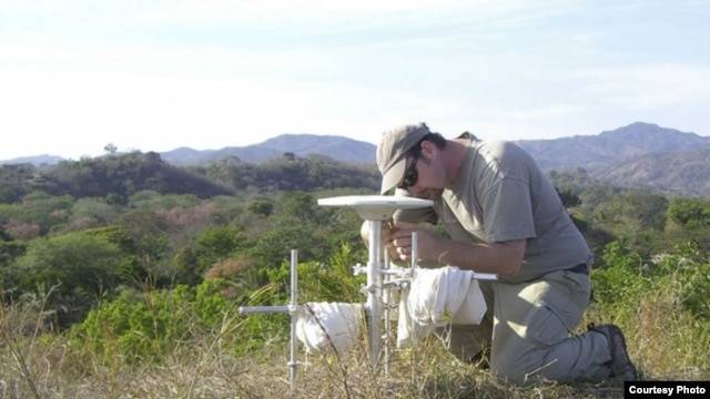
09EBCBD0-277C-41FF-B031-BF440C0908EA_w640_r1_s.jpg

Andrew Newman, an associate professor in the School of Earth and Atmospheric Sciences at the Georgia Institute of Technology, performs a GPS survey in Costa Rica's Nicoya Peninsula in 2010.

The researchers published a study a few months before the Nicoya earthquake, describing the particular locked area with the clearest potential for the next large earthquake in the region. The team projected the total amount of energy that could have developed across that region and forecasted that if the locking remained similar since the last major earthquake in 1950, then there was likely enough energy for an earthquake on the order of magnitude 7.8 there. “It occurred right in the area we determined to be locked and it had almost the size we expected,” Newman said. The researchers hope to apply what they’ve learned in Costa Rica to other environments. Virtually every damaging subduction zone earthquake occurs far offshore. “Nicoya is the only place on Earth where we’ve actually been able to get a very accurate image of the locked patch because it occurs directly under land,” Newman said. “If we really want to understand the seismic potential for most of the world, we have to go offshore.”

Because of limits in technology and scientific understanding about processes controlling fault locking and release, scientists cannot say much about precisely when earthquakes will occur. However, earthquakes in Nicoya have occurred about every 50 years, so seismologists had been anticipating another one around 2000, give or take 20 years, Newman said. Scientists have been able to reasonably map portions of these locked areas offshore using data on land, but the resolution is poor, particularly in the regions that are most responsible for generating tsunamis, Newman said. He hopes that his group’s work in Nicoya will be a driver for geodetic studies on the seafloor to observe such Earth deformation. These seafloor geodetic studies are rare and expensive today. “If we want to understand the potential for large earthquakes, then we really need to start doing more seafloor observations,” Newman said. “It’s a growing push in our community and this study highlights the type of results that one might be able to obtain for most other dangerous environments, including offshore the Pacific Northwest.” The study was published online Dec. 22, 2013, in the journal Nature Geoscience.

Scientist Say They Predicted Earthquake Location, Magnitude
 
Midwest Earthquake Risk Looming...
:eek:
Midwest Earthquake Risk Still Looms
January 23, 2014 ~ After wreaking havoc 200 years ago with huge earthquakes that made the Mississippi River flow backwards, the New Madrid Seismic Zone has continued to rattle the Midwest with about 200 quakes every year.
Whether these tiny quakes mean the fault is old and dying or locking and loading for another massive earthquake has sparked a long and lively debate among scientists. A new study suggests recent reports of the "death" of the New Madrid Seismic Zone were premature. Based on statistical computer models, which predict how many aftershocks from the 19th century quakes should hit the region, U.S. Geological Survey (USGS) scientists think the past two centuries of earthquakes suggest the New Madrid Seismic Zone is popping more often than expected. Instead of slowing down, earthquake activity on the Reelfoot Fault continues at a sprightly pace.

shake.jpg

A shakemap for the Feb. 7, 1812, New Madrid earthquake, one of four in the 1811-1812 series. The map is based on historical accounts of the shaking.

The findings were published today (Jan. 23) in the journal Science. "I don't agree that this area is dying out," said Morgan Page, lead study author and a geophysicist with the USGS in Pasadena, Calif. "It's not going to go off anytime soon, but we do have evidence that more stress is being built up now. Eventually, that energy will have to be released in a large earthquake."

At rest, or active?

The New Madrid Seismic Zone is a series of ancient faults cutting the Midwest and now hidden beneath the Mississippi River's thick mud. In late 1811 and early 1812, the New Madrid earthquakes struck on the Reelfoot Fault — four big earthquakes and many, many aftershocks emanating from the borders between Missouri, Tennessee and Arkansas. With each temblor estimated at between magnitude 7 and magnitude 8, the seismic energy shook all of eastern North America and destroyed the town of New Madrid, Mo. After the 1811-1812 earthquakes, the Reelfoot Fault could have faded from memory. Faults in the middle of continents, like the New Madrid Seismic Zone, may trigger earthquakes only rarely — every 10,000 years or more. (But this is not always the case; some "intraplate" faults, as these continent-cutting faults are called, can be speedy jackhammers.)

In recent years, a handful of studies claimed the New Madrid was settling down instead of prepping for another round of earthquakes. But the USGS team instead suggests that ongoing earthquakes in the New Madrid Seismic Zone are something new, resulting from the buildup of seismic energy on the faults. "Even though we can't predict earthquakes, we can predict the rates of aftershocks over time," Page explained. The frequency of aftershocks — smaller quakes that follow the big earthquake — decreases with time, known in seismology as Omori's Law. And in the New Madrid Seismic Zone, the aftershocks aren't following Omori's Law.

New quakes, not aftershocks

See also:

6.1 magnitude earthquake strikes off Indonesia
Sat 25 Jan 2014, A 6.1-magnitude earthquake has struck close to Indonesia's main island of Java on Saturday afternoon. Local officials say there is no risk of a tsunami.
The United States Geological Survey says the quake struck at 12:14 pm local time (0514 UTC), 39 kilometres south-southeast of the coastal town of Adipala in Central Java province at a depth of 83 kilometres. "There's no potential for a tsunami and we haven't received any reports of damage or casualties so far," Indonesian Meteorological, Climatological and Geophysical Agency chief Suharjono said.

Dozens of buildings were damaged, including 16 houses that collapsed in the town of Banyumas, as well as a mosque that crumbled, National Disaster Mitigation Agency spokesman Sutopo Purwo Nugroho said. "Authorities are continuing to asses other buildings for damage," he said. Mr Nugroho says the quake was felt in several towns up to 50 kilometres from the Javanese coast, including in the more densely populated Yogyakarta city, where at least eight homes were damaged.

People in the town of Adipala near the epicentre say they felt the ground shaking hard for up to 20 seconds, as the quake struck in the sea off the coast of southern Java. "We all just ran onto the street, there were so many people," Astri, one of the residents who was affected. "But it doesn't seem to have damaged anything around here, and we're getting back to work," she said. Indonesia sits on the Pacific "Ring of Fire", where tectonic plates collide, causing frequent seismic and volcanic activity. A 6.1-magnitude quake that struck Aceh province on Sumatra island in July 2013 killed at least 35 people and left thousands homeless.

http://www.abc.net.au/news/2014-01-25/an-indonesia-61-magnitude-earthquake/5219110
 
Last edited:
I work for the government, and let me tell you, we absolutely make earthquakes with our earth quake machine. Im not going to tell you where we plan to hit next, but the next time there is a big earth quake, just assume that it was caused by us.

Earth quakin is our business, and business is good.
 

Forum List

Back
Top