When is a hurricane not a hurricane?

wirebender

Senior Member
Mar 31, 2011
1,723
123
48
NC
When is a hurricane not a hurricane? Apparently the answer to that questionis when the warmist alarmists need something to wring their hands over and feel the need to scare as much of the population as possible back into AGW lockstep.

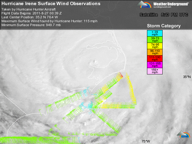
Cape Lookout, NC was Irene's southernmost point of landfall in the US and the eye of the storm passed directly over the weather station there. In addition, there were two other stations in the area; one in Beaufort and the onslow bouy offshore and to the south of Cape Lookout; and the Hatteras station further to the north.

Here is what the station read as the eye of the storm made landfall at Cape Lookout. The purple line shows the barometric pressure falling, the blue line shows the sustained wind speed, and the green bar across the top shows the minimum sustained wind speed necessary in order for a storm to be classified as a hurricane.

Note the classic signature as the eye passes directly over the measuring station. Barometric pressure dropping steeply and wind speed falling off sharply as the eye passes.

irene-at-landfall-wind-pressure.jpg


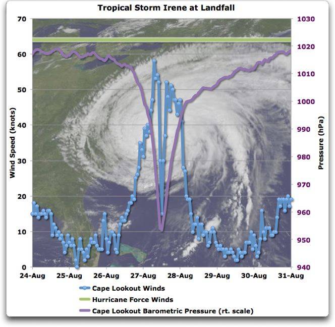
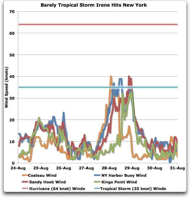
As you can see, the sustained winds of Irene, while clearly a strong tropical storm, never approached hurricane force even at landfall, much less afterwards. Here is what she looked like upon reaching New York; barely a tropical storm.

irene-at-ny-winds-pressure.jpg


Here is a link to just a small example of the fraud perpetrated by the alarmists who people are supposed to "trust" to tell them what is going on in an emergency:

Broadcast journo exaggerates flood - YouTube
 
Last edited:
Tropical cyclone - Wikipedia, the free encyclopedia

Hurricane or typhoon

A hurricane or typhoon (sometimes simply referred to as a tropical cyclone, as opposed to a depression or storm) is a system with sustained winds of at least 33 metres per second (64 kn) or 74 miles per hour (119 km/h).[15] A cyclone of this intensity tends to develop an eye, an area of relative calm (and lowest atmospheric pressure) at the center of circulation. The eye is often visible in satellite images as a small, circular, cloud-free spot.

The presence of an eye indicates it probably was a hurricane.
 
Me too. Let's hope it speeds up a little so you get SOMETHING.....Instead of "nothing".
Fucking Texan moron.
hurrican Irene damage - Google Search

Don't you have a Costa Rican 12 year old to molest ? That is you right ? The child molester who fled the US because he got caught selling popsicles with ruphie's in them to the little girls ? Or was the boy you were into ?
 
Last edited:
Tropical cyclone - Wikipedia, the free encyclopedia

Hurricane or typhoon

A hurricane or typhoon (sometimes simply referred to as a tropical cyclone, as opposed to a depression or storm) is a system with sustained winds of at least 33 metres per second (64 kn) or 74 miles per hour (119 km/h).[15] A cyclone of this intensity tends to develop an eye, an area of relative calm (and lowest atmospheric pressure) at the center of circulation. The eye is often visible in satellite images as a small, circular, cloud-free spot.

The presence of an eye indicates it probably was a hurricane.

Either you don't understand your definition, or you are unable to read a simple graph or both. By your own definition, in order to be classified as a hurricane, the storm must have SUSTAINED WINDS of at least 74 miles per hour. The measuring station on Cape Lookout where the storm first made landfall registered sustained winds of less than 60 miles per hour. The winds were clearly not hurricane force and all of those alarmists reporting on the storm knew it and called it a hurricane even though it wasn't.

Why might they do that?
 
When is a hurricane not a hurricane?

When the winds go below the minimum speed, of course.

FYI, here's a link leading to images of the aftermath in Vermont of what became tropical storm Irene.

Hurrican Ireme damaged Vermont - Google Search

As you can see, exactly as I'd predicted before the storm even hit the NC coast, up North, where you can pretty much expect that the windstorm will have lost its power, it's the RAIN, not the wind, that does the most damage.

Mountainous Vermont and upstate NY got about 12'' of rain in 24 hours.

That rain falls on the broad mountains and gathering momentum and concentrating as it makes it way down the creeks and streams and rivers, it becomes life threatening as it tears through or domolishes anything that gets in its way.

I've seen this happen personally when Diane dumped between 14 and 19 inches of rain on most of the E coast in 55.

That hurricane that had also became nothing more than a tropical storm and it still killed over 1,500 souls in August 1955.

Diane ravaged the Carolinas through New England killing people all along its path with RAIN, not wind.
 
Last edited:
When is a hurricane not a hurricane?

When the winds go below the minimum speed, of course.

FYI, here's a link leading to images of the aftermath in Vermont of what became tropical storm Irene.

Hurrican Ireme damaged Vermont - Google Search

As you can see, exactly as I'd predicted before the storm even hit the NC coast, up North, where you can pretty much expect that the windstorm will have lost its power, it's the RAIN, not the wind, that does the most damage.

Mountainous Vermont and upstate NY got about 12'' of rain in 24 hours.

That rain falls on the broad mountains and gathering momentum and concentrating as it makes it way down the creeks and streams and rivers, it becomes life threatening as it tears through or domolishes anything that gets in its way.

I've seen this happen personally when Diane dumped between 14 and 19 inches of rain on most of the E coast in 55.

That hurricane that had also became nothing more than a tropical storm and it still killed over 1,500 souls in August 1955.

Diane ravaged the Carolinas through New England killing people all along its path with RAIN, not wind.

The question remains. Why would alarmists call, and continue to call a tropical storm a hurricane?
 
What causes the most damage in a Hurricane? It depends on they the hurricane and the locale. A tropical storm can be very deadly as can be attested by those people in Central America where mud slides are common from water deluged mountain sides. But the major damage from Hurricane Andrew was the 170 mph winds. The storm surge was high but landfall was in an area not susceptible to storm surges. And Storm surges are usually what causes the most destruction like in Katrina along the Gulf coast.

Was this a Hurricane. Yes it was. When did it become a Tropical Storm? Because the station you have included the statistics from was hit by the eye it would seem logical that the highest sustained windspeed would have occurred there. That may not be the case because the eastern portion of the storm was still over the water where sustained windspeed has less friction and it is probable that hurricane force winds were still present in that portion of the storm. Any hurricane as it moves over cooler water loses its power and this storm is no exception. As the world continues to heat up and the ocean absorbs that heat (if the warm up continues) the east coast can start to expect more hurricanes keeping hurricane strength winds as they race up the coast line.
 
Was this a Hurricane. Yes it was.[/quote]

Not when it made landfall and where you get the idea that the strongest winds in a hurricane are not along the eyewall, I can't say but perhaps you should read up a bit on the storms.

That may not be the case because the eastern portion of the storm was still over the water where sustained windspeed has less friction and it is probable that hurricane force winds were still present in that portion of the storm.

May not be the case? Possible that hurricane force winds were present? I find nothing indicating any of the offshore bouys measured hurricane force winds either. The fact is that the strongest winds are found at the eyewall and the winds in the eyewall of irene when it made landfall were considerably less than required to catergorize it as a hurricane.

So the question remains, why would alarmists call the storm, and continue to call the storm a hurricane when it made land fall when it is clear that it was not?

As the world continues to heat up and the ocean absorbs that heat (if the warm up continues) the east coast can start to expect more hurricanes keeping hurricane strength winds as they race up the coast line.

Which begs the question.... why has it been nearly 1200 days since a hurricane has made landfall here if global warming is supposed to increase both the frequency and magnitude of the storms?
 
9rjAx.png


This is based off of recon, obs, buoy's, ect. (Yellow=hurricane sustain winds)

Western or northwestern quad of Irene never had hurricane force winds based on recon data the last 12-18 hours leading up to the landfall. The southwesterly shear(inducing dry air into the circulation) was creating ewrc after ewrc with Irene. The outter band of the west and northwestern quad was a good 100 miles away from the center point(focal point)...Recon reported 70-75 knot flight level winds=55 knots within this quad. Surface observations supported such. The thing was within the eastern quad you had winds at 95-100knots=70-75 knots at the surface, with surface "wave" estimates, which are what smrf are finding 70-75 knots at landfall and within the last 6 hours before landfall. There was also some gust within the 90 mph range reported, which would support near hurricane strength. Most likely only the islands and maybe a small strip of land near the coastline had anything over hurricane force.

Most importantly to note a drop sounde found that the winds within the southeastern quad of this cyclone was close to 80 knots at the surface within 3-4 hours of landfall. The strength of a hurricane is based on the highest sustain winds found at any one point. That is how hurricanes are judged. Was it a hurricane AT new jersey? HELL NO. Likely a 55 knot tropical storm, which is supported by land obs. New york was likely a 45 knot tropical storm. Likely couldn't mix the winds to the surface as it was becoming extratropical and little convective activity to do so. You have to increase your reduction level from flight level when you have little convection to mix it down.

Also remember that winds within a few miles of the ocean are normally far lower then what they would be over the smooth ocean(friction of the land, but you can still have as high with wind gust as those mix down). So a 75 knot hurricane a few miles inland would give about 55-60 knot sustain winds...So the highest winds of course will remain over the ocean or the beaches. Andrew 1992 over the "very" beach didn't likely give cat5 sustain winds either even 20 miles inland.

Another good one to show surface winds

post-143-0-29840600-1314465766.gif


Nhc discussion as it was about ready to make landfall

HURRICANE IRENE DISCUSSION NUMBER 28
NWS NATIONAL HURRICANE CENTER MIAMI FL AL092011
500 AM EDT SAT AUG 27 2011

SATELLITE IMAGERY AND COASTAL RADAR DATA SHOW THAT IRENE HAS LOST
SOME ORGANIZATION THIS MORNING. THE CLOUD TOPS HAVE WARMED
SIGNIFICANTLY IN THE WESTERN SEMICIRCLE...AND THERE IS A LACK OF
CONVECTIVE BANDING IN THE SOUTHWESTERN QUADRANT IN THE RADAR DATA.
THIS SUGGESTS THAT DRY AIR SEEN IN WATER VAPOR IMAGERY TO THE WEST
OF IRENE IS STARTING TO ENTRAIN INTO THE HURRICANE. AN AIR FORCE
RESERVE HURRICANE HUNTER AIRCRAFT CONTINUES TO OBSERVE 90-100 KT
WINDS AT 700 MB OVER THE EASTERN SEMICIRCLE. HOWEVER...THE HIGHEST
SURFACE WIND ESTIMATES FROM THE SFMR HAVE ONLY BEEN 70-75 KT. THE
INITIAL INTENSITY IS REDUCED TO 80 KT...AND THIS COULD BE A LITTLE
GENEROUS. DESPITE THE DECREASE IN CONVECTIVE ORGANIZATION...THE
AIRCRAFT REPORTS THAT THE CENTRAL PRESSURE REMAINS NEAR 952 MB.

After landfall


HURRICANE IRENE DISCUSSION NUMBER 29
NWS NATIONAL HURRICANE CENTER MIAMI FL AL092011
1100 AM EDT SAT AUG 27 2011

NATIONAL WEATHER SERVICE DOPPLER RADAR AND SURFACE OBSERVATIONS
INDICATE THAT IRENE MADE LANDFALL AROUND 1130 UTC JUST WEST OF CAPE
LOOKOUT NORTH CAROLINA. THE ESTIMATED INTENSITY AT LANDFALL WAS
75 KT. THIS WAS BASED ON A PEAK FLIGHT-LEVEL WIND OF 98 KT AND A
SFMR SURFACE WIND OF 69 KT. A DROPSONDE RELEASED BY A NOAA
AIRCRAFT MEASURED A MINIMUM PRESSURE OF 951 MB AROUND THE TIME
OF LANDFALL. THE INITIAL INTENSITY WILL REMAIN 75 KT.

98 knot flight level winds=75 knots. Smrf 69 knots=70 knots, but mostly east of the center off shore.

al09201108280130contour.png


Near New Jersey. It is debated that it even had hurricane force winds at this point as the smrf shown that it may not of mixed down to the surface.
 
Last edited:

Forum List

Back
Top