2012 for real...

ErikViking

VIP Member
Apr 26, 2006
1,389
135
85
Stockholm - Sweden
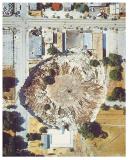
Tropical Storm Agatha swept across Central America yesterday, bringing torrential rain that killed more than 100 people and opened a 60m-deep sinkhole in Guatemala City which reportedly swallowed up a three-storey building.
.
.
.
Guardian

I have never seen anything like this...
 
It's because I took the SUV to my sister in laws house and poured all that deadly CO2 into the fragile atmosphere.

Sorry
 
It's because I took the SUV to my sister in laws house and poured all that deadly CO2 into the fragile atmosphere.

Sorry

Should I have posted this in another section to avoid climate debate?

But seriously, have you seen anything like that? I wonder what the people inside experienced...? Shrug.
 
Sinkholes are common in karst topography. They are very common in Florida and they have an organization to study them.

FGS, Sinkholes in Florida

The assertion that TS Agatha helped form the sinkhole is ludicrous......the thing has been forming for decades if not hundreds of years. It is just another attempt to frighten the natives with more global warming BS.
 
Truly unbelievable.

guatemala_sink_hole_2.jpg
 
Here are a few more including one big one in Florida...you guys should read more, these are common.
 

Attachments

  • $sinkhole.jpg
    $sinkhole.jpg
    2.9 KB · Views: 87
  • $florida sinkhole.jpg
    $florida sinkhole.jpg
    7.1 KB · Views: 98
  • $arizona sinkholes.jpg
    $arizona sinkholes.jpg
    3.7 KB · Views: 90
Everyday is an opportunity to learn something new... those things can reach over 100 meters down...

I don't know if could stand living in an area where those things are prone to happen. Swallowed by the earth... no way.
 
I have the same reaction to sink holes as I do to the Obama and Democratic Party control of the country. Of course.. they are far more frequent with Obama and the Dems. .. almost daily

just saying...:eusa_eh:
 
Last edited:
The City of Pittsburgh KS is built on top of deep underground coal mines that kriss kross the city. Sometimes you can hear thunder rumbling through those underground, mostly water filled tunnels long before a cloud is visible on the horizon. I often wondered how long it would be before that all collapsed swallowing up most of the city? Nobody seemed very worried about that though.

I read a book some years ago called Dallas Down. A pretty good yarn. The plot was that we have been pumping so much water out of the aquifers that geological tests showed that a vast cavern had developed below the surface and it was a relatively short period of time before that cavern would cave in creating a sink hole that would swallow up most of the City of Dallas. They solved the problem by re-routing the Rio Grande and running the water into the cavern and filling it back up.

I asked a geologist friend how plausible the scenario was. He said enormous sink holes were quite plausible and not all that uncommon. So sure one could develop within a large city. He didn't think rerouting the Rio Grande to fill up an aquifer was too plausible though.
 
I have the same reaction to sink holes as I do to the Obama and Democratic Party control of the country. Of course.. they are far more frequent with Obama and the Dems. .. almost daily

just saying...:eusa_eh:

Now you know how we felt when bush was screwing the world, and without a clue. :eusa_drool:
 
Given that sinkholes are formed as calcium is dissolved by water, it probably isn't entirely a stretch to suggest that very heavy storm events might make sink holes happen more frequently.
 
Given that sinkholes are formed as calcium is dissolved by water, it probably isn't entirely a stretch to suggest that very heavy storm events might make sink holes happen more frequently.


Yes it is. It takes centuries to dissolve limestone. That sinkhole in Guatemala has been a work in progress for over 1000 years.
 
The City of Pittsburgh KS is built on top of deep underground coal mines that kriss kross the city. Sometimes you can hear thunder rumbling through those underground, mostly water filled tunnels long before a cloud is visible on the horizon. I often wondered how long it would be before that all collapsed swallowing up most of the city? Nobody seemed very worried about that though.

I read a book some years ago called Dallas Down. A pretty good yarn. The plot was that we have been pumping so much water out of the aquifers that geological tests showed that a vast cavern had developed below the surface and it was a relatively short period of time before that cavern would cave in creating a sink hole that would swallow up most of the City of Dallas. They solved the problem by re-routing the Rio Grande and running the water into the cavern and filling it back up.

I asked a geologist friend how plausible the scenario was. He said enormous sink holes were quite plausible and not all that uncommon. So sure one could develop within a large city. He didn't think rerouting the Rio Grande to fill up an aquifer was too plausible though.


Aquifers are rock formations made up of a porous material. Sandstone is a very common
aquifer material as it is very porous. The problem with aquifer depletion is that they do indeed collapse. Phoenix AZ is about three feet lower than when it was founded due to aquifer depletion. Rerouting a river will not recharge an aquifer, once the aquifer is depleted to a certain point it collapses and can no longer be recharged because it has now lost its porosity. Also sinkholes can form but they would be very small and completely unlike the sinkholes seen in karst topography. Richmond CA recently had a sinkhole form and that would be the type you would see in Dallas (provided there is not a deeper very thick, over 300 feet thick, limestone layer that would indeed generate a karst type sinkhole)
but nothing else would happen.

One other thing to consider is that water pulled up from an aquifer is called "fossil water" because it takes around 1000 years for water to flow through an aquifer, that is the reason why you can't recharge an aquifer with a river, the water simply runs over the formation with very little being absorbed.

Yet another example of how the world operates on a much longer time frame than we humans.

Interesting Westwall. I am sure no expert on this stuff. Are you a geologist?

Aquifers are simply mysterious sources of water to me though I am generally intrigued by all Earth sciences. I do know that the huge Ogallala Aquifer in the US is slowly being depleted which does raise the question about water source will eventually be used to replace it. The Estancia Valley beginning about 35 miles east of Albuquerque sits on top of a vast underground lake. When settlers first started using that water, a windmill would pump now. Now they have to go deeper and use mechanical pumps so presumably that water source will run out eventually too.

But conversely, even though we were in prolonged drought, our pump in our well in the east mountains in the 1990's was deep (almost 400 feet) and we had it tested each year for pollutants and also for the water level. Each of the 14 years we were out there, the well actually gained a few inches, and there were a lot of us using that aquifer. So go figure.
 
Last edited:
The City of Pittsburgh KS is built on top of deep underground coal mines that kriss kross the city. Sometimes you can hear thunder rumbling through those underground, mostly water filled tunnels long before a cloud is visible on the horizon. I often wondered how long it would be before that all collapsed swallowing up most of the city? Nobody seemed very worried about that though.

I read a book some years ago called Dallas Down. A pretty good yarn. The plot was that we have been pumping so much water out of the aquifers that geological tests showed that a vast cavern had developed below the surface and it was a relatively short period of time before that cavern would cave in creating a sink hole that would swallow up most of the City of Dallas. They solved the problem by re-routing the Rio Grande and running the water into the cavern and filling it back up.

I asked a geologist friend how plausible the scenario was. He said enormous sink holes were quite plausible and not all that uncommon. So sure one could develop within a large city. He didn't think rerouting the Rio Grande to fill up an aquifer was too plausible though.


Aquifers are rock formations made up of a porous material. Sandstone is a very common
aquifer material as it is very porous. The problem with aquifer depletion is that they do indeed collapse. Phoenix AZ is about three feet lower than when it was founded due to aquifer depletion. Rerouting a river will not recharge an aquifer, once the aquifer is depleted to a certain point it collapses and can no longer be recharged because it has now lost its porosity. Also sinkholes can form but they would be very small and completely unlike the sinkholes seen in karst topography. Richmond CA recently had a sinkhole form and that would be the type you would see in Dallas (provided there is not a deeper very thick, over 300 feet thick, limestone layer that would indeed generate a karst type sinkhole)
but nothing else would happen.

One other thing to consider is that water pulled up from an aquifer is called "fossil water" because it takes around 1000 years for water to flow through an aquifer, that is the reason why you can't recharge an aquifer with a river, the water simply runs over the formation with very little being absorbed.

Yet another example of how the world operates on a much longer time frame than we humans.

Interesting Westwall. I am sure no expert on this stuff. Are you a geologist?

Aquifers are simply mysterious sources of water to me though I am generally intrigued by all Earth sciences. I do know that the huge Ogallala Aquifer in the US is slowly being depleted which does raise the question about water source will eventually be used to replace it. The Estancia Valley beginning about 35 miles east of Albuquerque sits on top of a vast underground lake. When settlers first started using that water, a windmill would pump now. Now they have to go deeper and use mechanical pumps so presumably that water source will run out eventually too.

But conversely, even though we were in prolonged drought, our pump in our well in the east mountains in the 1990's was deep (almost 400 feet) and we had it tested each year for pollutants and also for the water level. Each of the 14 years we were out there, the well actually gained a few inches, and there were a lot of us using that aquifer. So go figure.


Hi Foxfyre,

Yes I am a geologist. Aquifer depletion is a problem the world over. Your particular case sounds like you are feeding from a "Perched Water Table" which can recharge a little faster than normal aquifers as they are much smaller in extent and have a larger area to recharge from relative to their size (in general).
 
I have the same reaction to sink holes as I do to the Obama and Democratic Party control of the country. Of course.. they are far more frequent with Obama and the Dems. .. almost daily

just saying...:eusa_eh:

LOL. We put up with Bushie baby for eight years, you get to put up with President Obama for eight years. And if the Teabaggers continue to have influence in the Republican Party, another Democrat for four to eight years after that.:lol:
 
Aquifers are rock formations made up of a porous material. Sandstone is a very common
aquifer material as it is very porous. The problem with aquifer depletion is that they do indeed collapse. Phoenix AZ is about three feet lower than when it was founded due to aquifer depletion. Rerouting a river will not recharge an aquifer, once the aquifer is depleted to a certain point it collapses and can no longer be recharged because it has now lost its porosity. Also sinkholes can form but they would be very small and completely unlike the sinkholes seen in karst topography. Richmond CA recently had a sinkhole form and that would be the type you would see in Dallas (provided there is not a deeper very thick, over 300 feet thick, limestone layer that would indeed generate a karst type sinkhole)
but nothing else would happen.

One other thing to consider is that water pulled up from an aquifer is called "fossil water" because it takes around 1000 years for water to flow through an aquifer, that is the reason why you can't recharge an aquifer with a river, the water simply runs over the formation with very little being absorbed.

Yet another example of how the world operates on a much longer time frame than we humans.

Interesting Westwall. I am sure no expert on this stuff. Are you a geologist?

Aquifers are simply mysterious sources of water to me though I am generally intrigued by all Earth sciences. I do know that the huge Ogallala Aquifer in the US is slowly being depleted which does raise the question about water source will eventually be used to replace it. The Estancia Valley beginning about 35 miles east of Albuquerque sits on top of a vast underground lake. When settlers first started using that water, a windmill would pump now. Now they have to go deeper and use mechanical pumps so presumably that water source will run out eventually too.

But conversely, even though we were in prolonged drought, our pump in our well in the east mountains in the 1990's was deep (almost 400 feet) and we had it tested each year for pollutants and also for the water level. Each of the 14 years we were out there, the well actually gained a few inches, and there were a lot of us using that aquifer. So go figure.


Hi Foxfyre,

Yes I am a geologist. Aquifer depletion is a problem the world over. Your particular case sounds like you are feeding from a "Perched Water Table" which can recharge a little faster than normal aquifers as they are much smaller in extent and have a larger area to recharge from relative to their size (in general).

And I am Napoleon. :lol:Walleyes, your one pathetic lying son of a bitch. You have flaunted a massive ignorance of the most basic geology repeatedly on this board.

What you are is a pathological liar.
 
The City of Pittsburgh KS is built on top of deep underground coal mines that kriss kross the city. Sometimes you can hear thunder rumbling through those underground, mostly water filled tunnels long before a cloud is visible on the horizon. I often wondered how long it would be before that all collapsed swallowing up most of the city? Nobody seemed very worried about that though.

I read a book some years ago called Dallas Down. A pretty good yarn. The plot was that we have been pumping so much water out of the aquifers that geological tests showed that a vast cavern had developed below the surface and it was a relatively short period of time before that cavern would cave in creating a sink hole that would swallow up most of the City of Dallas. They solved the problem by re-routing the Rio Grande and running the water into the cavern and filling it back up.

I asked a geologist friend how plausible the scenario was. He said enormous sink holes were quite plausible and not all that uncommon. So sure one could develop within a large city. He didn't think rerouting the Rio Grande to fill up an aquifer was too plausible though.


Aquifers are rock formations made up of a porous material. Sandstone is a very common
aquifer material as it is very porous. The problem with aquifer depletion is that they do indeed collapse. Phoenix AZ is about three feet lower than when it was founded due to aquifer depletion. Rerouting a river will not recharge an aquifer, once the aquifer is depleted to a certain point it collapses and can no longer be recharged because it has now lost its porosity. Also sinkholes can form but they would be very small and completely unlike the sinkholes seen in karst topography. Richmond CA recently had a sinkhole form and that would be the type you would see in Dallas (provided there is not a deeper very thick, over 300 feet thick, limestone layer that would indeed generate a karst type sinkhole)
but nothing else would happen.

One other thing to consider is that water pulled up from an aquifer is called "fossil water" because it takes around 1000 years for water to flow through an aquifer, that is the reason why you can't recharge an aquifer with a river, the water simply runs over the formation with very little being absorbed.

Yet another example of how the world operates on a much longer time frame than we humans.

Interesting Westwall. I am sure no expert on this stuff. Are you a geologist?

Aquifers are simply mysterious sources of water to me though I am generally intrigued by all Earth sciences. I do know that the huge Ogallala Aquifer in the US is slowly being depleted which does raise the question about water source will eventually be used to replace it. The Estancia Valley beginning about 35 miles east of Albuquerque sits on top of a vast underground lake. When settlers first started using that water, a windmill would pump now. Now they have to go deeper and use mechanical pumps so presumably that water source will run out eventually too.

But conversely, even though we were in prolonged drought, our pump in our well in the east mountains in the 1990's was deep (almost 400 feet) and we had it tested each year for pollutants and also for the water level. Each of the 14 years we were out there, the well actually gained a few inches, and there were a lot of us using that aquifer. So go figure.

Interesting aquifer you have there.

NMT Community Archive: Pumping test interpretations in the Estancia Valley, Torrance County, New Mexico

Title: Pumping test interpretations in the Estancia Valley, Torrance County, New Mexico
Authors: Guerra, Ruben M.
Issue Date: 17-Aug-2009
Abstract: This paper presents the analysis of six pumping tests per formed on five wells in the Estancia Valley, Torrance County, New Mexico. Well driller's logs and geophysical well logs were used in the interpretation. Two aquifer systems separated by a non-uniform clay bed, were identified. The aquifers appear to be partially confined, however enough data were not available to confirm this conclusion. Three wells are partially penetrating in the deeper aquifer and two partially penetrated only the shallow aquifer. For the shallow aquifer values of transmissivity of 12,000 gal./day/ft. and storativity of 1.36 x 10⁻⁴ were computed. As for the deep aquifer system, a transmissivity value of 6,000 gal./day/ft. was obtained taking into account well development and sanding up that took place during the pumping tests.
URI: NMT Community Archive: Pumping test interpretations in the Estancia Valley, Torrance County, New Mexico
Appears in Collections: Independent Studies

Except that you drew an erroneous conclusion--you do that a lot don't you? Our well was in neither the Estancia Valley nor Torrance County.
 

Forum List

Back
Top