Tropical storm ISAAC

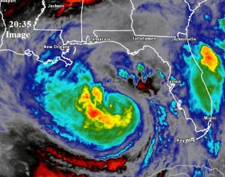
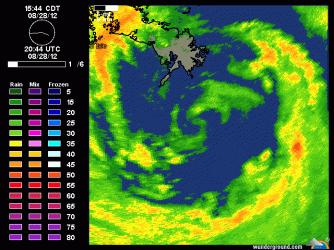
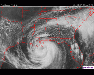
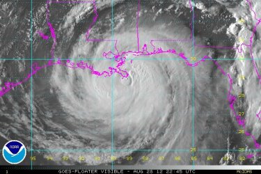
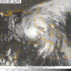
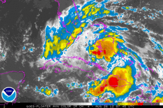
Southerly shear is still keeping the MLC and LLC displaced by about 50 miles, but this thing is looking pretty good on IR. This could start strengthening very soon as the models are forecasting the shear to lessen. You can also notice there's a outflow channel to the northeast quad moving air from the system to the northeast...This is occurring as there's a trough at 500 millibars at 82-84 north just to the north of this cyclone. gfs 2012082618 Forecast 850500shear Java Animation The computer model forecast this to pull out to the northeast as the cyclone turns northwestward by 24-36 hours.

North Atlantic - Upper Level WV/IR - Latest Available - Large Scale

Some of this shear is also being caused by a ULL over the Yucatan at 22/90.

North Atlantic - 24hr Shear Tendency - Latest Available - Large Scale

Shear is lowering.

At 24-36 hours the second trough drops out of the upper midwest and breaks the ridging to the north. This allows the tropical cyclone to turn northward. gfs 2012082618 Forecast slp Java Animation

http://moe.met.fsu.edu/cgi-bin/gfstc2.cgi?time=2012082618&field=850-500mb+Shear&hour=018hr

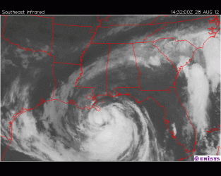
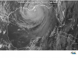
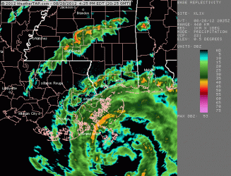
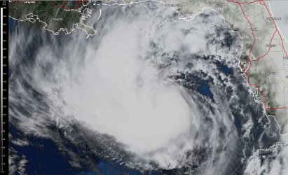
This trough is from 1013-500 millibars as you can see. New orleans is very much threaten by this system, and if the models are right about the anticyclone forming over this system this could be 100-115 mph storm at landfall.
 

Attachments

  • $20120827_0145_goes13_x_ir1km_bw_09LISAAC_55kts-992mb-240N-825W_100pc.jpg
    $20120827_0145_goes13_x_ir1km_bw_09LISAAC_55kts-992mb-240N-825W_100pc.jpg
    16.1 KB · Views: 50
000
wtnt44 knhc 270250
tcdat4

tropical storm isaac discussion number 24
nws national hurricane center miami fl al092012
1100 pm edt sun aug 26 2012

satellite imagery has shown an increase in the area of cold cloud
tops near the center of isaac. However...there has not been any
significant change in organization in radar data from key west
this evening. In fact...the aircraft fixes have been near the
southeastern edge of the convective cluster seen in both satellite
and radar imagery. An earlier ship observation and sfmr
measurements of 50-55 kt supported increasing the intensity to 55
kt on the intermediate advisory. Since that time...the aircraft
has not found any stronger winds so the initial wind speed remains
unchanged. The large scale environmental factors...warm
waters...and a conducive upper-air pattern favor strengthening
during the next couple of days. However...the lack of an inner core
and large wind field could continue to be impeding factors for
significant strengthening in the short term. The nhc intensity
forecast shows a gradual increase in wind speed during the next 12
hours or so...followed by more steady strengthening. The official
forecast is close to the ships/lgem guidance and the intensity
consensus.

Aircraft and radar center fixes indicate that isaac jogged westward
and slowed down this evening. However...the longer term motion is
285/12 kt. The models show isaac turning toward the northwest into
a break in the subtropical ridge. Although the models agree on
this turn...there is an unusually large spread in the track guidance
after 24 hours. The spread of landfall locations along the northern
gulf coast ranges from the texas/louisiana border eastward to the
alabama/florida border with the hwrf...gfdl...and gfs near the
western edge and the ukmet and ecmwf along the eastern edge of the
envelope. Overall...the consensus has shifted a little westward
and the official forecast as been moved in that direction. The nhc
forecast is between the ecmwf and gfs ensemble means and near the
hfip multi-model consensus. Because of the very large spread in
the guidance...there continues to be greater than usual track
forecast uncertainty.

Throughout the period...it is important not to focus on the exact
forecast track due to forecast uncertainties and the fact that
significant hazards extend well away from the center.

Forecast positions and max winds

init 27/0300z 24.2n 82.9w 55 kt 65 mph
12h 27/1200z 25.2n 84.8w 60 kt 70 mph
24h 28/0000z 26.5n 86.7w 70 kt 80 mph
36h 28/1200z 27.9n 88.3w 80 kt 90 mph
48h 29/0000z 28.9n 89.3w 85 kt 100 mph
72h 30/0000z 30.6n 90.3w 70 kt 80 mph...inland
96h 31/0000z 33.0n 91.0w 30 kt 35 mph...inland
120h 01/0000z 36.0n 91.0w 20 kt 25 mph...inland

$$
forecaster brown
 
According to the "weather channel" the European model had a better prediction about the path than the "American model". I didn't know there was such a rivalry about the weather and American technology was losing. Twenty years ago a Cat #1 hurricane wouldn't get much hype but the times they are a changin.
 
Oil rises above $114 on storm threat, stimulus hopes


By Emma Farge | GENEVA (Reuters) - Crude oil futures rose above $114 a barrel on Monday, lifted by worries that a Tropical Storm could suspend US oil production and hints of another round of monetary stimulus by the US Federal Reserve.
 
And FINALLY the news is starting to gurgle OMG I think it's gonna hit New Orleans. . Fortunately this storm is going to actually hit them. Between that and the infrastructure upgrades they should be fine.
 
Starting to seriously strengthening....Eye developing one satellite. I expect this to be strengthening a decent clip as it is making landfall. Katrina was getting the shit kicked out of it as it was coming in. :eusa_boohoo: I'd say 95-110 mph at landfall. Of course that could charge as this thing has been very slow at getting its act together, but O'damn knowing hurricanes that could also mean on the low side too.:eusa_shhh: Intensity forecasting is a crap shot.

-Shear decreasing
-Warm sst's
-high tchp
-the friction of the land as this system will be slow should help tighten the core.
-Outflow jet to the northeast quad.

O'yes.

On the negative side
-dry air around the outter-circulation
-maybe some mid level shear
-Disorganized inner-core.
 

Attachments

  • $2035image.jpg
    $2035image.jpg
    90.2 KB · Views: 67
Last edited:
It's looking like a direct hit on New Orleans. Katrina was a miss and significantly weakened on the way in. This could be bad if the preparations since Katrina aren't up to standards.
 
So how many hurricanes have hi the gulf coast over the last 200 years?

It's amazing that people survive and that people keep rebuilding every couple years.
 
And FINALLY the news is starting to gurgle OMG I think it's gonna hit New Orleans. . Fortunately this storm is going to actually hit them. Between that and the infrastructure upgrades they should be fine.

It's looking like a direct hit on New Orleans. Katrina was a miss and significantly weakened on the way in. This could be bad if the preparations since Katrina aren't up to standards.

For some reason everyone has been in some kind of fugue state. Misreporting it's path toward the convention last weekcould be attributed to ratings. But the last five days is puzzling. It wasn't until 2:30PM today that Fox was willing to say it was going ti hit there. And the weather channel finally used the city name an hour later.
 
Satellite loop. Well, it is using the land to tighten. If it had been able to do that on its own a good 24 hours earlier, well the sky's the limit with this system.
 

Attachments

  • $sat_vis_se_loop issac 3.gif
    $sat_vis_se_loop issac 3.gif
    553.7 KB · Views: 85

Forum List

Back
Top