ScienceRocks
Democrat all the way!
- Banned
- #1
000
wtnt44 knhc 260244
tcdat4
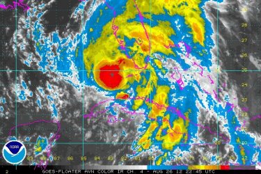
tropical storm isaac discussion number 20
nws national hurricane center miami fl al092012
1100 pm edt sat aug 25 2012
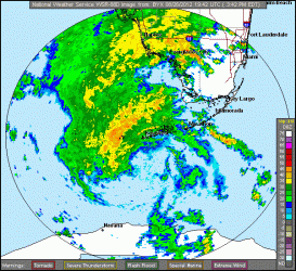
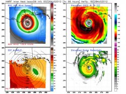
satellite and radar data from cuba show that isaac is moving
parallel to...but offshore of...the northern coast of cuba.
The hurricane hunter aircraft did not find any stronger winds
during the latter portion of the flight and the initial wind
speed remains 50 kt. However...thunderstorm activity has
increased in a band to the north and east of the center during
the past few hours and isaac may be on the verge of strengthening.
The next reconnaissance flight is expected to be in the cyclone
around 0600 utc.
The initial motion estimate is 305/15 kt. Isaac should continue on
a west-northwestward to northwestward motion during the next 24
hours or so between a large low/mid-level low pressure system over
the northwestern caribbean sea and a mid-level ridge over the
western atlantic. The model guidance is tightly clustered during
this time and shows a track over the straits of florida and near or
over the florida keys. In about 48 hours...isaac will be nearing
the western portion of the ridge and should move in a general
northwestward heading over the eastern gulf of mexico...but large
differences exist between the latest ecmwf and gfs models after
that time. The ecmwf recurves isaac ahead of a mid-latitude
trough over the eastern united states...while the gfs slows isaac
down as the trough bypasses the system and the model then turns
the cyclone westward to the south of a developing mid- to
upper-level ridge. This bifurcation is also seen in the most recent
ecmwf and gfs ensembles with about an equal number of members
showing recurvature versus a continue northwesterly track toward
the northern gulf coast. Since the uncertainty is large and either
of these scenarios are possible at this time...the nhc forecast is
lies between them. The updated track is very close to the previous
advisory through 36 hours. After that time...the track has been
adjusted westward...but it remains east of the dynamical model
consensus to retain some continuity with the previous forecast.
The upper-level environment is expected to become more conducive for
strengthening during the next couple of days as isaac moves over
the warm waters of the florida straits and eastern gulf. Steady
strengthening is expected and isaac is expected to be at or near
hurricane strength when the center reaches the florida keys.
Additional strengthening is likely while the cyclone moves over the
eastern gulf of mexico. The new intensity forecast is a little
higher than the previous advisory and is between the ships/lgem
guidance and the more aggressive hwrf model.
It is important not to focus on the exact forecast track since
significant hazards extend well away from the center. Since large
uncertainties remain in the extended portion of the forecast...it
is too early to determine exactly where and when isaac will make
landfall along the gulf coast.
Forecast positions and max winds
init 26/0300z 22.1n 77.2w 50 kt 60 mph
12h 26/1200z 23.4n 79.4w 55 kt 65 mph
24h 27/0000z 24.6n 81.8w 65 kt 75 mph...near florida keys
36h 27/1200z 25.8n 83.7w 75 kt 85 mph
48h 28/0000z 27.2n 85.2w 85 kt 100 mph
72h 29/0000z 29.5n 86.5w 90 kt 105 mph
96h 30/0000z 31.5n 86.5w 50 kt 60 mph...inland
120h 31/0000z 34.0n 86.0w 25 kt 30 mph...inland
$$
forecaster brown
wtnt44 knhc 260244
tcdat4
tropical storm isaac discussion number 20
nws national hurricane center miami fl al092012
1100 pm edt sat aug 25 2012
satellite and radar data from cuba show that isaac is moving
parallel to...but offshore of...the northern coast of cuba.
The hurricane hunter aircraft did not find any stronger winds
during the latter portion of the flight and the initial wind
speed remains 50 kt. However...thunderstorm activity has
increased in a band to the north and east of the center during
the past few hours and isaac may be on the verge of strengthening.
The next reconnaissance flight is expected to be in the cyclone
around 0600 utc.
The initial motion estimate is 305/15 kt. Isaac should continue on
a west-northwestward to northwestward motion during the next 24
hours or so between a large low/mid-level low pressure system over
the northwestern caribbean sea and a mid-level ridge over the
western atlantic. The model guidance is tightly clustered during
this time and shows a track over the straits of florida and near or
over the florida keys. In about 48 hours...isaac will be nearing
the western portion of the ridge and should move in a general
northwestward heading over the eastern gulf of mexico...but large
differences exist between the latest ecmwf and gfs models after
that time. The ecmwf recurves isaac ahead of a mid-latitude
trough over the eastern united states...while the gfs slows isaac
down as the trough bypasses the system and the model then turns
the cyclone westward to the south of a developing mid- to
upper-level ridge. This bifurcation is also seen in the most recent
ecmwf and gfs ensembles with about an equal number of members
showing recurvature versus a continue northwesterly track toward
the northern gulf coast. Since the uncertainty is large and either
of these scenarios are possible at this time...the nhc forecast is
lies between them. The updated track is very close to the previous
advisory through 36 hours. After that time...the track has been
adjusted westward...but it remains east of the dynamical model
consensus to retain some continuity with the previous forecast.
The upper-level environment is expected to become more conducive for
strengthening during the next couple of days as isaac moves over
the warm waters of the florida straits and eastern gulf. Steady
strengthening is expected and isaac is expected to be at or near
hurricane strength when the center reaches the florida keys.
Additional strengthening is likely while the cyclone moves over the
eastern gulf of mexico. The new intensity forecast is a little
higher than the previous advisory and is between the ships/lgem
guidance and the more aggressive hwrf model.
It is important not to focus on the exact forecast track since
significant hazards extend well away from the center. Since large
uncertainties remain in the extended portion of the forecast...it
is too early to determine exactly where and when isaac will make
landfall along the gulf coast.
Forecast positions and max winds
init 26/0300z 22.1n 77.2w 50 kt 60 mph
12h 26/1200z 23.4n 79.4w 55 kt 65 mph
24h 27/0000z 24.6n 81.8w 65 kt 75 mph...near florida keys
36h 27/1200z 25.8n 83.7w 75 kt 85 mph
48h 28/0000z 27.2n 85.2w 85 kt 100 mph
72h 29/0000z 29.5n 86.5w 90 kt 105 mph
96h 30/0000z 31.5n 86.5w 50 kt 60 mph...inland
120h 31/0000z 34.0n 86.0w 25 kt 30 mph...inland
$$
forecaster brown
 Not just rain, but strong winds and storm surge that will likely kill people.