Queensland taking another hit

Can you GW obsessed debaters just take a moment out to pity poor Queensland?

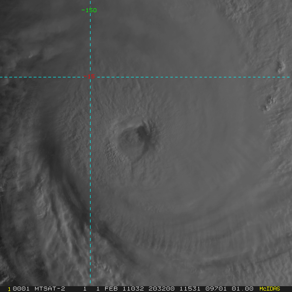
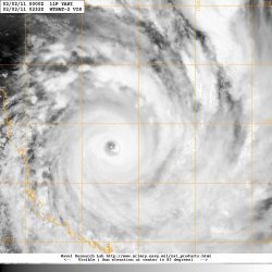
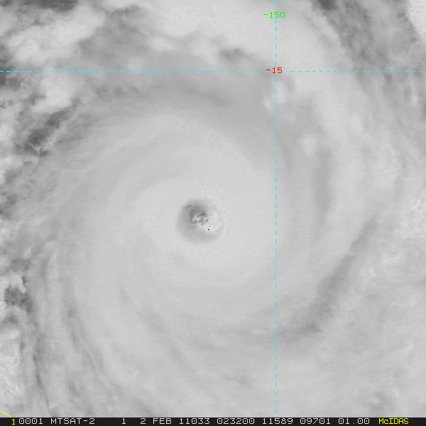
Still trying to cope with the worst flood event in its history, and now the worst cyclone " the weather bureau has never seen" is headed for the same place with still more torrential rains.

I mean the event itself is important outside of the issue of whether this is indicative of GW, is it not?

God! boys, give it a rest!


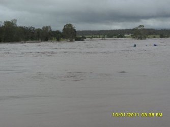
Indeed, here's my friends farm going under. Note the time stamps and just how fast the water came up. This is the Lockyer Creek overflowing.


Here's the final picture
 

Attachments

  • $securedownload3.jpg
    $securedownload3.jpg
    39.9 KB · Views: 66
Queensland has taken two massive hits. Enough so that the Australian government is considering a tax hike to aid in the rebuilding. That is a wise move.
 
Old Rocks thinks the fact that its Summer in Queensland is because of global warming.

Lower temps and more snow is because of global warming.

Higher temps and less snow is because of global warming.

Summer in Queensland when the biggest snowstorm in 40 years is rolling across the midwest is because of global warming.

Pro Bowl was moved to Hawaii because of global warming.

Old Rocks wouldn't know Science if it bit him in the ass, but he is an EXCELLENT Preacher!
 
2011SH11_1KMSRVIS_201102012032.GIF


TROPICAL CYCLONE ADVICE NUMBER 12
Issued by the Bureau of Meteorology, Brisbane
Issued at 7:54am EST on Wednesday the 2nd of February 2011

A Cyclone WARNING is current for island and coastal areas from Cape Melville to
Sarina, extending inland to Croydon and Richmond.

A Cyclone WATCH is current for the remaining tropical interior east of Camooweal
and north of Winton.

At 7:00 am EST Severe Tropical Cyclone Yasi, Category 5 was estimated to be
555 kilometres east of Cairns and 560 kilometres northeast of Townsville
moving west southwest at 30 kilometres per hour.

SEVERE TC YASI IS A LARGE AND VERY POWERFUL TROPICAL CYCLONE AND POSES AN
EXTREMELY SERIOUS THREAT TO LIFE AND PROPERTY WITHIN THE WARNING AREA,
ESPECIALLY BETWEEN CAIRNS AND TOWNSVILLE.

THIS IMPACT IS LIKELY TO BE MORE LIFE THREATENING THAN ANY EXPERIENCED DURING
RECENT GENERATIONS.

TC Yasi, CATEGORY 5, will continue to move in a west-southwesterly direction
during the day. The cyclone is expected to cross the coast in the Innisfail area
at about midnight.

Coastal residents within the warning area, and particularly between Cairns and
Ayr are specifically warned of an EXTREMELY DANGEROUS SEA LEVEL RISE
[i.e. storm tide] as the cyclone approaches, crosses the coast and moves inland.
The sea is likely to steadily rise up to a level which will be VERY DANGEROUSLY
above the normal tide, with EXTREMELY DAMAGING WAVES, STRONG CURRENTS and
FLOODING of low-lying areas extending some way inland. People living in areas
likely to be affected by this flooding should take measures to protect their
property as much as possible, and be prepared to follow instructions regarding
evacuation of the area if advised to do so by authorities.

DAMAGING WINDS with gusts to 90 km/hr that are currently developing on coastal
islands, are forecast to develop about the coast by late morning and about the
tropical interior overnight.

Between Cape Tribulation and Ingham these winds will become DESTRUCTIVE with
gusts in excess of 125km/hr during the afternoon and early evening and VERY
DESTRUCTIVE with gusts up to 300 km/hr between Cairns and Ingham during the
evening as the cyclone approaches and crosses the coast. These VERY DESTRUCTIVE
winds can also occur on the seaward side of hills to the north of the cyclone
and are also forecast to reach the Atherton Tablelands.

Winds are forecast to ease about the east coast during Thursday morning as the
cyclone moves inland.

FLOODING RAINS will develop from Cooktown to Sarina during the afternoon and
then extend inland overnight.
People between Cape Melville and Sarina, extending inland to Croydon and
Richmond should complete preparations quickly and be prepared to shelter in a
safe place.
- Boats and outside property should be secured.
- For cyclone preparedness and safety advice, visit Queensland's Disaster
Management Services website [www.disaster.qld.gov.au]
- For emergency assistance call the Queensland State Emergency Service [SES] on
132 500 [for assistance with storm damage, rising flood water, fallen trees on
buildings or roof damage].

People about the remaining tropical interior east of Camooweal and north of
Winton should consider what action they will need to take if the cyclone threat
increases.
- Information is available from your local government
- For cyclone preparedness and safety advice, visit Queensland's Disaster
Management Services website [www.disaster.qld.gov.au]
- For emergency assistance call the Queensland State Emergency Service [SES] on
132 500 [for assistance with storm damage, rising flood water, fallen trees on
buildings or roof damage].

Details of Severe Tropical Cyclone Yasi at 7:00 am EST:
.Centre located near...... 16.1 degrees South 150.9 degrees East
.Location accuracy........ within 20 kilometres
.Recent movement.......... towards the west southwest at 30 kilometres per hour
.Wind gusts near centre... 295 kilometres per hour
.Severity category........ 5
.Central pressure......... 922 hectoPascals


Please ensure that neighbours have heard and understood this message,
particularly new arrivals or those who may not fully understand English.

The next advice will be issued by 11:00 am EST Wednesday 02 February.

This warning is also available through TV and Radio Broadcasts; the Bureau's
website at Bureau of Meteorology - Home Page or call 1300 659 212 begin_of_the_skype_highlighting 1300 659 212 end_of_the_skype_highlighting. The Bureau and the State
Emergency Service would appreciate this warning being broadcast regularly.
 
WTPS31 PGTW 011500
MSGID/GENADMIN/NAVMARFCSTCEN PEARL HARBOR HI/JTWC//
SUBJ/TROPICAL CYCLONE 11P (YASI) WARNING NR 006//
RMKS/
1. TROPICAL CYCLONE 11P (YASI) WARNING NR 006
01 ACTIVE TROPICAL CYCLONE IN SOUTHPAC
MAX SUSTAINED WINDS BASED ON ONE-MINUTE AVERAGE
WIND RADII VALID OVER OPEN WATER ONLY
---
WARNING POSITION:
011200Z --- NEAR 14.9S 153.2E
MOVEMENT PAST SIX HOURS - 255 DEGREES AT 17 KTS
POSITION ACCURATE TO WITHIN 020 NM
POSITION BASED ON EYE FIXED BY SATELLITE
PRESENT WIND DISTRIBUTION:
MAX SUSTAINED WINDS - 120 KT, GUSTS 145 KT
WIND RADII VALID OVER OPEN WATER ONLY
RADIUS OF 064 KT WINDS - 040 NM NORTHEAST QUADRANT
050 NM SOUTHEAST QUADRANT
050 NM SOUTHWEST QUADRANT
040 NM NORTHWEST QUADRANT
RADIUS OF 050 KT WINDS - 090 NM NORTHEAST QUADRANT
100 NM SOUTHEAST QUADRANT
100 NM SOUTHWEST QUADRANT
090 NM NORTHWEST QUADRANT
RADIUS OF 034 KT WINDS - 180 NM NORTHEAST QUADRANT
200 NM SOUTHEAST QUADRANT
200 NM SOUTHWEST QUADRANT
180 NM NORTHWEST QUADRANT
REPEAT POSIT: 14.9S 153.2E
---
FORECASTS:
12 HRS, VALID AT:
020000Z --- 15.9S 149.7E
MAX SUSTAINED WINDS - 130 KT, GUSTS 160 KT
WIND RADII VALID OVER OPEN WATER ONLY
RADIUS OF 064 KT WINDS - 050 NM NORTHEAST QUADRANT
060 NM SOUTHEAST QUADRANT
060 NM SOUTHWEST QUADRANT
050 NM NORTHWEST QUADRANT
RADIUS OF 050 KT WINDS - 100 NM NORTHEAST QUADRANT
110 NM SOUTHEAST QUADRANT
110 NM SOUTHWEST QUADRANT
100 NM NORTHWEST QUADRANT
RADIUS OF 034 KT WINDS - 190 NM NORTHEAST QUADRANT
210 NM SOUTHEAST QUADRANT
210 NM SOUTHWEST QUADRANT
190 NM NORTHWEST QUADRANT
VECTOR TO 24 HR POSIT: 250 DEG/ 18 KTS
---
24 HRS, VALID AT:
021200Z --- 17.1S 146.2E
MAX SUSTAINED WINDS - 130 KT, GUSTS 160 KT
WIND RADII VALID OVER OPEN WATER ONLY
RADIUS OF 064 KT WINDS - 050 NM NORTHEAST QUADRANT
060 NM SOUTHEAST QUADRANT
060 NM SOUTHWEST QUADRANT
050 NM NORTHWEST QUADRANT
RADIUS OF 050 KT WINDS - 100 NM NORTHEAST QUADRANT
110 NM SOUTHEAST QUADRANT
110 NM SOUTHWEST QUADRANT
100 NM NORTHWEST QUADRANT
RADIUS OF 034 KT WINDS - 190 NM NORTHEAST QUADRANT
210 NM SOUTHEAST QUADRANT
210 NM SOUTHWEST QUADRANT
190 NM NORTHWEST QUADRANT
VECTOR TO 36 HR POSIT: 245 DEG/ 17 KTS
---
36 HRS, VALID AT:
030000Z --- 18.5S 143.0E
MAX SUSTAINED WINDS - 080 KT, GUSTS 100 KT
WIND RADII VALID OVER OPEN WATER ONLY
DISSIPATING AS A SIGNIFICANT TROPICAL CYCLONE OVER LAND
VECTOR TO 48 HR POSIT: 245 DEG/ 15 KTS
---
EXTENDED OUTLOOK:
48 HRS, VALID AT:
031200Z --- 19.7S 140.2E
MAX SUSTAINED WINDS - 045 KT, GUSTS 055 KT
WIND RADII VALID OVER OPEN WATER ONLY
DISSIPATING AS A SIGNIFICANT TROPICAL CYCLONE OVER LAND
VECTOR TO 72 HR POSIT: 245 DEG/ 12 KTS
---
72 HRS, VALID AT:
041200Z --- 21.7S 135.6E
MAX SUSTAINED WINDS - 030 KT, GUSTS 040 KT
WIND RADII VALID OVER OPEN WATER ONLY
DISSIPATED AS A SIGNIFICANT TROPICAL CYCLONE OVER LAND
---
REMARKS:
011500Z POSITION NEAR 15.2S 152.3E.
TROPICAL CYCLONE (TC) 11P (YASI), LOCATED APPROXIMATELY 450 NM EAST-
NORTHEAST OF CAIRNS, AUSTRALIA, HAS TRACKED WEST-SOUTHWESTWARD AT 17
KNOTS OVER THE PAST SIX HOURS. ANIMATED INFRARED SATELLITE IMAGERY
SHOWS A 10 NM EYE, FROM WHICH THE INITIAL POSITION WAS BASED. THE
INITIAL INTENSITY WAS BASED ON PGTW AND ABRF DVORAK ESTIMATES
RANGING FROM 115 TO 127 KNOTS. A POLEWARD OUTFLOW CHANNEL INTO AN
UPPER LEVEL LOW TO THE SOUTH, ALONG WITH GOOD EQUATORWARD OUTFLOW
HAS ALLOWED FOR RAPID INTENSIFICATION WITHIN THE PAST 12 HOURS. TC
11P IS CURRENTLY TRACKING ALONG THE NORTHERN PERIPHERY OF A DEEP
LAYER SUBTROPICAL STEERING RIDGE AND IS EXPECTED TO TRACK GENERALLY
WEST-SOUTHWESTWARD THROUGHOUT THE FORECAST PERIOD. THE SYSTEM SHOULD
CONTINUE TO INTENSIFY DUE TO EXCELLENT OUTFLOW, LOW VERTICAL WIND
SHEAR, AND FAVORABLE OCEANIC CONDITIONS. AROUND TAU 24, THE SYSTEM
IS FORECAST TO MAKE LANDFALL JUST SOUTH OF CAIRNS AND BEGIN
WEAKENING AS IT TRACKS INLAND. THE AVAILABLE NUMERICAL MODEL
GUIDANCE IS IN TIGHT AGREEMENT AND TRACK CONFIDENCE IS HIGH.
MAXIMUM SIGNIFICANT WAVE HEIGHT AT 011200Z IS 38 FEET. NEXT WARNINGS
AT 020300Z AND 021500Z.//
NNNN

The aussie system is based on max gust, but the jtwc is based off the one minute wind. Ivan 2004, Katrina 2005 at landfall, Andrew(1992) during its second landfall is comparable to this.
 
Last edited:
Queensland has taken two massive hits. Enough so that the Australian government is considering a tax hike to aid in the rebuilding. That is a wise move.


Mmmmmm, actually this is whats going around Oz at the moment!

THE TOP 8 RECIPIENTS OF THE AUSTRALIAN GOVERNMENT'S AID DOLLARS IN 2010-2011


Indonesia - $ 458.7 million

Papua New Guinea - $ 457.2 million

Solomon Islands - $ 225.7 million

Afghanistan - $ 123.1 million

Vietnam - $ 119.8 million

Philippines - $ 118.1 million

East Timor - $ 102.7 million

Cambodia - $ 64.2 million


TOTAL = $ 1,669 million -to be given away in 52 weeks


..but wait, there’s more... !!!!!!!


• Australia provides approximately 150,000 tonnes of food aid every year—about $65 million—to

Bangladesh , Indonesia , Sri Lanka , Sudan and Chad .


• In 2010-2011 the Australian Government plans to spend almost $4.4 billion on development assistance to under developed countries.


SO….. Ask your local Member how come 2011 Queensland flood victims get “$17 million so far”?


And now Gillard will give nearly $500 million for Indonesia’s Islamic schools which are largely moderate in outlook but there have been pockets of radicalism that have produced terrorists in Indonesia, most notably the cleric Abu Bakar Bashir’s school in Ngruki, central Java, where some of the Bali bombers studied


STOP THE OVERSEAS AID NOW AND DIVERT THOSE FUNDS TO

QUEENSLAND.


WHEN QUEENSLAND HAS BEEN REBUILT AND BACK ON ITS FEET,

THEN WE CAN HELP TO BUILD MORE ISLAMIC SCHOOLS OVERSEAS.


The people are pissed and rightly so. Australia is giving money away at a prodigous rate to foreign governemnts and screwing the citizenry. The citzenry are tired of it.
 
IDQP0005
Australian Government Bureau of Meteorology
Queensland
Tropical Cyclone Warning Centre

Media: Transmitters serving the area between Cape Melville to Sarina are
requested to USE the Standard Emergency Warning Signal before broadcasting the
following warning.

TOP PRIORITY
TROPICAL CYCLONE ADVICE NUMBER 13
Issued by the Bureau of Meteorology, Brisbane
Issued at 11:12am EST on Wednesday the 2nd of February 2011

A Cyclone WARNING is current for coastal and island communities from Cape
Melville to Sarina, extending inland to Croydon and Richmond.

A Cyclone WATCH is current for the remaining inland parts west to the Northern
Territory border and north of Winton.

At 10:00 am EST Severe Tropical Cyclone Yasi, Category 5 was estimated to be 445
kilometres east of Cairns and 455 kilometres northeast of Townsville and moving
west southwest at 30 kilometres per hour.

SEVERE TC YASI IS A LARGE AND VERY POWERFUL TROPICAL CYCLONE AND POSES AN
EXTREMELY SERIOUS THREAT TO LIFE AND PROPERTY WITHIN THE WARNING AREA,
ESPECIALLY BETWEEN CAIRNS AND TOWNSVILLE.

THIS IMPACT IS LIKELY TO BE MORE LIFE THREATENING THAN ANY EXPERIENCED DURING
RECENT GENERATIONS.

TC Yasi, CATEGORY 5, will continue to move in a west-southwesterly direction
during the day. The cyclone is expected to cross the coast in the Innisfail area
at about midnight.

Coastal residents within the warning area, and particularly between Cairns and
Ayr are specifically warned of an EXTREMELY DANGEROUS SEA LEVEL RISE [i.e. storm
tide] as the cyclone approaches, crosses the coast and moves inland. The sea is
likely to steadily rise up to a level which will be VERY DANGEROUSLY above the
normal tide, with EXTREMELY DAMAGING WAVES, STRONG CURRENTS and FLOODING of
low-lying areas extending some way inland. People living in areas likely to be
affected by this flooding should take measures to protect their property as much
as possible, and be prepared to follow instructions regarding evacuation of the
area if advised to do so by authorities.

DAMAGING WINDS with gusts to 90 km/hr that are currently developing on coastal
islands, are forecast to develop about the coast by late morning and about the
tropical interior overnight.

Between Cape Tribulation and Ingham these winds will become DESTRUCTIVE with
gusts in excess of 125km/hr during the afternoon and early evening and VERY
DESTRUCTIVE with gusts up to 300 km/hr between Cairns and Ingham during the
evening as the cyclone approaches and crosses the coast. These VERY DESTRUCTIVE
winds can also occur on the seaward side of hills to the north of the cyclone
and are also forecast to reach the Atherton Tablelands.

Winds are forecast to ease about the east coast during Thursday morning as the
cyclone moves inland.

FLOODING RAINS will develop from Cooktown to Sarina during the afternoon and
then extend inland overnight.
People between Cape Melville and Sarina, extending inland to Croydon and
Richmond should complete preparations quickly and be prepared to shelter in a
safe place.
- Boats and outside property should be secured.
- For cyclone preparedness and safety advice, visit Queensland's Disaster
Management Services website [www.disaster.qld.gov.au]
- For emergency assistance call the Queensland State Emergency Service [SES] on
132 500 [for assistance with storm damage, rising flood water, fallen trees on
buildings or roof damage].

People about the remaining inland parts west to the Northern Territory border
and north of Winton should consider what action they will need to take if the
cyclone threat increases.
- Information is available from your local government
- For cyclone preparedness and safety advice, visit Queensland's Disaster
Management Services website [www.disaster.qld.gov.au]
- For emergency assistance call the Queensland State Emergency Service [SES] on
132 500 [for assistance with storm damage, rising flood water, fallen trees on
buildings or roof damage].

Details of Severe Tropical Cyclone Yasi at 10:00 am EST:
.Centre located near...... 16.4 degrees South 149.9 degrees East
.Location accuracy........ within 30 kilometres
.Recent movement.......... towards the west southwest at 30 kilometres per hour
.Wind gusts near centre... 295 kilometres per hour
.Severity category........ 5
.Central pressure......... 922 hectoPascals


Please ensure that neighbours have heard and understood this message,
particularly new arrivals or those who may not fully understand English.

The next advice will be issued by 2:00 pm EST Wednesday 02 February.

This warning is also available through TV and Radio Broadcasts; the Bureau's
website at Bureau of Meteorology - Home Page or call 1300 659 212. The Bureau and the State
Emergency Service would appreciate this warning being broadcast regularly.

idq650019591075.gif


2011sh111kmsrvis2011020.gif


201102012211f18x91h11py.jpg
 
Largest Cyclone event in Australia since 1918.

QUEENSLAND, AUSTRALIA - CURRENT CYCLONE THREAT IMMINENT
Severe TC Yasi Cat5, extremely serious threat between Cairns and townsville.
TC Yasi Will landfall between Innisfail and Cardwell. Very high seas, and dangerous
Sea swells even down to the Sunshine coast. Gust up to 295klm/hr and some higher.
Higher tides up to 20 feet (6+1/2 to 7metres) Becoming more dangerous into the next 24hrs.
Sea levels building over a number of hours and height increasing with wave activity.
Mandatory Evac for all low lying areas.
Last chance to leave before rapidly moving water inundates stipulated storm flood areas.
Around Georgetown approx 9am tomorrow morning Cat 3 is expected.
Tablelands and hinterland and towns to the west will experience cyclonic conditions.
Cyclone has now passed over Willis Island. There is now no TC measuring equipment
from that location. All staff were evacuated. Power outages around Eire.
Some reports of large trees coming down in Eire. 9,000+ currently in Evac centres.
Evac by plane complete of all hospital dependent patients within next hour (by 1:30pm)
Winds currently around 95klm/hr in coastal regions.
Bureau of Meteorology - Home Page
 

Forum List

Back
Top