Mega Snow Storm Pic

Zoom-boing

Platinum Member
Oct 30, 2008
25,764
7,808
350
East Japip
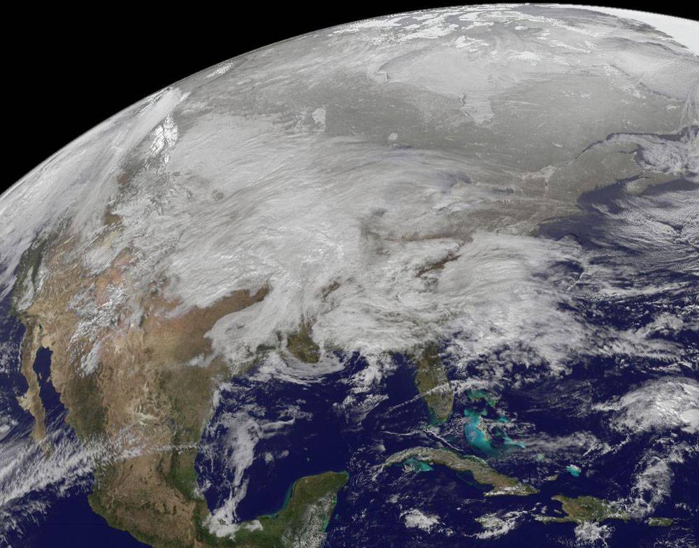
Satellite Shows Winter Megastorm Painting U.S. White
winter-storm-goes-13-nasa.jpg


A NASA photograph of the Midwest megastorm gives profound visual truth to what it means for a snowstorm to blanket the United States.

The image was captured from space Jan. 31 by the GOES 13 satellite, which regularly photographs the Eastern half of the planet from a geosynchronous altitude of about 22,000 miles.

Cold air from the north is diving southward and colliding with moist tropical air, covering one-third of the United States in clouds. The storm is expected to flow east and depart New England on Wednesday night.

Forecasters expect the storm will break snowfall records in the Great Plains and central Midwest. In the East, it may deliver ice storms that could cause $1 billion in damage. It’s the latest in a string of storms fitting a pattern predicted by climate scientists. Rising temperatures allow air to hold more moisture, loading storm systems with precipitation that’s ultimately dumped back on Earth.

Cooool.
 
Beautiful image, but so far, we have no unusual weather here in Cleveland. I'm beginning to wonder if this isn't a made up story.

Not here. There's already a foot out my front door, not in falling snow, but blown snow. this is not looking good.
 
Too warm here for snow, but we're expecting a few tornadoes overnight, and a butt-load of nasty storms. I'd rather have the snow :(
 
S Florida is cloudy and nice - but it's humid and getting moister, when the cold air gets here we are going to get some serious thunder-boomers!
 
Looks like we'll escape the tornadoes :)

The line really came together right as it hit us, and everyone East of us is now under severe T-storm and/or tornado watches/warnings (we're still under a watch, but the danger is past us).

This doesn't bode well for the Northeast, assuming it is eventually going to turn and head your way like almost everything that rolls through here this time of year. 2.58" of rain in less than an hour. Using the "1" rain = 6" snow" Farmer's Almanac formula, that's 15" snow :(
 
Snowing and blowing here... You can't see my house for the clouds. I've got the lights on so when the clouds move away, you will be able to see my house.
 
Pouring rain here tonight in the Knoxville area - supposed to get worse with high winds during the night. I think the snow will bypass us to the north.
 
It just started that freezing rain nonsense about 1/2 hour ago here. They're calling for 1/4" - 3/4" of ice. Cripes, it's windy too. As long as nothing crashes in, through or down . . . . You'd think the schools could make the executive decision tonight and push that auto-phone button, huh? Nah, 5a.m. wake up call. :rolleyes:
 
Well, we got about 1/2" of ice on everything but it's all changing over to rain now. Kids are off all day, again :rolleyes: and college kid (who was smart and came home yesterday afternoon) got to her internship just fine. Roads are just wet and it's all

meltingIcetechnology.jpg
 

Forum List

Back
Top