Mayan update

BDBoop

Platinum Member
Jul 20, 2011
35,384
5,459
668
Don't harsh my zen, Jen!
Scientists find ancient Mayan astronomy records, with hint the world won’t truly end this year - The Washington Post

Astronomical records were key to the Mayan calendar, which has gotten some attention recently because of doomsday warnings that it predicts the end of the world this December. Experts say it makes no such prediction. The new finding provides a bit of backup: The calculations include a time span longer than 6,000 years that could extend well beyond 2012.

“Why would they go into those numbers if the world is going to come to an end this year?” observed Anthony Aveni of Colgate University in Hamilton, N.Y., an expert on Mayan astronomy. “You could say a number that big at least suggests that time marches on.”

Well, that's a relief. For somebody, I'm sure.
 
56717276527377091_iL2XKPEi_f.jpg
 
Oldest Mayan calendar unearthed...
:eusa_eh:
Mayan art and calendar at Xultun stun archaeologists
10 May 2012 - The preservation of the artwork surprised archaeologists, given the dwelling's shallow depth
Archaeologists working at the Xultun ruins of the Mayan civilisation have reported striking finds, including the oldest-known Mayan astronomical tables. The site, in Guatemala, includes the first known instance of Mayan art painted on the walls of a dwelling. A report in Science says it dates from the early 9th Century, pre-dating other Mayan calendars by centuries. Such calendars rose to prominence recently amid claims they predicted the end of the world in 2012.

The Mayan civilisation occupied Central America from about 2000BC until its decline and assimilation following the colonisation by the Spanish from the 15th Century onwards. It still holds fascination, with many early Mayan sites still hidden or uncatalogued. The ruins at Xultun were first discovered in 1912 and mapping efforts in the 1920s and 1970s laid out much of the site's structure. Archaeologists have catalogued the site's features, including a 35m-tall pyramid, but thousands of structures on the 30 sq km site remain unexplored.

In 2005, William Saturno, then at the University of New Hampshire, discovered the oldest-known Mayan murals at a site just a few kilometres away called San Bartolo. in 2010, one of Dr Saturno's students was following the tracks of more recent looters at Xultun when he discovered the vegetation-covered structure that has now been excavated. When Mayans renovated an old structure, they typically collapsed its roof and built on top of the rubble. But for some reason, the new Xultun find had been filled in through its doorway, with the roof left intact.

Dr Saturno, who is now based at Boston University, explained that despite it being under just a metre of soil today, that served to preserve the site after more than a millennium of rainy seasons, insect traffic and encroaching plant and tree roots. "We found that three of the room's four walls were well preserved and that the ceilings were also in good shape in terms of the paintings on them, so we got an awful lot more than we bargained for," he said.

'Different mindset'

See also:

Apocalypse never: Newly discovered Mayan calendar further disproves doomsday myth
May 10, 2012 - Scientists have uncovered the oldest-known Mayan calendar ever discovered — and it further shows that all this December 21, 2012, apocalypse talk is a bunch of hooey.
The world is not going to end on December 21. No, not even according to the Mayan calendar. And especially not according to the awesome newly uncovered Mayan calendar — the oldest known Mayan calendar in existence — which was recently discovered by Boston University archeologist William Saturno. First glimpsed by an undergraduate student of Saturno’s in 2010, this new Mayan calendar was found buried at a well known Mayan archeology site in Guatemala. After first dismissing the value of the bit of paint spotted by his student, Saturno later went back to record the discovery, regardless of whether it had value.

What Saturno found turned out to be a well-presevered mural that includes the oldest known Mayan calendar to date. And just like the Maya Long Count calendar, which serves as the basis for the apocalypse myth, this calendar extends indefinitely into the future. “The Mayan calendar is going to keep going for billions, trillions, octillions of years into the future,” University of Texas archeologist, author, and Maya expert David Stuart told LiveScience. “Numbers we can’t even wrap our heads around.”

In case you’re stumbling upon the Mayan doomsday nonsense for the first time, here’s the gist of it: The Mayan calendar is broken down into “baktuns” (or “b’ak’tun”), each of which equals 400 years, or about 146,000 days. According to Mayan legend, the current world — the one in which we are all currently living — was created over 12 baktuns ago. At the end of the 13th baktun, the world as we know it will cease to exist. December 21, 2012 — the winter solstice — is that day.

Of course, many scientists with real understanding of ancient Mayan culture and language have for decades tried to explain that, no, the end of the 13th baktun does not literally mean the end of the world. In fact, they say, not even the Mayans themselves believed such silliness. The end-of-world myth was actually concocted by Christian missionaries. And some experts say that the end of the 13th baktun is actually December 23, not December 21. The newly discovered Mayan calendar has cycles of time recording 17 baktuns, rather than the standard 13. This and other details, which Saturno describe in this week’s issue of the journal Science, should be all anyone needs to stop their urge to stock up on canned food and ammo.

Read more: Apocalypse never: Newly discovered Mayan calendar further disproves doomsday myth
 
What about those of us who ALREADY satisfied the urge to stock up on canned goods, and ammo?
 
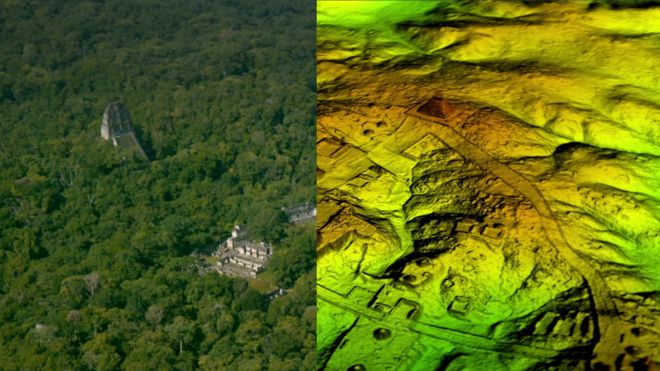
Lasers find lost Mayan cities...
cool.gif

Sprawling Maya network discovered under Guatemala jungle
2 February 2018 - Researchers have found more than 60,000 hidden Maya ruins in Guatemala in a major archaeological breakthrough.
Laser technology was used to survey digitally beneath the forest canopy, revealing houses, palaces, elevated highways, and defensive fortifications. The landscape, near already-known Maya cities, is thought to have been home to millions more people than other research had previously suggested. The researchers mapped over 810 square miles (2,100 sq km) in northern Peten. Archaeologists believe the cutting-edge technology will change the way the world will see the Maya civilisation. "I think this is one of the greatest advances in over 150 years of Maya archaeology," said Stephen Houston, Professor of Archaeology and Anthropology at Brown University.

_99859938_mixmayanpic.png

The Maya city of Tikal was found to be just a fraction of an immense hidden metropolis​

Mr Houston told the BBC that after decades of work in the archaeological field, he found the magnitude of the recent survey "breathtaking". He added, "I know it sounds hyperbolic but when I saw the [Lidar] imagery, it did bring tears to my eyes." Results from the research using Lidar technology, which is short for "light detection and ranging", suggest that Central America supported an advanced civilisation more akin to sophisticated cultures like ancient Greece or China. "Everything is turned on its head," Ithaca College archaeologist Thomas Garrison told the BBC. He believes the scale and population density has been "grossly underestimated and could in fact be three or four times greater than previously thought".

How does Lidar work?

Described as "magic" by some archaeologists, Lidar unveils archaeological finds almost invisible to the naked eye, especially in the tropics.

* It is a sophisticated remote sensing technology that uses laser light to densely sample the surface of the earth
* Millions of laser pulses every four seconds are beamed at the ground from a plane or helicopter
* The wavelengths are measured as they bounce back, which is not unlike how bats use sonar to hunt
* The highly accurate measurements are then used to produce a detailed three-dimensional image of the ground surface topography

Revolutionary treasure map

That is some cool stuff. Mayans were indeed interesting peoples; some still are. I think many people don't really get how dense those jungles are in Central America, or in Brazil and other places in South America, either, including mountain ranges. No telling what is left to find out there, probably a lot more than has already been found.
 

Forum List

Back
Top