Inconvenient historic (climate alarmism) facts

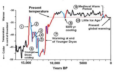
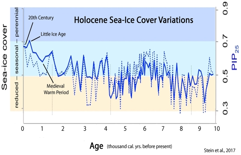
Take a look at your graph skidmark...and then look at this one and tell me how anyone other than an idiot could believe that what we are seeing is anything more than a slight dip....look on further back and you see what real ice loss looks like...and you also see that the world, and the sea life, and everything else survived it just fine....the sky didn't fall and the world didn't come to an end....things just moved on...business as usual in a chaotic system.

Your incessant cries of doom, and your misplaced blame puts you up on the top shelf with all the other top shelf dupes. Look at the big picture you idiot and see how irrelevant, and dishonest your eyeblink view is.

Let me know when the ice drops to below the levels of 8000 or 9000 years ago...then at least we will be at the limits of natural variability for the past 10,000 years...then we can look at an even larger picture and see that ice at both of the poles is the anomaly on earth...not the norm.


Arctic-Sea-Ice-Holocene-Stein-17.jpg

He continues to IGNORE the NULL Hypothesis.
 
2015-01-27_08-35-48_web.jpg

At the time the St Roch navigated the NWP pack ice like this was reported as solid ice cover. I have doubts that satellite observations would classify it as "solid" today considering the amount of water visible in the picture taken by a crew member of the St. Roch. It turned out not to be an obstacle as a solid ice cover would have been, because soon after that picture was taken the winds kicked up and and it was clear sailing to Herschel Island to unload fuel and other supplies. Bottom line is that actual historical records do not support what has been published as "solid" ice extent on these fact-faking graphs for the same time period. The fact that the "solid ice" vanished as soon as the wind kicked up is swept under the rug by the methods which are used today. Either by burying it in an average or cherry-picking a satellite view time frame when the ice floes where closer together.
 
From NSIDC.org

What is sea ice extent, and why do you monitor that particular aspect of sea ice?
Sea ice extent is a measurement of the area of ocean where there is at least some sea ice. Usually, scientists define a threshold of minimum concentration to mark the ice edge; the most common cutoff is at 15 percent. Scientists use the 15 percent cutoff because it provides the most consistent agreement between satellite and ground observations.

Your photo is obviously well beyond 15% coverage.

Oy
He has no clue about PACK ICE and how its dynamics can change in literally minuets...
And he chose to ignore that it was not just beyond the 15% but almost zero shortly after this photo was taken.
Photographers ( including this one) prefer to take pictures of the unusual. They don`t waste their time & efforts to snap for example a picture of open road and smooth going but will document an accident & a traffic jam. The St Roch proceeded shortly after that picture was taken to the shore line visible in the photo but no photo was taken then because everything was back to normal.It is almost 100% predictable how alarmists like Crick etc will choose what they see in a Rorschach test and always turn a blind eye to what else was there.
I have seen myself how quickly "solid ice" can vanish when I was in Thule and at CFS Alert. Same thing in Churchill Manitoba. Eco activist-tourist-"reporters" document open water and "stranded" polar bears every time the Nelson river dams open their spillway gates and the ice gets displaced for a short period of time. But as soon as the gates close and the ice is back none of them are there to take any pictures. They are all gone to upload and publish their "evidence" on the kind of click-bait blogs that Crick, Old Rocks etc post here incessantly.
 
From NSIDC.org

What is sea ice extent, and why do you monitor that particular aspect of sea ice?
Sea ice extent is a measurement of the area of ocean where there is at least some sea ice. Usually, scientists define a threshold of minimum concentration to mark the ice edge; the most common cutoff is at 15 percent. Scientists use the 15 percent cutoff because it provides the most consistent agreement between satellite and ground observations.

Your photo is obviously well beyond 15% coverage.

Oy
He has no clue about PACK ICE and how its dynamics can change in literally minuets...


Who is "he"? That statement is from the NSIDC and accurately represents the common practice of ice science. In this instance it would quite obviously be YOU who hasn't a clue.
 

Forum List

Back
Top