I wonder why the arctic data is so skewed?

westwall

WHEN GUNS ARE BANNED ONLY THE RICH WILL HAVE GUNS
Gold Supporting Member
Apr 21, 2010
96,359
57,451
2,605
Nevada
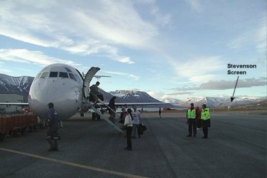
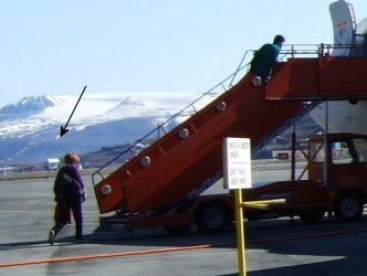
Ever wonder how GISS gets such ridiculous temperature data? Well here is one of their methods. The weather station of Svalbard is a good example. Here you are in the middle of nowhere and where do they site the station.........? why right next to 9 acres of asphalt of course!

0 km (*) Svalbard Luft 78.2 N 15.5 E 634010080002 rural area 1977–2006

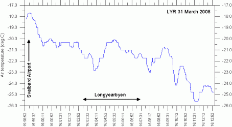
Below are two photo's of the weather station and a graph showing the dramatic urban heat island effect as you move away from the airport....and old fraud actually believes this crap!
 

Attachments

  • $screen_on_tarmac1.jpg
    $screen_on_tarmac1.jpg
    35.5 KB · Views: 117
  • $screen_on_tarmac3.jpg
    $screen_on_tarmac3.jpg
    41.7 KB · Views: 112
  • $LYR%20UrbanHeatIsland%2020080331.gif
    $LYR%20UrbanHeatIsland%2020080331.gif
    9.9 KB · Views: 105
Ah yes, the vast conspriracy to report false data. Worse yet, the bastards are out there also melting the Arctic Ice and Permafrost, just to make it look like they are correct.

Damn, Walleyed, do you need anymore foil for your hats?

You might note that we are not the only people measureing the temps there. All the polar nations are, using both ground and satellite data. If there were significant deviations in the data, we would here about it. Just as when our satellite sensor began to report bad temps, we compared it to the ESA satellite reports, and corrected the problem.
 
  • Thread starter
  • Banned
  • #3
Ah yes, the vast conspriracy to report false data. Worse yet, the bastards are out there also melting the Arctic Ice and Permafrost, just to make it look like they are correct.

Damn, Walleyed, do you need anymore foil for your hats?

You might note that we are not the only people measureing the temps there. All the polar nations are, using both ground and satellite data. If there were significant deviations in the data, we would here about it. Just as when our satellite sensor began to report bad temps, we compared it to the ESA satellite reports, and corrected the problem.


Sorry old chum but the various governmental reporting agencies use the same stations and they keep dropping out the ones that give non inflated data like this ridiculous example.
Below is a link to a group that moniters the AGW shenanigans with the surface stations. If a private business were doing this sort of BS the owners would be in jail. It might surprise you that the AGW fraudsters use a SINGLE station to cover a 1200 kilometer stretch of open land....care to guess where it is sited? Yep old fraud right in the only town in that area.

I don't need a foil hat to assert these things old fraud your side has done it for me!

Home
 

Forum List

Back
Top