How the States Got Their Shapes

That's the western side!


Oops! How careless of me.

That was my Keystoner perspective getting me into trouble.

As a former PA resident who lived alongside the Delaware River I associate the Garden State as East.

Yeah, X, sorta like that.

Only I see the what you've made the nose more of the brow ridge, and the next largest proturberance as the nose and the much smaller lowest protuberance as the lips.
 
Below is a map drawn by Thomas Jefferson; This was his ideal map of the new lands west of the original 13 states.

At the bottom of the map are the words “Here we see Thomas Jefferson’s plan for the division of the states West of the Appalachians; this would become the foundation for further expansion.” Of course reality of international relations, geography, practical limitations would interfere with his ideal plan. I think it’s interesting that his division produced states in the middle range of size as compared to the original ones, and except for those in the south, and present day Ohio bear little resemblance to the end result. It appears to me that Jefferson most had economics in mind, and the economics of geography is the facility of transportation which has always been access to navigable waters. At that time rivers as small as the Wabash were considered to be navigable rivers.

map.jpg


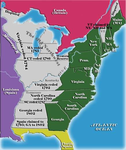
His was a departure from the original scheme of the colony’s claim of “western lands” or their western reserves. It was claimed that the “landed” states had a great potential advantage over the six “landless” states, so that the landless states projected their latitudinal boundaries westward beyond the colonies to lay a future claim.

“It was assumed that the future sale of western lands would enrich the landed states and possibly allow them to operate without any form of taxation. The landless states feared that they would lose residents and dwindle into insignificance.”

land-claims.jpg


Click HERE to read more on the Western Land Reserves
 
Last edited:
Below is a map drawn by Thomas Jefferson; This was his ideal map of the new lands west of the original 13 states.

At the bottom of the map are the words “Here we see Thomas Jefferson’s plan for the division of the states West of the Appalachians; this would become the foundation for further expansion.” Of course reality of international relations, geography, practical limitations would interfere with his ideal plan. I think it’s interesting that his division produced states in the middle range of size as compared to the original ones, and except for those in the south, and present day Ohio bear little resemblance to the end result. It appears to me that Jefferson most had economics in mind, and the economics of geography is the facility of transportation which has always been access to navigable waters. At that time rivers as small as the Wabash were considered to be navigable rivers.

map.jpg


His was a departure from the original scheme of the colony’s claim of “western lands” or their western reserves. It was claimed that the “landed” states had a great potential advantage over the six “landless” states, so that the landless states projected their latitudinal boundaries westward beyond the colonies to lay a future claim.

“It was assumed that the future sale of western lands would enrich the landed states and possibly allow them to operate without any form of taxation. The landless states feared that they would lose residents and dwindle into insignificance.”

land-claims.jpg


Click HERE to read more on the Western Land Reserves

Along those same lines is the book Lost States. I just purchased that book as well and it looks to be very interesting.

lost-states-book.jpg
 
I'm interested in finding out how Hawaii got it's shape.


no shit. Hawaii is basically a stubborn pimple on the earth that has been around for hundreds of millions of years. the new pus forms a new island and the old pus flakes off and the old islands disappear back into the ocean.
 
Along those same lines is the book Lost States. I just purchased that book as well and it looks to be very interesting.

lost-states-book.jpg

That is an interesting map, and includes two states of primary interest; "Franklin" occupied the section of N.C. that would become the "Great Smoky Mountains Ntl Pk", and 8-counties in eastern Tennessee . North Carolinians are well aware that that was actually in effect for a while, as an area contested for settlement with the indians.

"Lincoln" overlapping Oregon, Washington, and Idaho has to be an anomaly (thus spurious), since that could only post-date 1865 or thereabouts, and Oregon became a state in 1859.

Except for that anomaly, a book like that would have to contain a wealth of very interesting information

The history on "Franklin"
" ... The State of Franklin was set up in 1784 out of the westerly portion of the colonial state of North Carolina. Shortly after the War of Independence the original colonies were asked to pay for the war efforts and create a country with a sound financial policy. Since the taxing the population was difficult and cash was in short supply North Carolina ceded the western portion of the state to the federal coffers.

Before the Congress could accept the offer North Carolina withdrew the offer. The citizens of the region decided that federal rule in the meantime was probably a good idea since North Carolina as a state had given this remote region little support in its fight with the Indians or protection from criminal refugees. They saw other benefits as an independent state in terms of taxation, representation and an understanding attitude toward local problems. Representatives of the North Carolina counties of Sullivan, Washington, Greene, and Davidson accepted the offer of cessation to federal territory. The state of Franklin existed for only four years to finally merge with the new state of Tennessee. ... "
 
Last edited:
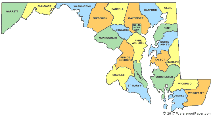
The single most bizarre shaped state is Maryland.

maryland-county-map.gif


Who thought of this? Is it all the counties that Pennsylvania, New Jersey and Virginia didn't want?

It was founded on a royal charter like most of the others. It got its final shape when the Mason-Dixon line was surveyed to end land squabbles between the colonies and MD simply became the land between it and the Potomac River out to where VA began, now WV.

I knew it was something odd like that. Thanks.
 
Why are there two Dakotas?

Because in the 12 degrees of latitude between 37 and 49, the wanted to divide it equally...thus each of the 4 plains states (ND, SD, NE, KS) is 3 degrees of latitude high.

I heard that it was divided because the Republican party was dominant there, so they decided to split it and get 4 senators instead of two. If it were all about latitude, why wasn't Minnesota split. It's the same N-S size?

You can tell there's a flaw in that explanation when you consider that if the Dakotas were one state they would be the largest states thus far created. Xo has it right, it's because it was decided to divide that row of states in 3-degree heights fom Oklahoma to Canada.


Consider, that decision also determined the north line of Oklahoma and caused the Oklahoma "panhandle" to be created.
In turn Oklahoma's line determined New Mexico's, Arizona's, Colorado's, and Utah's common boundary.
Here are the range of lattitudes:
Oklahoma North line 37°
Kansas 37° to 40° N
Nebraska 40° to 43°N
S. Dakota 43 °to 45.93° N
N. Dakota 45.93° to 49° N
 
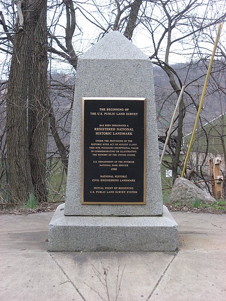
The POB or Point of Beginning is in my hometown. All the quadrilateral survey done in all the states west of Pennsylvania own my hometown a tip of the hat because all those surveys are based on a point at the northernmost point of the Ohio River opposite the northernmost point of what was once Virginia and the eastern border of the Northwest Territory which now is comprised of Ohio, Indiana, Illinois and that state up north!


450px-Beginning_Point_of_the_U.S._Public_Land_Survey_front.jpg
 
Last edited:
Because in the 12 degrees of latitude between 37 and 49, the wanted to divide it equally...thus each of the 4 plains states (ND, SD, NE, KS) is 3 degrees of latitude high.

I heard that it was divided because the Republican party was dominant there, so they decided to split it and get 4 senators instead of two. If it were all about latitude, why wasn't Minnesota split. It's the same N-S size?

You can tell there's a flaw in that explanation when you consider that if the Dakotas were one state they would be the largest states thus far created. Xo has it right, it's because it was decided to divide that row of states in 3-degree heights fom Oklahoma to Canada.


Consider, that decision also determined the north line of Oklahoma and caused the Oklahoma "panhandle" to be created.
In turn Oklahoma's line determined New Mexico's, Arizona's, Colorado's, and Utah's common boundary.
Here are the range of lattitudes:
Oklahoma North line 37°
Kansas 37° to 40° N
Nebraska 40° to 43°N
S. Dakota 43 °to 45.93° N
N. Dakota 45.93° to 49° N

Excerpt from Wikipdeia:

The territorial capital was Yankton from 1861 until 1883, when it was moved to Bismarck. Dakota Territory was divided into the states of North Dakota and South Dakota on November 2, 1889. The admission of two states, as opposed to one, was done for a number of reasons. The two population centers in the territory were in the northeast and southeast corners of the territory, several hundred miles away from each other. On a national level, there was pressure from the Republican Party to admit two states to add to their political power in the Senate.

Dakota Territory - Wikipedia, the free encyclopedia
 
The POB or Point of Beginning is in my hometown. All the quadrilateral survey done in all the states west of Pennsylvania own my hometown a tip of the hat because all those surveys are based on a point at the northernmost point of the Ohio River opposite the northernmost point of what was once Virginia and the eastern border of the Northwest Territory which now is comprised of Ohio, Indiana, Illinois and that state up north!


450px-Beginning_Point_of_the_U.S._Public_Land_Survey_front.jpg

That's cool.

My town contains the Center of the Universe. This is the point around which everything in the entire universe revolves.

In fact, it is located right at my house.
 
Excerpt from Wikipdeia:

The territorial capital was Yankton from 1861 until 1883, when it was moved to Bismarck. Dakota Territory was divided into the states of North Dakota and South Dakota on November 2, 1889. The admission of two states, as opposed to one, was done for a number of reasons. The two population centers in the territory were in the northeast and southeast corners of the territory, several hundred miles away from each other. On a national level, there was pressure from the Republican Party to admit two states to add to their political power in the Senate.

Dakota Territory - Wikipedia, the free encyclopedia

The territories were all subdivided: The NW territory was renamed the Indiana Territory, with the statehood of Ohio. the Indiana Territory was reduced in 1805 by the creation of the Michigan Territory, and in 1809 by the creation of the Illinois Territory. As your Wiki link alludes to, that sort of subdivision seemed to be a result of problems of managing large geographic areas. Soon after the creation of the Indiana Territory, the territorial governor Wm H. Harrison reported that the whole territory was unmanageble from a single capital, and he called for the building of a "highway" from Cincinatti to Vincennes, the Indiana territorial capital, and another capital in Michigan accessible from lakes Huron, Erie, and Michigan.

Subsequently the Illinois Territory, produced from the Indiana Territory was subdivided into all of or parts of Illinois, Wisconsin, and Minnesota, but not before part of that territory would become a part of the Michigan territory, after the statehoold of Illinois.
Illinoisterritory.PNG


That was the standing operating procedure. A Dakota territory left in one piece would've been a departure from all past experience and would've been larger than all the Illinois territory which became 3 states. Therefore the influence of the Republican Party in statehood affairs seems to be one political interpretaton of events.
 
Last edited:
Excerpt from Wikipdeia:

The territorial capital was Yankton from 1861 until 1883, when it was moved to Bismarck. Dakota Territory was divided into the states of North Dakota and South Dakota on November 2, 1889. The admission of two states, as opposed to one, was done for a number of reasons. The two population centers in the territory were in the northeast and southeast corners of the territory, several hundred miles away from each other. On a national level, there was pressure from the Republican Party to admit two states to add to their political power in the Senate.

Dakota Territory - Wikipedia, the free encyclopedia

The territories were all subdivided: The NW territory was renamed the Indiana Territory, with the statehood of Ohio. the Indiana Territory was reduced in 1805 by the creation of the Michigan Territory, and in 1809 by the creation of the Illinois Territory. As your Wiki link alludes to, that sort of subdivision seemed to be a result of problems of managing large geographic areas. Soon after the creation of the Indiana Territory, the territorial governor Wm H. Harrison reported that the whole territory was unmanageble from a single capital, and he called for the building of a "highway" from Cincinatti to Vincennes, the Indiana territorial capital, and another capital in Michigan accessible from lakes Huron, Erie, and Michigan.

Subsequently the Illinois Territory, produced from the Indiana Territory was subdivided into all of or parts of Illinois, Wisconsin, and Minnesota, but not before part of that territory would become a part of the Michigan territory, after the statehoold of Illinois.
Illinoisterritory.PNG


That was the standing operating procedure. A Dakota territory left in one piece would've been a departure from all past experience and would've been larger than all the Illinois territory which became 3 states. Therefore the influence of the Republican Party in statehood affairs seems to be one political interpretaton of events.

The population and land size arguments, I see as convenient excuses. The extra senators were THE REASON.
 
the REAL mystery is why the MI UP isn't part of WI?!?!
While still a territory Michigan and the state of Ohio disagreed about an area of land called the Toledo Strip, about 468 square miles in area, with both claiming sovereignty over it. The Michigan territory, after Illinois became a state was added onto including the area of future Wisconsin and the upper peninsula.

During this period the Michigan Territory got itself into a financial crisis, and at the same time the territorial government was under pressure to give the Toledo Strip to the state of Ohio.

Michigan applied for statehood and the congress and president Jackson made them an offer in the form of a resolution; give up the Toledo strip to Ohio and acquire the western three fourths of the upper pennsula as part of becoming the new state of Michigan.

The deal was struck, and it was generally believed that Ohio had won the "Toledo War" as the disagreement was called. But the mineral wealth that was discovered in the UP made that victory moot within a decade.
 
Last edited:

Forum List

Back
Top