Navigation
Install the app
How to install the app on iOS
Follow along with the video below to see how to install our site as a web app on your home screen.

Note: This feature currently requires accessing the site using the built-in Safari browser.
More options
You are using an out of date browser. It may not display this or other websites correctly.
You should upgrade or use an alternative browser.
You should upgrade or use an alternative browser.
Global Warming
- Thread starter BDBoop
- Start date


Granny don't like it when it gets hot - makes it hard for her to cut the grass...

Warming to Worsen Dead Zones, Algae Blooms Choking US Waterways
July 27, 2017 | WASHINGTON — Projected increases in rain from global warming could further choke U.S. waterways with fertilizer runoff that trigger dead zones and massive algae blooms, a new study said.
See also:
Climate Change Up Close: Southern, Poor US Counties to Suffer
June 29, 2017 - Poor and southern U.S. counties will get hit hardest by global warming, according to a first-of-its-kind detailed projection of potential climate change effects at the local level.
Related:
Researchers to See How Much Carbon Dioxide Forests Can Take
June 21, 2017 — Researchers at a British University have embarked on a decade-long experiment that will pump a forest full of carbon dioxide to measure how it copes with rising levels of the gas, a key driver of climate change.
Warming to Worsen Dead Zones, Algae Blooms Choking US Waterways
July 27, 2017 | WASHINGTON — Projected increases in rain from global warming could further choke U.S. waterways with fertilizer runoff that trigger dead zones and massive algae blooms, a new study said.
If greenhouse gas emissions keep rising, more and heavier rain will increase nitrogen flowing into lakes, rivers and bays by about 19 percent by the end of the century, according to a study in Thursday's journal Science. While that may not sound like much, many coastal areas are already heavily loaded with nitrogen. Researchers calculated that an extra 860,000 tons of nitrogen yearly will wash into American waterways by century's end.
The nutrients create low-oxygen dead zones and harmful blooms of algae in the Gulf of Mexico, Great Lakes, Pacific Northwest and Atlantic coast. "Many of these coastal areas are already suffering year-in, year-out from these dead zones and algal blooms,'' said one of the researchers, Anna Michalak, an ecologist at the Carnegie Institution for Science at Stanford University. "And climate change will make it all worse.''
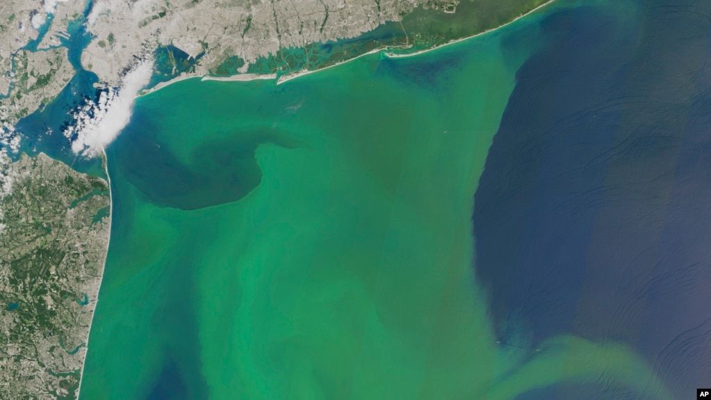
In this image provided by NASA, taken Aug. 3, 2015, phytoplankton is seen off the coast of New York, top and New Jersey, left.
When waterways are overloaded with nutrients, algae growth can run amok, creating dead zones. Algae can also choke waterways with "green mats of goop on top of the water'' that are giant floating blooms, Michalak said. The blooms often have toxins that can pollute drinking water. In 2014, a bloom on Lake Erie fouled tap water for half a million people in Toledo, Ohio, for more than two days.
The study, which is based on computer simulations, found the Northeast and Midwest will be hit hardest by the increase in nitrogen runoff. Most of the excess nitrogen from fertilizer use and the burning of coal, oil and gas would flow into the Mississippi River system and into the Gulf of Mexico, one of the largest dead zones on Earth, researchers said. "The results are incredibly interesting and compelling,'' said Samantha Joye, a University of Georgia marine sciences professor who wasn't part of the team.
Warming to Worsen Dead Zones, Algae Blooms Choking US Waterways
See also:
Climate Change Up Close: Southern, Poor US Counties to Suffer
June 29, 2017 - Poor and southern U.S. counties will get hit hardest by global warming, according to a first-of-its-kind detailed projection of potential climate change effects at the local level.
The study, published Thursday in the journal Science, calculates probable economic harms and benefits for the more than 3,100 counties in the United States under different possible scenarios for worldwide emissions of heat-trapping gases. It looks at agriculture, energy costs, labor costs, coastal damage from rising seas, crime and deaths, then estimates the effect on average local income by the end of the century. Researchers computed the possible effects of 15 types of impacts for each county across 29,000 simulations.
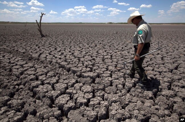
Texas State Park police officer Thomas Bigham walks across the cracked lake bed of O.C. Fisher Lake, in San Angelo, Texas
"The south gets hammered and the north can actually benefit," said study lead author Solomon Hsiang, a University of California economist. "The south gets hammered primarily because it's super-hot already. It just so happens that the south is also poorer." The southern part of the nation's heartland — such as Missouri, Kansas, Oklahoma, Arkansas, Kentucky and southern Illinois — also feels the heat hard, he said. Michigan, Minnesota, the far northeast, the northwest and mountainous areas benefit the most.
Counties hit hardest
The county hit hardest if greenhouse gas emissions continue unabated is tiny and impoverished Union County in Florida, where median income would take a 28 percent hit. And among counties with at least 500,000 people, Polk County in central Florida would suffer the most, with damages of more than 17 percent of income. Seven of the 10 counties with the highest percentage of projected county income losses from climate change are in Florida, along with two in Texas and one in Georgia. Half of these are among the poorest counties in the country.

A woman wipes her face with a cold wet towel to cool off while working outside in Las Vegas
Seven of the 10 counties with the highest percentage of projected county income losses from climate change are in Florida, along with two in Texas and one in Georgia. Half of these are among the poorest counties in the country. Five of the 10 counties that would benefit the most from global warming are in Michigan. The others are in Alaska, Colorado, Nevada and the mountainous region of North Carolina. Mineral County in Nevada would see a 13 percent increase in income, while Tacoma, Washington's Pierce County would benefit by about 2 percent, the most among counties with a population of more than 500,000.
MORE
Related:
Researchers to See How Much Carbon Dioxide Forests Can Take
June 21, 2017 — Researchers at a British University have embarked on a decade-long experiment that will pump a forest full of carbon dioxide to measure how it copes with rising levels of the gas, a key driver of climate change.
The Free Air Carbon Dioxide Enrichment (FACE) experiment at the University of Birmingham’s Institute of Forest Research (BIFoR) will expose a fenced-off section of mature woodland in Norbury Park in Staffordshire, West Midlands, to levels of CO2 that experts predict will be prevalent in 2050. Scientists aim to measure the forest’s capacity to capture carbon released by fossil fuel burning, and answer questions about their capacity to absorb carbon pollution long-term. “[Forests] happily take a bit more CO2 because that’s their main nutrient. But we don’t know how much more and whether they can do that indefinitely,” BIFoR co-director Michael Tausz told Reuters.
Carbon dioxide record
The apparatus for the experiment consists of a series of masts built into six 30-meter-wide sections of woodland, reaching up about 25 meters into the forest canopy. Concentrated CO2 is fed through pipes to the top of the masts where it is pumped into the foliage.
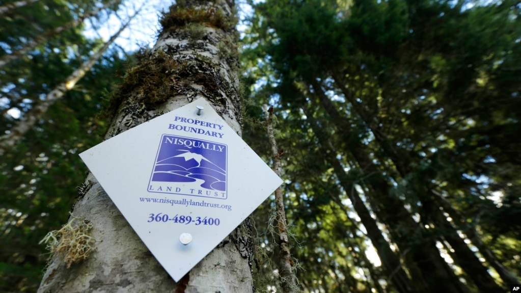
A project in Washington state is ensuring that forest land remains intact around Mount Rainier National Park, so the trees can continue to grow and store carbon dioxide emissions. In England, researchers are testing how much carbon dioxide trees can take.
Last year the U.N World Meteorological Organization (WMO) announced that the global average of carbon dioxide, the main man-made greenhouse gas, reached 400 parts per million (ppm) in the atmosphere for the first time on record. “The forest here sees nearly 40 percent more CO2 than it sees normally, because that’s what it will be globally in about 2050; a value of 550 parts per million, compared to 400 parts per million now,” Tausz said.
Deforestation
With deforestation shrinking the carbon storage capacity of the world’s forests, researchers hope that a greater understanding of their role in climate change mitigation could help policymakers make informed decisions. “We could get a clear idea of whether they can keep helping us into the future by sucking up more CO2,” Tausz said. The remainder of the Norbury Park woodland is open to the public and will not be affected by the experiment.
Researchers to See How Much Carbon Dioxide Forests Can Take
Arctic voyage finds global warming impact on ice, animals...

Arctic voyage finds global warming impact on ice, animals
Aug 14,`17 -- The email arrived in mid-June, seeking to explode any notion that global warming might turn our Arctic expedition into a summer cruise. "The most important piece of clothing to pack is good, sturdy and warm boots. There is going to be snow and ice on the deck of the icebreaker," it read. "Quality boots are key."
The Associated Press was joining international researchers on a month-long, 10,000 kilometer (6,200-mile) journey to document the impact of climate change on the forbidding ice and frigid waters of the Far North. But once the ship entered the fabled Northwest Passage between the Atlantic and the Pacific, there would be nowhere to stop for supplies, no port to shelter in and no help for hundreds of miles if things went wrong. A change in the weather might cause the mercury to drop suddenly or push the polar pack into the Canadian Archipelago, creating a sea of rock-hard ice. So as we packed our bags, in went the heavy jackets, insulated trousers, hats, mittens, woolen sweaters and the heavy, fur-lined boots. Global warming or not, it was best to come prepared.
---
Learn more about the Arctic and read dispatches sent by a team of AP journalists as they traveled through the region's fabled Northwest Passage last month: Associated Press News
---
If parts of the planet are becoming like a furnace because of global warming, then the Arctic is best described as the world's air-conditioning unit. The frozen north plays a crucial role in cooling the rest of the planet while reflecting some of the sun's heat back into space. Yet for several decades, satellite pictures have shown a dramatic decline in Arctic sea ice that is already affecting the lives of humans and animals in the region, from Inuit communities to polar bears. Experts predict that the impact of melting sea ice will be felt across the northern hemisphere, altering ocean currents and causing freak weather as far south as Florida or France. "Things are changing in the Arctic, and that is changing things everywhere else," said David 'Duke' Snider, the seasoned mariner responsible for navigating the Finnish icebreaker MSV Nordica through the Northwest Passage last month.

Researcher Tiina Jaaskelainen points out a possible sighting of wildlife aboard the Finnish icebreaker MSV Nordica as it traverses the Northwest Passage through the Canadian Arctic Archipelago, Saturday, July 22, 2017. As the icebreaker entered Victoria Strait, deep inside the Northwest Passage, those onboard looked for a shadow moving in the distance or a flash of pale yellow in the expanse of white that would signal the presence of the world's largest land predator.
Researchers on the trip sought a first-hand view of the effects of global warming already seen from space. Even the dates of the journey were a clue: The ship departed Vancouver in early July and arrived in Nuuk, Greenland on July 29th, the earliest transit ever of a region that isn't usually navigable until later in the year. As it made its way through the North Pacific - passing Chinese cargo ships, Alaskan fishing boats and the occasional far-off whale - members of the expedition soaked up the sun in anticipation of freezing weeks to come. Twelve days after the ship had left Vancouver, the ice appeared out of nowhere.
At first, lone floes bobbed on the waves like mangled lumps of Styrofoam. By the time Nordica reached Point Barrow, on Alaska's northernmost tip, the sea was swarming with ice. Snider recalled that when he started guiding ships through Arctic waters more than 30 years ago, the ice pack in mid-July would have stretched 50 miles farther southwest. Back then, a ship also would have encountered much thicker, blueish ice that had survived several summer melts, becoming hard as concrete in the process, he said. He likened this year's ice to a sea of porridge with a few hard chunks - no match for the nimble 13,000-ton Nordica.
MORE

Granny says, "Dat's right - it's gonna heat up a-fore it gets any cooler...

The next five years will be ‘anomalously warm,’ scientists predict
August 14,`18 - Humans are already making the planet warmer. Now Earth could help speed the process up.
The next five years will be ‘anomalously warm,’ scientists predict
August 14,`18 - Humans are already making the planet warmer. Now Earth could help speed the process up.
The past four years have been the four warmest ever recorded — and now, according to a new scientific forecast, the next five will also probably be “anomalously warm,” even beyond what the steady increase in global warming would produce on its own. That could include another record warmest year, even warmer than the current record year of 2016. It could also include an increased risk of heat extremes and a major heat event somewhere in the Earth’s oceans, of the sort that has triggered recent die-offs of coral reefs across the tropics. “What we found is that for the next five years or so, there is a high likelihood of an anomalously warm climate compared to anomalously cold,” said Florian Sevellec, a scientist at France’s National Center for Scientific Research, who co-authored the study published in Nature Communications with Sybren Drijfhout of the University of Southampton in the United Kingdom.
Earth is warming, but this does not mean that every year is warmer than the previous one. Rather, there is an overall warming trend — meaning that each successive decade tends to be warmer than the last — but also plenty of bouncing around among individual years in how hot they get. One key determinant of a year’s temperature is what scientists sometimes call the climate’s “internal variability,” as opposed to the contribution of human-released greenhouse gases. The new forecast for 2018 through 2022 arises from projecting how this internal or natural variability will play out. During the global warming “hiatus” during the 2000s, for instance, these internal factors, such as oscillations in Earth’s oceans, helped keep the planet somewhat cooler than it might otherwise have been and blunted the pace of warming — launching a long-running scientific debate and 1,000 political talking points.

The Dave Johnson coal-fired power plant is silhouetted against the morning sun in Glenrock, Wyo.
Now, though, these same internal factors are poised to do the opposite, says the new research (whose authors also note that their technique can successfully capture the earlier “hiatus”). And assuming that the steady rate of global warming continues, that means already rising temperatures will get an added boost. The study mines data from 10 existing climate change models, or simulations, to determine which do the best job of capturing how natural factors are contributing to the planet’s temperature. Then it projects forward using the same simulations to see how these factors will play out over the next five years. It’s important to underscore that the result is a forecast based on probability — not a certain outcome. The study finds a 58 percent chance that Earth’s overall temperature from 2018 through 2022 will be anomalously warm based on these factors, and a 69 percent chance that Earth’s oceans will be.
This includes, for Earth’s oceans, “a dramatic increase of up to 400% for an extreme warm event likelihood” during 2018 to 2022, the study reports. Already, 2018 is shaping up to be a pretty warm year — although not record-breaking. For instance, the period from March through May of this year was .87 degrees Celsius (1.57 degrees Fahrenheit) above the planet’s average from 1951 to 1980, making that the third-warmest such stretch in the temperature record, according to NASA’s Goddard Institute for Space Studies. It’s too early to determine where the year as a whole will rank. According to NASA, 2016 was the warmest year on record, followed by 2017, 2015 and 2014. Two scientists that The Post asked about the new research had different views.
MORE
- Jan 8, 2011
- 64,754
- 34,280
- 2,605
I heard she cut her grass the other day and found her car. Is that true?Granny don't like it when it gets hot - makes it hard for her to cut the grass...
Warming to Worsen Dead Zones, Algae Blooms Choking US Waterways
July 27, 2017 | WASHINGTON — Projected increases in rain from global warming could further choke U.S. waterways with fertilizer runoff that trigger dead zones and massive algae blooms, a new study said.
If greenhouse gas emissions keep rising, more and heavier rain will increase nitrogen flowing into lakes, rivers and bays by about 19 percent by the end of the century, according to a study in Thursday's journal Science. While that may not sound like much, many coastal areas are already heavily loaded with nitrogen. Researchers calculated that an extra 860,000 tons of nitrogen yearly will wash into American waterways by century's end.
The nutrients create low-oxygen dead zones and harmful blooms of algae in the Gulf of Mexico, Great Lakes, Pacific Northwest and Atlantic coast. "Many of these coastal areas are already suffering year-in, year-out from these dead zones and algal blooms,'' said one of the researchers, Anna Michalak, an ecologist at the Carnegie Institution for Science at Stanford University. "And climate change will make it all worse.''
In this image provided by NASA, taken Aug. 3, 2015, phytoplankton is seen off the coast of New York, top and New Jersey, left.
When waterways are overloaded with nutrients, algae growth can run amok, creating dead zones. Algae can also choke waterways with "green mats of goop on top of the water'' that are giant floating blooms, Michalak said. The blooms often have toxins that can pollute drinking water. In 2014, a bloom on Lake Erie fouled tap water for half a million people in Toledo, Ohio, for more than two days.
The study, which is based on computer simulations, found the Northeast and Midwest will be hit hardest by the increase in nitrogen runoff. Most of the excess nitrogen from fertilizer use and the burning of coal, oil and gas would flow into the Mississippi River system and into the Gulf of Mexico, one of the largest dead zones on Earth, researchers said. "The results are incredibly interesting and compelling,'' said Samantha Joye, a University of Georgia marine sciences professor who wasn't part of the team.
Warming to Worsen Dead Zones, Algae Blooms Choking US Waterways
See also:
Climate Change Up Close: Southern, Poor US Counties to Suffer
June 29, 2017 - Poor and southern U.S. counties will get hit hardest by global warming, according to a first-of-its-kind detailed projection of potential climate change effects at the local level.
The study, published Thursday in the journal Science, calculates probable economic harms and benefits for the more than 3,100 counties in the United States under different possible scenarios for worldwide emissions of heat-trapping gases. It looks at agriculture, energy costs, labor costs, coastal damage from rising seas, crime and deaths, then estimates the effect on average local income by the end of the century. Researchers computed the possible effects of 15 types of impacts for each county across 29,000 simulations.
Texas State Park police officer Thomas Bigham walks across the cracked lake bed of O.C. Fisher Lake, in San Angelo, Texas
"The south gets hammered and the north can actually benefit," said study lead author Solomon Hsiang, a University of California economist. "The south gets hammered primarily because it's super-hot already. It just so happens that the south is also poorer." The southern part of the nation's heartland — such as Missouri, Kansas, Oklahoma, Arkansas, Kentucky and southern Illinois — also feels the heat hard, he said. Michigan, Minnesota, the far northeast, the northwest and mountainous areas benefit the most.
Counties hit hardest
The county hit hardest if greenhouse gas emissions continue unabated is tiny and impoverished Union County in Florida, where median income would take a 28 percent hit. And among counties with at least 500,000 people, Polk County in central Florida would suffer the most, with damages of more than 17 percent of income. Seven of the 10 counties with the highest percentage of projected county income losses from climate change are in Florida, along with two in Texas and one in Georgia. Half of these are among the poorest counties in the country.
A woman wipes her face with a cold wet towel to cool off while working outside in Las Vegas
Seven of the 10 counties with the highest percentage of projected county income losses from climate change are in Florida, along with two in Texas and one in Georgia. Half of these are among the poorest counties in the country. Five of the 10 counties that would benefit the most from global warming are in Michigan. The others are in Alaska, Colorado, Nevada and the mountainous region of North Carolina. Mineral County in Nevada would see a 13 percent increase in income, while Tacoma, Washington's Pierce County would benefit by about 2 percent, the most among counties with a population of more than 500,000.
MORE
Related:
Researchers to See How Much Carbon Dioxide Forests Can Take
June 21, 2017 — Researchers at a British University have embarked on a decade-long experiment that will pump a forest full of carbon dioxide to measure how it copes with rising levels of the gas, a key driver of climate change.
The Free Air Carbon Dioxide Enrichment (FACE) experiment at the University of Birmingham’s Institute of Forest Research (BIFoR) will expose a fenced-off section of mature woodland in Norbury Park in Staffordshire, West Midlands, to levels of CO2 that experts predict will be prevalent in 2050. Scientists aim to measure the forest’s capacity to capture carbon released by fossil fuel burning, and answer questions about their capacity to absorb carbon pollution long-term. “[Forests] happily take a bit more CO2 because that’s their main nutrient. But we don’t know how much more and whether they can do that indefinitely,” BIFoR co-director Michael Tausz told Reuters.
Carbon dioxide record
The apparatus for the experiment consists of a series of masts built into six 30-meter-wide sections of woodland, reaching up about 25 meters into the forest canopy. Concentrated CO2 is fed through pipes to the top of the masts where it is pumped into the foliage.
A project in Washington state is ensuring that forest land remains intact around Mount Rainier National Park, so the trees can continue to grow and store carbon dioxide emissions. In England, researchers are testing how much carbon dioxide trees can take.
Last year the U.N World Meteorological Organization (WMO) announced that the global average of carbon dioxide, the main man-made greenhouse gas, reached 400 parts per million (ppm) in the atmosphere for the first time on record. “The forest here sees nearly 40 percent more CO2 than it sees normally, because that’s what it will be globally in about 2050; a value of 550 parts per million, compared to 400 parts per million now,” Tausz said.
Deforestation
With deforestation shrinking the carbon storage capacity of the world’s forests, researchers hope that a greater understanding of their role in climate change mitigation could help policymakers make informed decisions. “We could get a clear idea of whether they can keep helping us into the future by sucking up more CO2,” Tausz said. The remainder of the Norbury Park woodland is open to the public and will not be affected by the experiment.
Researchers to See How Much Carbon Dioxide Forests Can Take
Similar threads
- Replies
- 17
- Views
- 259
- Replies
- 82
- Views
- 1K
- Replies
- 13
- Views
- 443
- Replies
- 1
- Views
- 145
Latest Discussions
- Replies
- 196
- Views
- 2K
- Replies
- 56
- Views
- 422
- Replies
- 71
- Views
- 204
Forum List
-
-
-
-
-
Political Satire 8016
-
-
-
-
-
-
-
-
-
-
-
-
-
-
-
-
-
-
-
ObamaCare 781
-
-
-
-
-
-
-
-
-
-
-
Member Usernotes 466
-
-
-
-
-
-
-
-
-
-