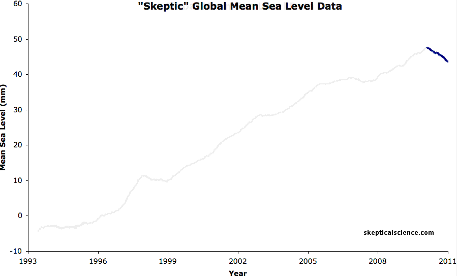
And according to you graph, sea levels have fluctuated slightly from year to year, but have risen relatively steadily over the years that the graph covers. So, what was your point exactly?
Willis said that while 2010 began with a sizable El Niño, by year’s end, it was replaced by one of the strongest La Niñas in recent memory. This sudden shift in the Pacific changed rainfall patterns all across the globe, bringing massive floods to places like Australia and the Amazon basin, and drought to the southern United States.
Data from the NASA/German Aerospace Center’s twin Gravity Recovery and Climate Experiment (Grace) spacecraft provide a clear picture of how this extra rain piled onto the continents in the early parts of 2011. “By detecting where water is on the continents, Grace shows us how water moves around the planet,” says Steve Nerem, a sea level scientist at the University of Colorado in Boulder.
So where does all that extra water in Brazil and Australia come from? You guessed it–the ocean. Each year, huge amounts of water are evaporated from the ocean. While most of it falls right back into the ocean as rain, some of it falls over land. “This year, the continents got an extra dose of rain, so much so that global sea levels actually fell over most of the last year,” says