East Antarctica also losing ice

Old Rocks

Diamond Member
Oct 31, 2008
63,085
9,749
2,040
Portland, Ore.
The melting of Antarctica was already really bad. It just got worse. - The Washington Post

The findings about East Antarctica emerge from a new paper just out in Nature Geoscience by an international team of scientists representing the United States, Britain, France and Australia. They flew a number of research flights over the Totten Glacier of East Antarctica — the fastest-thinning sector of the world’s largest ice sheet — and took a variety of measurements to try to figure out the reasons behind its retreat. And the news wasn’t good: It appears that Totten, too, is losing ice because warm ocean water is getting underneath it.

“The idea of warm ocean water eroding the ice in West Antarctica, what we’re finding is that may well be applicable in East Antarctica as well,” saysMartin Siegert, a co-author of the study and who is based at the Grantham Institute at Imperial College London.

[Research casts alarming light on the decline of West Antarctic glaciers]

The floating ice shelf of the Totten Glacier covers an area of 90 miles by 22 miles. It it is losing an amount of ice “equivalent to 100 times the volume of Sydney Harbour every year,” notes the Australian Antarctic Division.

That’s alarming, because the glacier holds back a much more vast catchment of ice that, were its vulnerable parts to flow into the ocean, could produce a sea level rise of more than 11 feet — which is comparable to the impact from a loss of the West Antarctica ice sheet. And that’s “a conservative lower limit,” says lead study author Jamin Greenbaum, a PhD candidate at the University of Texas at Austin.

A meter of sea level rise by 2100 begins to look more conservative with every year.
 
Research casts alarming light on decline of West Antarctic glaciers - The Washington Post

Now, new evidence is causing concern that the collapse could happen faster than anyone thought. New scientific studies this week have shed light on the speed and the mechanics of West Antarctic melting, documenting an acceleration that, if it continues, could have major effects on coastal cities worldwide.

Twin papers this week show that the rate of ice loss from West Antarctica is increasing — with the acceleration particularly pronounced in the past decade — and also why this is happening: Warmer ocean waters are pushing up from below and bathing the base of the ice sheet.

Both sides now.
 
Rapid shoreward encroachment of salt marsh cordgrass in response to accelerated sea-level rise
  1. Jeffrey P. Donnelly* and
  2. Mark D. Bertness
Author Affiliations

  1. Edited by Robert T. Paine, University of Washington, Seattle, WA, and approved October 11, 2001 (received for review April 29, 2001)
  1. Abstract
  2. Full Text
  3. Authors & Info
  4. Figures
  5. Metrics
  6. Related Content
  7. PDF

Abstract
The distribution of New England salt marsh communities is intrinsically linked to the magnitude, frequency, and duration of tidal inundation. Cordgrass (Spartina alterniflora) exclusively inhabits the frequently flooded lower elevations, whereas a mosaic of marsh hay (Spartina patens), spike grass (Distichlis spicata), and black rush (Juncus gerardi) typically dominate higher elevations. Monitoring plant zonal boundaries in two New England salt marshes revealed that low-marsh cordgrass rapidly moved landward at the expense of higher-marsh species between 1995 and 1998. Plant macrofossils from sediment cores across modern plant community boundaries provided a 2,500-year record of marsh community composition and documented the migration of cordgrass into the high marsh. Isotopic dating revealed that the initiation of cordgrass migration occurred in the late 19th century and continued through the 20th century. The timing of the initiation of cordgrass migration is coincident with an acceleration in the rate of sea-level rise recorded by the New York tide gauge. These results suggest that increased flooding associated with accelerating rates of sea-level rise has stressed high-marsh communities and promoted landward migration of cordgrass. If current rates of sea-level rise continue or increase slightly over the next century, New England salt marshes will be dominated by cordgrass. If climate warming causes sea-level rise rates to increase significantly over the next century, these cordgrass-dominated marshes will likely drown, resulting in extensive losses of coastal wetlands.

Rapid shoreward encroachment of salt marsh cordgrass in response to accelerated sea-level rise
 
http://www.nature.com/nclimate/journal/v2/n12/full/nclimate1597.html?W

Hotspot of accelerated sea-level rise on the Atlantic coast of North America

Nature Climate Change

2,

884–888

(2012)

doi:10.1038/nclimate1597
Received

23 January 2012
Accepted

22 May 2012
Published online

24 June 2012
Corrected online

26 April 2013
Citation


Climate warming does not force sea-level rise (SLR) at the same rate everywhere. Rather, there are spatial variations of SLR superimposed on a global average rise. These variations are forced by dynamic processes1, 2, 3, 4, arising from circulation and variations in temperature and/or salinity, and by static equilibrium processes5, arising from mass redistributions changing gravity and the Earth’s rotation and shape. These sea-level variations form unique spatial patterns, yet there are very few observations verifying predicted patterns or fingerprints6. Here, we present evidence of recently accelerated SLR in a unique 1,000-km-long hotspot on the highly populated North American Atlantic coast north of Cape Hatteras and show that it is consistent with a modelled fingerprint of dynamic SLR. Between 1950–1979 and 1980–2009, SLR rate increases in this northeast hotspot were ~ 3–4 times higher than the global average. Modelled dynamic plus steric SLR by 2100 at New York City ranges with Intergovernmental Panel on Climate Change scenario from 36 to 51cm (ref. 3); lower emission scenarios project 24–36cm (ref. 7). Extrapolations from data herein range from 20 to 29cm. SLR superimposed on storm surge, wave run-up and set-up will increase the vulnerability of coastal cities to flooding, and beaches and wetlands to deterioration.

Booby baby, ol' girl, maybe you can claim falling sea level to go along with your global cooling bullshit.
 
Fuck you idiots. 58 million acres of trees would absorb tens of millions of tons of C02 and emit millions of tons of oxygen.

Yet what do we do with those 58 million acres?

We plant corn. Corn that is destined for ethanol plants.

Does no one see the irony in this shit?

The Ass-Fucking Farmer yet again fucks us...

in the ass.
 
Antarctica is starting to turn back into the Rain Forest that it once was.
Earth knows what she needs and more green plants absorbing the CO2 is exactly what we need.
 
Portion of Larsen Ice Shelf about to break away...
icon_omg.gif

Crack in Antarctic Larsen Shelf Grew Quickly in January
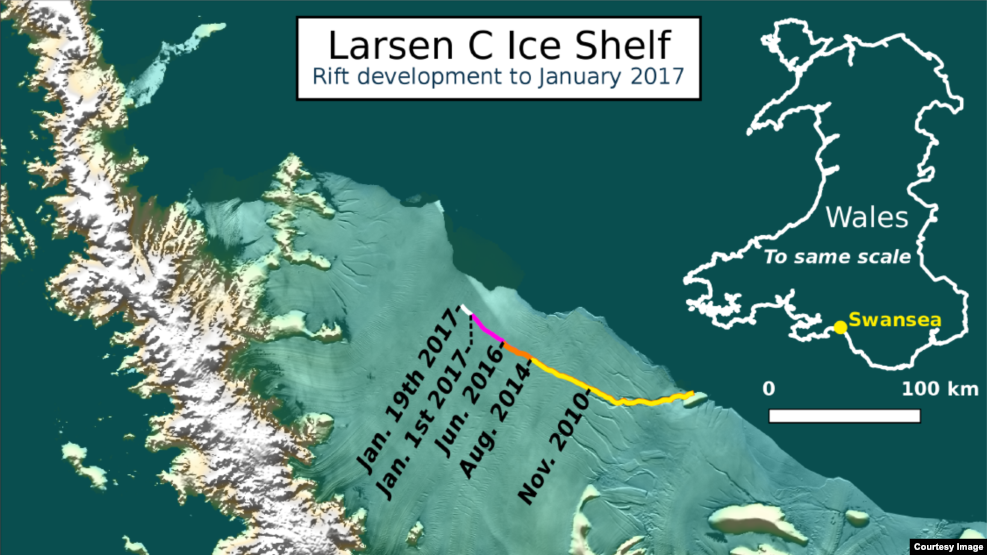
February 07, 2017 - VOA has an update on that giant crack in an Antarctic ice shelf scientists say is now sprinting towards its almost certain break from the continent. The crack is in part of the Larsen C Ice Shelf, which floats off the coast of northwestern Antarctica.
Growing, growing, gone!

Martin O'Leary is a research officer at Swansea University and a member of Project MIDAS, an Antarctic research project based in Britain. We spoke to him in early January when MIDAS announced that a crack in the Larsen C Ice Shelf had expanded by an estimated 18 kilometers in December. We spoke to him again today and he said the rate of expansion has sped up since then. He told VOA "the rift grew again in mid-January (some time between the 13th and 19th), by around 10 kilometers."

8E23CF94-796C-45C6-ADD8-08DAE1BCB320_w987_r1_s.png

The current location of the rift on Larsen C, as of January 19 2017.​

O'Leary says his team has "been monitoring this crack since around 2010, when it started to become significantly larger than the surrounding cracks. It's been of particular interest since around 2014, when it became clear that the berg was going to be a large one." By "large one," O'Leary means a chunk of ice that represents between 9 and 12 percent of the entire country-sized shelf - "around 5,000 square kilometers (about half the size of Lebanon)." Today, the only thing holding the iceberg onto the Antarctic mainland is a strip of ice about 20 kilometers long.

What is an ice shelf?

Larsen C is called an ice shelf because, while it is still attached to the land, it is already floating out at sea. The Larsen Ice Shelf is actually a series of three interconnected formations that grew out from the Antarctic Mainland over tens of thousands of years. Larsen A, the most northern of the three segments, and the smallest, broke free from the mainland in 1995.

073C416A-60DA-4B10-86D6-DC67DCFCBD04_w610_r0_s.gif

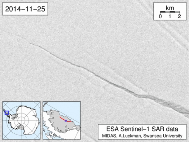
An animation of the opening of the rift, as observed by ESA's Sentinel-1 satellites​

The larger Larsen B Ice Shelf, an estimated 3,200 square kilometers of ice with an average thickness of 220 meters, disintegrated into the sea in 2002. And now Larsen C, larger still, with an ice thickness averaging 350 meters, looks to lose the next big chunk of the ice shelf. Adrian Luckman, another member of the MIDAS team, told the International Business Times, "If it doesn't go in the next few months, I'll be amazed. ... It's so close to calving that I think it's inevitable."

What happens if it goes?
 

Forum List

Back
Top