Damn, that is a lot of Ice out in the Arctic.

elektra

Platinum Member
Dec 1, 2013
23,294
10,681
915
Temecula California
The Earth is funny, it does not do what the Democrats dictate.

polarbearscience

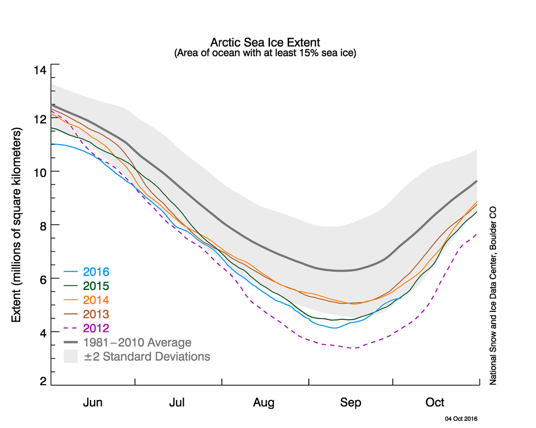
Arctic sea ice is spreading out quickly from its central basin summer refuge – according to this NSIDC Masie ice chart, it has already grown more than 2 mkm2 beyond the annual minimum reached in early September. Ice is already pushing south into the eastern Beaufort and the archipelago of Franz Josef Land in the Barents Sea.

arctic.jpg

The evidence from the last decade or so suggests that by the end of October, most of the Arctic north of the 79th parallel (see map below) will be filled with ice – although the Chukchi Sea (north of the Bering Strait) may not fill until sometime in November:
 
Run all you climate changers. The ice is coming. I guess you can't outwit the sun after all.....
The earth warms and the earth cools. And both are the sun's fault, not ours.

Now ask yourself how many trillions your president just pledged out of all of our pockets at this last "climate change" redistribution of our wealth meeting......
$44 Trillion according to CERES and the EIA
 
And a boatload of the "real" scientists out there predicted the area would be "ice free" LAST YEAR :eusa_dance::eusa_dance::up:


Who cant be convinced watching this stuff that these alarmists actually like getting kicked in the balls!! I think we are looking at social oddballs who have been conditioned over decades to being abused publically........we all remember the hopeless ones in grade school and even college.:boobies:
 
Run all you climate changers. The ice is coming. I guess you can't outwit the sun after all.....
The earth warms and the earth cools. And both are the sun's fault, not ours.

Now ask yourself how many trillions your president just pledged out of all of our pockets at this last "climate change" redistribution of our wealth meeting......


Yes........cant wait for the climate conference this year........we'll see how many scientists are thrown out like every year. If your science doesn't conform with the religion, "YOURE OUT!!!:bye1::bye1::spinner:
 
I must admit I was a little pissed off that the Ship of Fools made it through the Arctic at the last possible moment. they played Frogger all summer, using satellite data to inch along and made their final dash at buzzer. Not exactly open for navigation but they avoided the humiliation of failure by the skin of their teeth.
 
I must admit I was a little pissed off that the Ship of Fools made it through the Arctic at the last possible moment. they played Frogger all summer, using satellite data to inch along and made their final dash at buzzer. Not exactly open for navigation but they avoided the humiliation of failure by the skin of their teeth.


that's ok........big ships get stuck up in there all the time!! Love to ask the captains of those ships their opinion on global warming!!:popcorn:
 
Thanks to Melting Ice, Cruise Ship Travels Northwest Passage

85


People preparing to take a polar plunge in the Bering Sea in front of the luxury cruise ship Crystal Serenity, which anchored just outside Nome, Alaska last month. Mark Thiessen/AP

By MARK THIESSEN, Associated Press

NOME, Alaska (AP) — The giant luxury cruise liner was anchored just off Nome, too hulking to use the Bering Sea community's docks on its inaugural visit.

Instead, its more than 900 passengers piled into small transport boats and motored to shore, where they snapped photos of wild musk oxen, lifted glasses in the town's colorful bars and nibbled blueberry pie while admiring Alaska Native dancers at Nome's summer celebration.


[PHOTOS: The Real Impact of Climate Change]


The Crystal Serenity's visit to Alaska's western coast is historic. At nearly three football fields long and 13 stories tall, the cruise ship is the largest ever to traverse the Northwest Passage, where its well-heeled guests glimpsed polar bears, kayaked along Canada's north shore, landed on pristine beaches and hiked where few have stepped

Thanks to Melting Ice, Cruise Ship Travels Northwest Passage

Looks like that little sailboat was upstaged by something a bit larger.


Arctic Sea Ice News and Analysis | Sea ice data updated daily with one-day lag

The orange lines are where the ice is normally at this time of year. And note that the ice is not only well below two standard deviations from normal, it is below the amount of ice that was present at this time In the record breaking year of 2012. Not only that, but the Antarctic Sea Ice is more that two standard deviations below the norm, also.
You are a fucking liar, prove your claim Old Crock, show us the orange lines from 2005, or 2004, or 2003. If you can not give us a chart for those years, then you have shown everyone on the boards that Old Crock is a fucking liar. Go ahead, lets see all the ice charts that proves the normal.
 
Yet, despite Old Crock's proven lies, there is more ice now than in 2012, a year of a record minimum?

Since there is already more ice in the Beaufort and Chukchi Seas (at 20 October) than there was at 31 October 2007 and 2012, it looks like 2016 may show a different pattern again
 
Last edited:
But what does it all mean? Simple, the alarmists are making up what a normal year is, because the charts only go back to 2006, that is why I have demanded Old Crock to prove his assertion. I know he can't, there are no charts to show what the normal amount of Ice is, or was. The "scientists" make it up.
 
Damn Ms. Elektra, the comparison is date to date, and for this date, there is less ice than there was in 2012. As for the rest, argue with the satellite cameras.
 
Damn Ms. Elektra, the comparison is date to date, and for this date, there is less ice than there was in 2012. As for the rest, argue with the satellite cameras.
You conceded, very good Old Crock, everyone knows you are a fucking liar, when challenged, Old Crock always fails.

On a side note, it is already snowing in North Carolina!

Friday Brings First North Carolina Snow Of Season To The Region – WataugaOnline.com

Friday Brings First North Carolina Snow Of Season To The Region
October 21, 2016 6:10 pm by Kenneth Reece
 
Let us check Old Crock's link, source for fun, typically Old Crock posts things that prove Old Crock is as dumb as the come.

Here is Old Crock's link
Arctic Sea Ice News and Analysis | Sea ice data updated daily with one-day lag

This is what it says:
Since reaching its seasonal minimum on September 10 of 4.14 million square kilometers (1.60 million square miles), Arctic sea ice extent has increased at a rapid rate.

The link also says this years minimum was not in the top 4! of minimums.
 
Wow, thanks Old Crock! Great news! In 21 days Arctic Ice grew 20%! Great source Old Crock, to prove my points, mainly that Old Crock is a liar. And again, Old Crock's link specifically states the Ice grew very rapid!

Arctic Sea Ice News and Analysis | Sea ice data updated daily with one-day lag
[As of October 1, Arctic sea ice extent stood at 5.19 million square kilometers (2.00 million square miles), which is an increase of 1.05 million square kilometers (405,000 square kilometers) from the seasonal minimum of 4.14 million square kilometers (1.60 million square miles) recorded on September 10. Compared to some other years, the growth rate since the seasonal minimum has been quite rapid/QUOTE]
 

Figure 2. The graph above shows Arctic sea ice extent as of October 4, 2016, along with daily ice extent data for four previous years. 2016 is shown in blue, 2015 in green, 2014 in orange, 2013 in brown, and 2012 in purple. The 1981 to 2010 average is in dark gray. The gray area around the average line shows the two standard deviation range of the data. Sea Ice Index data.

Credit: National Snow and Ice Data Center

Looks like 2016 comes in second to 2012.
 
Thanks to Melting Ice, Cruise Ship Travels Northwest Passage

85


People preparing to take a polar plunge in the Bering Sea in front of the luxury cruise ship Crystal Serenity, which anchored just outside Nome, Alaska last month. Mark Thiessen/AP

By MARK THIESSEN, Associated Press

NOME, Alaska (AP) — The giant luxury cruise liner was anchored just off Nome, too hulking to use the Bering Sea community's docks on its inaugural visit.

Instead, its more than 900 passengers piled into small transport boats and motored to shore, where they snapped photos of wild musk oxen, lifted glasses in the town's colorful bars and nibbled blueberry pie while admiring Alaska Native dancers at Nome's summer celebration.


[PHOTOS: The Real Impact of Climate Change]


The Crystal Serenity's visit to Alaska's western coast is historic. At nearly three football fields long and 13 stories tall, the cruise ship is the largest ever to traverse the Northwest Passage, where its well-heeled guests glimpsed polar bears, kayaked along Canada's north shore, landed on pristine beaches and hiked where few have stepped

Thanks to Melting Ice, Cruise Ship Travels Northwest Passage

Looks like that little sailboat was upstaged by something a bit larger.


sweet pic!!! :rock:
 

Forum List

Back
Top