Old Rocks
Diamond Member
what parts do you consider too conservative? I have looked at the evidence and seen exaggerations everywhere.
The arctic sea ice predictions are way off. We can easily lose that summer sea ice in a couple years. The sea level predictions are also way off, but let me post June snow cover trends to show why my logic is correct.
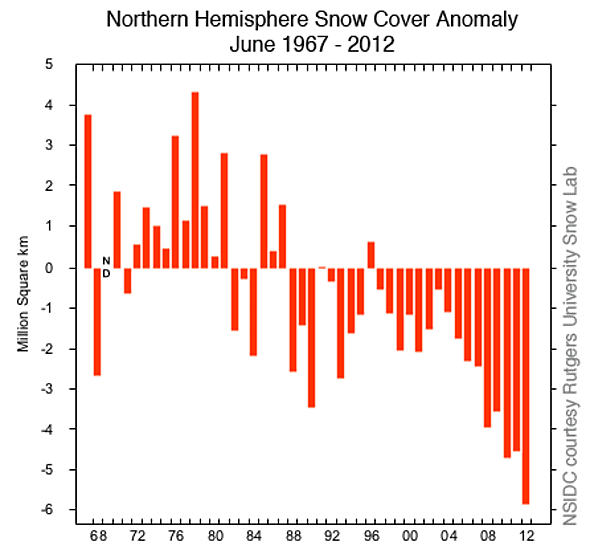
Here is a chart of June snow cover anomalies in the Northern Hemisphere. When you are down around 6 million square miles, compare that to the remaining arctic sea ice in summer and the area of Greenland! That's nearly three times the area of either one. Now, picture the wind blowing across areas that have snow or don't. Picture the sun rising and the difference of it reflecting off of snow or warming the ground without snow! That changes the temperature of the air and when that air blows over other ice covered areas, it's much warmer.
We're going to have those 150 year Greenland melts on a regular basis, unless the trend reverses and there is more white to reflect sunlight.
What is suppose to reverse that trend? I don't think wishful thinking will do it.
And yet there is no way in heck that this rendevous could occur today. Also here is a nice chart showing the vast majority of the ice loss occurred when CO2 levels were much lower and all before 1900.
Walleyes, you are going to go with this one glacier, and think that the rest of us are dumb enough to judge what is happening in the whole of the world is represented in the history of this one glacier?
You have again posted a lie. Most of the regression of the glaciers worldwide have occured in since the '50s until present. And that is the statement of the USGS and the Geological Services of the rest of the northern nations worldwide. This one tidewater glacier hardly represents the whole world.

 .....how many times are you going to try to beat that dead horse??? How many times has this BS of your been debunked????? You are such a loser retard, walleyed.....