A Cool Looking Map

The Ds and Rs are pretty much in agreement over the Syria strike. Hence, the point of my post.

The Democrats are composed of various factions, to include the neocon moderates like Hillary Clinton and her gang, along with the neoMarxist left like the Obama supporters and the democratic socialist left like Sanders. The latter two groups do not support this kind of military action in general as they tend to take anti-US perspectives on any international broohahah. The Clinton wing is definitely in favor, though and they align often with the GOP Neocons and Chicken-hawks as well like McCain and that short little kid Lindsey. In the GOP there is also open opposition like Rand Paul and other "America First" types who are against letting an Imperial Presidency develop.

So I dont think it is as simple as "The establishents of both parties are in favor of more military action in Syria."

The Democrats are being taken over by factions that lean against them, and the GOP is run by a man right now who is also a cynic and skeptic of this idea of the US as policeman of the world.

I think we should be patient with our leaders and see the larger perspective over time. Hammering Assad was a good move for his use of chemical weapons and it HAD to be done, IMO , no mater what the political Establishment may think.

Sometimes they do get lucky and get something right..
 
The fake point that land masses have votes, or that land masses have political parties, or whatever the fuck he thought he was doing before I set him straight.
The POINT is, the "blue" shrunk significantly over 8 years and "red" grew. You're losing. That's the point. See you in 2018
 
If you are a Republican.

It is a precinct level map of the USA in the 2008, 2012, and then 2016 superimposed on each other.


output_Vs1Zup.gif


2008 has the most blue, and 2016 the least blue.

Once again frothing at the mouth at the concept of "square mileage". Yes Virginia, when a county in Buttefuck Montana that is the size of Uranus and has 47 voters in it and and 11 of 'em vote for Rump, nine of 'em vote for Clinton, seven vote for McMullen and 20 of 'em said fuck it, why bother to vote at all, you get a Great Red Spot that looks like the size of Uranus. Which is nice and all if you actually think that acres vote rather than people. And perhaps when acres get the franchise that will be interesting.

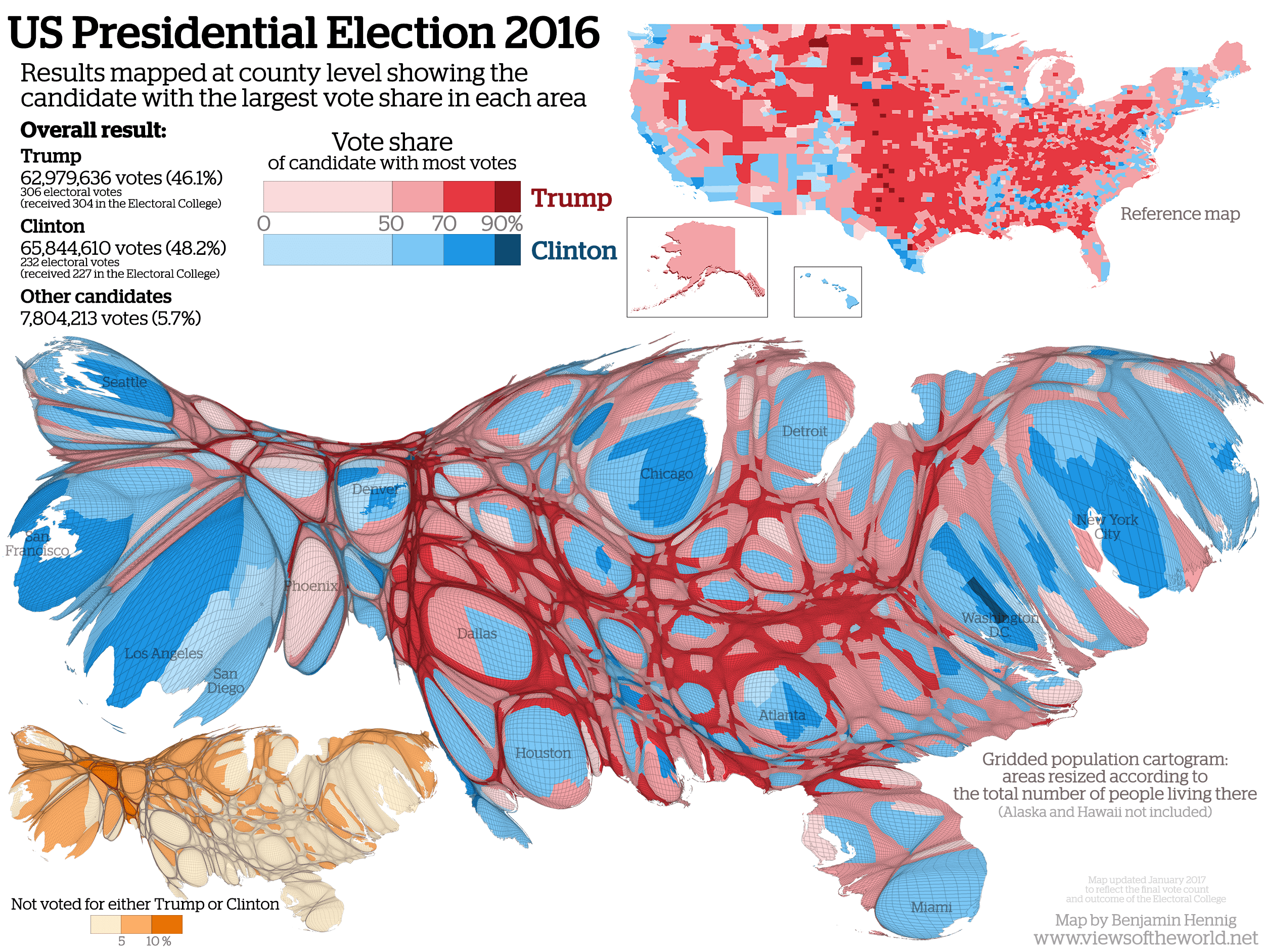
If you were to look at how actual people vote however, here's your cool map.

USelection2016Cartogram.png


A few libtards moving and retiring in Alabama from New York City does not make your map.


.its about values and morals which you obviously don't have..


.
 
A few libtards moving and retiring in Alabama from New York City does not make your map.
.its about values and morals which you obviously don't have..
.
Pogo keeps putting up that old distorted map that seems to indicate that as many people live in New York as live in San Francisco.

There is so much more blue on that stupid map that you wonder how could the Dimmocrats have lost in any state at all.

Meanwhile, so 'Hello' to President Trump!
 
If you are a Republican.

It is a precinct level map of the USA in the 2008, 2012, and then 2016 superimposed on each other.


output_Vs1Zup.gif


2008 has the most blue, and 2016 the least blue.

Once again frothing at the mouth at the concept of "square mileage". Yes Virginia, when a county in Buttefuck Montana that is the size of Uranus and has 47 voters in it and and 11 of 'em vote for Rump, nine of 'em vote for Clinton, seven vote for McMullen and 20 of 'em said fuck it, why bother to vote at all, you get a Great Red Spot that looks like the size of Uranus. Which is nice and all if you actually think that acres vote rather than people. And perhaps when acres get the franchise that will be interesting.

If you were to look at how actual people vote however, here's your cool map.

USelection2016Cartogram.png


A few libtards moving and retiring in Alabama from New York City does not make your map.


.its about values and morals which you obviously don't have..


.


people decide to retire in Alabama?
 
If you are a Republican.

It is a precinct level map of the USA in the 2008, 2012, and then 2016 superimposed on each other.


output_Vs1Zup.gif


2008 has the most blue, and 2016 the least blue.

Once again frothing at the mouth at the concept of "square mileage". Yes Virginia, when a county in Buttefuck Montana that is the size of Uranus and has 47 voters in it and and 11 of 'em vote for Rump, nine of 'em vote for Clinton, seven vote for McMullen and 20 of 'em said fuck it, why bother to vote at all, you get a Great Red Spot that looks like the size of Uranus. Which is nice and all if you actually think that acres vote rather than people. And perhaps when acres get the franchise that will be interesting.

If you were to look at how actual people vote however, here's your cool map.

USelection2016Cartogram.png

Yet, the House, the Senate, and most of the state legislatures and Governors are red.

The only conclusion is that Democrats are too stupid to find a polling place.
 
If you are a Republican.

It is a precinct level map of the USA in the 2008, 2012, and then 2016 superimposed on each other.


output_Vs1Zup.gif


2008 has the most blue, and 2016 the least blue.

Once again frothing at the mouth at the concept of "square mileage". Yes Virginia, when a county in Buttefuck Montana that is the size of Uranus and has 47 voters in it and and 11 of 'em vote for Rump, nine of 'em vote for Clinton, seven vote for McMullen and 20 of 'em said fuck it, why bother to vote at all, you get a Great Red Spot that looks like the size of Uranus. Which is nice and all if you actually think that acres vote rather than people. And perhaps when acres get the franchise that will be interesting.

If you were to look at how actual people vote however, here's your cool map.

USelection2016Cartogram.png


A few libtards moving and retiring in Alabama from New York City does not make your map.


.its about values and morals which you obviously don't have..


.

Nope. It's about voters, which means people. Not counties, not states, not electors, not land mass ---- people.

None of that in any way relates to "values and morals". Perhaps the OP's dishonesty does but hey, that's what I corrected.
 
The fake point that land masses have votes, or that land masses have political parties, or whatever the fuck he thought he was doing before I set him straight.
The POINT is, the "blue" shrunk significantly over 8 years and "red" grew. You're losing. That's the point. See you in 2018

There were no "blue" or "red" square miles to "shrink" or "grow". His entire base of reasoning is bogus.

Again for you slow kids --- land masses don't vote.
 

Forum List

Back
Top