A Cool Looking Map

Wake up folks. The Rs will do nothing different from the Ds, because after all both parties are owned by the same people.

So the chemical attacks that killed those children and the conventional bombs that were used later to kill people in the hospital being treated from the earlier attack using short range drones and fixed wing aircraft was all controlled by Establishment master minds in DC?

Dude, that is simply paranoia if you really think that.

What if the fixed wing aircraft used conventional bombs and ruptured a rebel chemical weapon stockpile?
 
LOOK! Pogo is still bitterly clinging to that PV. He must think a few million wetbacks gathered in one state should determine the outcome of an American election. LOL

LOOK! Pogo posted a map that reflects people rather than land area. Guess which one of those two entities actually votes. Go on, guess. You have a 50-50 chance of getting it right.
So, you're all for Illegals voting. I knew that already.
 
Wake up folks. The Rs will do nothing different from the Ds, because after all both parties are owned by the same people.

So the chemical attacks that killed those children and the conventional bombs that were used later to kill people in the hospital being treated from the earlier attack using short range drones and fixed wing aircraft was all controlled by Establishment master minds in DC?

Dude, that is simply paranoia if you really think that.
How do those attacks have anything to do with my post?
Well, are the missile strikes not something that the Dimmocrats are willing to do?

It shows a clear exception to your general statements.
 
Wake up folks. The Rs will do nothing different from the Ds, because after all both parties are owned by the same people.

So the chemical attacks that killed those children and the conventional bombs that were used later to kill people in the hospital being treated from the earlier attack using short range drones and fixed wing aircraft was all controlled by Establishment master minds in DC?

Dude, that is simply paranoia if you really think that.

What if the fixed wing aircraft used conventional bombs and ruptured a rebel chemical weapon stockpile?

As I understand it sarin gas and it's similar chemical family are stored in separate chemical components that get mixed just before being loaded.

Like an epoxy glue, simply smashing the container does not make it an active chemical.
 
If you are a Republican.

It is a precinct level map of the USA in the 2008, 2012, and then 2016 superimposed on each other.


output_Vs1Zup.gif


2008 has the most blue, and 2016 the least blue.

Once again frothing at the mouth at the concept of "square mileage". Yes Virginia, when a county in Buttefuck Montana that is the size of Uranus and has 47 voters in it and and 11 of 'em vote for Rump, nine of 'em vote for Clinton, seven vote for McMullen and 20 of 'em said fuck it, why bother to vote at all, you get a Great Red Spot that looks like the size of Uranus. Which is nice and all if you actually think that acres vote rather than people. And perhaps when acres get the franchise that will be interesting.

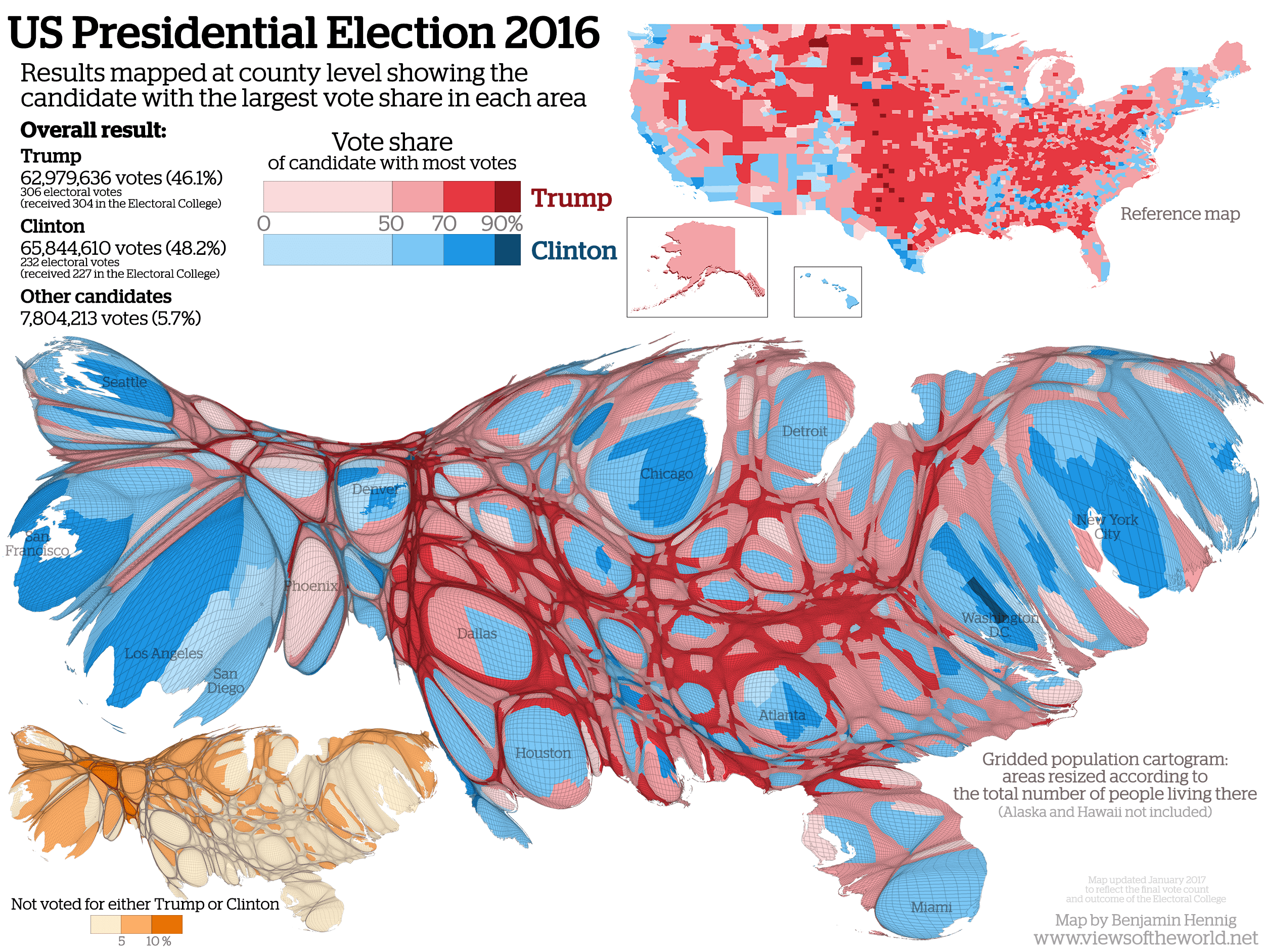
If you were to look at how actual people vote however, here's your cool map.

USelection2016Cartogram.png
That ain't no map, Pogo! It's a roadkill fish.


cartoon+fish+2.png
No....that's his lower intestine.
 
If you are a Republican.

It is a precinct level map of the USA in the 2008, 2012, and then 2016 superimposed on each other.


output_Vs1Zup.gif


2008 has the most blue, and 2016 the least blue.

Once again frothing at the mouth at the concept of "square mileage". Yes Virginia, when a county in Buttefuck Montana that is the size of Uranus and has 47 voters in it and and 11 of 'em vote for Rump, nine of 'em vote for Clinton, seven vote for McMullen and 20 of 'em said fuck it, why bother to vote at all, you get a Great Red Spot that looks like the size of Uranus. Which is nice and all if you actually think that acres vote rather than people. And perhaps when acres get the franchise that will be interesting.

If you were to look at how actual people vote however, here's your cool map.

USelection2016Cartogram.png
The founders considered prorating vote worth against property ownership.

We however do not.

Nor does the OP's map reflect that, it's just land mass, a lot of which is federal or even corporate (see northwest Maine). None of that votes.
 
If you are a Republican.

It is a precinct level map of the USA in the 2008, 2012, and then 2016 superimposed on each other.


output_Vs1Zup.gif


2008 has the most blue, and 2016 the least blue.

Once again frothing at the mouth at the concept of "square mileage". Yes Virginia, when a county in Buttefuck Montana that is the size of Uranus and has 47 voters in it and and 11 of 'em vote for Rump, nine of 'em vote for Clinton, seven vote for McMullen and 20 of 'em said fuck it, why bother to vote at all, you get a Great Red Spot that looks like the size of Uranus. Which is nice and all if you actually think that acres vote rather than people. And perhaps when acres get the franchise that will be interesting.

If you were to look at how actual people vote however, here's your cool map.

USelection2016Cartogram.png
The founders considered prorating vote worth against property ownership.
Isnt it funny how libtards can only make their points by DISTORTING THINGS LIKE MAPS?

That's called a "cartogram", not a "map".

"Maps" show land mass. "Cartograms" show voting.

You really shouldn't call yourself a "libtard". You don't rate the first name.
 
Wake up folks. The Rs will do nothing different from the Ds, because after all both parties are owned by the same people.

So the chemical attacks that killed those children and the conventional bombs that were used later to kill people in the hospital being treated from the earlier attack using short range drones and fixed wing aircraft was all controlled by Establishment master minds in DC?

Dude, that is simply paranoia if you really think that.
How do those attacks have anything to do with my post?
Well, are the missile strikes not something that the Dimmocrats are willing to do?

It shows a clear exception to your general statements.
The Ds and Rs are pretty much in agreement over the Syria strike. Hence, the point of my post.
 
If you are a Republican.

It is a precinct level map of the USA in the 2008, 2012, and then 2016 superimposed on each other.


output_Vs1Zup.gif


2008 has the most blue, and 2016 the least blue.

Once again frothing at the mouth at the concept of "square mileage". Yes Virginia, when a county in Buttefuck Montana that is the size of Uranus and has 47 voters in it and and 11 of 'em vote for Rump, nine of 'em vote for Clinton, seven vote for McMullen and 20 of 'em said fuck it, why bother to vote at all, you get a Great Red Spot that looks like the size of Uranus. Which is nice and all if you actually think that acres vote rather than people. And perhaps when acres get the franchise that will be interesting.

If you were to look at how actual people vote however, here's your cool map.

USelection2016Cartogram.png
The founders considered prorating vote worth against property ownership.

We however do not.

Nor does the OP's map reflect that, it's just land mass, a lot of which is federal or even corporate (see northwest Maine). None of that votes.
The point was to avoid allowing mobs to dictate policy which is pretty much what happens with urban centers voting democrat like a large corralled flock of sheep.
 
LOOK! Pogo is still bitterly clinging to that PV. He must think a few million wetbacks gathered in one state should determine the outcome of an American election. LOL

LOOK! Pogo posted a map that reflects people rather than land area. Guess which one of those two entities actually votes. Go on, guess. You have a 50-50 chance of getting it right.
Tell that to President Hillary Clinton, stupid.
 
If you are a Republican.

It is a precinct level map of the USA in the 2008, 2012, and then 2016 superimposed on each other.


output_Vs1Zup.gif


2008 has the most blue, and 2016 the least blue.

Once again frothing at the mouth at the concept of "square mileage". Yes Virginia, when a county in Buttefuck Montana that is the size of Uranus and has 47 voters in it and and 11 of 'em vote for Rump, nine of 'em vote for Clinton, seven vote for McMullen and 20 of 'em said fuck it, why bother to vote at all, you get a Great Red Spot that looks like the size of Uranus. Which is nice and all if you actually think that acres vote rather than people. And perhaps when acres get the franchise that will be interesting.

If you were to look at how actual people vote however, here's your cool map.

USelection2016Cartogram.png
The founders considered prorating vote worth against property ownership.
Isnt it funny how libtards can only make their points by DISTORTING THINGS LIKE MAPS?

That's called a "cartogram", not a "map".

"Maps" show land mass. "Cartograms" show voting.

You really shouldn't call yourself a "libtard". You don't rate the first name.
We know what it is. You have so much butthurt from losing you distort the election results to make yourself feel better.
 
If you are a Republican.

It is a precinct level map of the USA in the 2008, 2012, and then 2016 superimposed on each other.


output_Vs1Zup.gif


2008 has the most blue, and 2016 the least blue.

Once again frothing at the mouth at the concept of "square mileage". Yes Virginia, when a county in Buttefuck Montana that is the size of Uranus and has 47 voters in it and and 11 of 'em vote for Rump, nine of 'em vote for Clinton, seven vote for McMullen and 20 of 'em said fuck it, why bother to vote at all, you get a Great Red Spot that looks like the size of Uranus. Which is nice and all if you actually think that acres vote rather than people. And perhaps when acres get the franchise that will be interesting.

If you were to look at how actual people vote however, here's your cool map.

USelection2016Cartogram.png
The founders considered prorating vote worth against property ownership.

We however do not.

Nor does the OP's map reflect that, it's just land mass, a lot of which is federal or even corporate (see northwest Maine). None of that votes.
The point was to avoid allowing mobs to dictate policy which is pretty much what happens with urban centers voting democrat like a large corralled flock of sheep.

Nope. Only a dictator can dictate policy. By definition. On the other side of that same definition coin is the fact that when the side you didn't vote for wins influence, that does not make them a "dictator".

What we have above is a corrected representation of how that process we call the "vote" actually went down. What the OP would have had us believe is that some voter living in a low population density-per-square mile counts way way way way way way way more than a voter living in a higher one. Which is a fantasy, which is why I popped that there balloon.

That about it?
 
LOOK! Pogo is still bitterly clinging to that PV. He must think a few million wetbacks gathered in one state should determine the outcome of an American election. LOL

LOOK! Pogo posted a map that reflects people rather than land area. Guess which one of those two entities actually votes. Go on, guess. You have a 50-50 chance of getting it right.
Tell that to President Hillary Clinton, stupid.

Don't need to, stupid. I already posted to the tard that actually tried to make the fake point.
 
If you are a Republican.

It is a precinct level map of the USA in the 2008, 2012, and then 2016 superimposed on each other.


output_Vs1Zup.gif


2008 has the most blue, and 2016 the least blue.

Once again frothing at the mouth at the concept of "square mileage". Yes Virginia, when a county in Buttefuck Montana that is the size of Uranus and has 47 voters in it and and 11 of 'em vote for Rump, nine of 'em vote for Clinton, seven vote for McMullen and 20 of 'em said fuck it, why bother to vote at all, you get a Great Red Spot that looks like the size of Uranus. Which is nice and all if you actually think that acres vote rather than people. And perhaps when acres get the franchise that will be interesting.

If you were to look at how actual people vote however, here's your cool map.

USelection2016Cartogram.png
The founders considered prorating vote worth against property ownership.
Isnt it funny how libtards can only make their points by DISTORTING THINGS LIKE MAPS?

That's called a "cartogram", not a "map".

"Maps" show land mass. "Cartograms" show voting.

You really shouldn't call yourself a "libtard". You don't rate the first name.
We know what it is. You have so much butthurt from losing you distort the election results to make yourself feel better.

Actual, that's exactly what the OP tried to do.
Not to worry --- I fixed it. Thank me later.
 
LOOK! Pogo is still bitterly clinging to that PV. He must think a few million wetbacks gathered in one state should determine the outcome of an American election. LOL

LOOK! Pogo posted a map that reflects people rather than land area. Guess which one of those two entities actually votes. Go on, guess. You have a 50-50 chance of getting it right.
Tell that to President Hillary Clinton, stupid.

Don't need to, stupid. I already posted to the tard that actually tried to make the fake point.
The fake point? Like Hillary winning the election?

I don't believe the OP even mentioned any "Hillary".
The fake point that land masses have votes, or that land masses have political parties, or whatever the fuck he thought he was doing before I set him straight.
 
If you are a Republican.

It is a precinct level map of the USA in the 2008, 2012, and then 2016 superimposed on each other.


output_Vs1Zup.gif


2008 has the most blue, and 2016 the least blue.

Once again frothing at the mouth at the concept of "square mileage". Yes Virginia, when a county in Buttefuck Montana that is the size of Uranus and has 47 voters in it and and 11 of 'em vote for Rump, nine of 'em vote for Clinton, seven vote for McMullen and 20 of 'em said fuck it, why bother to vote at all, you get a Great Red Spot that looks like the size of Uranus. Which is nice and all if you actually think that acres vote rather than people. And perhaps when acres get the franchise that will be interesting.

If you were to look at how actual people vote however, here's your cool map.

USelection2016Cartogram.png
The founders considered prorating vote worth against property ownership.

We however do not.

Nor does the OP's map reflect that, it's just land mass, a lot of which is federal or even corporate (see northwest Maine). None of that votes.
The point was to avoid allowing mobs to dictate policy which is pretty much what happens with urban centers voting democrat like a large corralled flock of sheep.

Nope. Only a dictator can dictate policy. By definition. On the other side of that same definition coin is the fact that when the side you didn't vote for wins influence, that does not make them a "dictator".

What we have above is a corrected representation of how that process we call the "vote" actually went down. What the OP would have had us believe is that some voter living in a low population density-per-square mile counts way way way way way way way more than a voter living in a higher one. Which is a fantasy, which is why I popped that there balloon.

That about it?
Mob rule is a collective dictator.
You are trying to justify that and I countered with the opposite concept. The ultimate decision is a result of a combination which is exactly how Trump won.
 

Forum List

Back
Top