5 major disasters (not Yellowstone or Long Valley) always about to do the US:

bobgnote

Rookie
Nov 24, 2008
1,258
38
0
5 Natural Disasters Headed for the United States

40-Mile-Long Mudslide, Washington State
Movin' Mountain, Mt.Ranier

On an overcast afternoon high on Mount Rainier, a rocky slope slumps and then cuts loose from the mountain. Small rock slides are common on the volcano's steep flanks, but this one is different. Most of Mount Rainier's west face is in motion. Into the tumbling maelstrom go millions of tons of ice from the Puyallup and Tahoma glaciers. House-size rocks disintegrate in the downward crush. “With Rainier's active hydrothermal system saturating the rock, the landslide would reach the base of the slope as a flowing mass of watery, muddy debris,” says Kevin Scott, scientist emeritus at the U.S. Geological Survey's Cascade Volcano Observatory (CVO).

So a lahar is born--a volcanic mudflow--and a nightmare realized for the approximately 150,000 Washington residents who live and work on the solidified debris of past flows. The mass of roiling mud, rock and trees, traveling at 60 mph, would quickly funnel into the canyons of the Puyallup and Carbon rivers, where it would rise 180 ft. high before spreading into the lowlands as a 15-ft. wave.

The USGS gives a 1-in-7 chance of a similar event occurring in anyone's lifetime. And, says Dan Dzurisin, a CVO geologist: “There's no guarantee there would be any advance warning.”


80-Ft.-High Tsunami, Atlantic Coast
Coast Buster

Cumbre Vieja, the most active volcano in the Canary Islands, lurches as a violent earthquake wracks its upper slopes. A third of the mountain breaks away and plunges into the Atlantic Ocean, pushing up a dome of water nearly 3000 ft. high. They don't yet know it, but tens of millions of Americans from Key West, Fla., to South Lubec, Maine, have just 9 hours to escape with their lives.

The collapse of Cumbre Vieja unleashes a train of enormous waves traveling at jetliner speed. The first slam into nearby islands, then the African mainland. By the time they reach the East Coast of North America, the waves are up to 80 ft. high, and in low-lying areas, sweep several miles inland.

When tsunamis strike the United States, it is usually Hawaii or Alaska that take the hit. But topography and population density put the East Coast in a special risk category. “More Easterners are exposed to potential tsunamis--from the Canary Islands or the Cape Verde Islands--than the people on the West Coast, which has a steep coastline and few lowlands,” says Steven Ward, a geophysicist at the University of California, Santa Cruz. A Cumbre Vieja eruption in 1949 opened a mile-long, 20-ft.-deep fissure near the crest, forcing the volcano's western face to slump several feet. A 1971 eruption didn't budge it.

Marine geologists at Southampton Oceanography Center in Great Britain have a different take. They conclude the volcano would collapse in stages-- at worst threatening nearby islands. Ward calculates only a 5 percent chance Cumbre Vieja will trigger a tsunami in a given century, but that when it does a chunk of earth 15 miles long, 9 miles wide and nearly 1 mile thick will plunge into the sea--a landslide 250 times larger than the collapse of Mount St. Helens.


PM2.gif

The tsunami's probable trajectory within 5 hours of the collapse of Cumbre Vieja.

PM3.gif

The tsunami's potential range of destruction 9 hours after the collapse of Cumbre Vieja


-----------

This last event is happening, already, to cause aggravated sea level rise, between Cape Hatteras and Boston. Next?
 
Last edited by a moderator:
nature can dish out a handful & then some, yes she can. Go down to Miami and say "Andrew" & people still get chills.
 
10/17/89 Santa Cruz Quake, was very tough on me and mine. Looped St Helens back in Sept 80, during a minor eruption. Did not get anywhere close though. The fallout was a bitch.
 
Now THIS to me is seriously scary stuff to get a bit anxious about...............espsically since Im a stone's throw from the ocean here on Long Island, so Im basically fucked because there is not way to get out of this place except via a couple of bridges.
 
  • Thread starter
  • Banned
  • #8
It has been known for awhile, how high tides may affect magma chambers, to cause volcanoes to erupt:

Tidal Lunacy

More than 25 years ago, a pair of earth scientists compared the records for 680 eruptions that occurred since 1900 and found that "the probability of an eruption is greatest at times of maximum tidal amplitude." In plainer language, volcanoes are more likely to erupt at the fortnightly (or 14-day) "high" tide.

A specific look at 52 Hawaiian eruptions since January 1832 shows the same sort of pattern. "Nearly twice as many eruptions have occurred nearer fortnightly tidal maximum than tidal minimum." HVO scientists have noted that the Pu'u 'O'o fountaining episodes each occurred remarkably close to fortnightly tidal maximums and that the first set of eruption pauses in 1990 (periods where the eruption turned off for up to a few days) occurred remarkably close to fortnightly tidal minimums.

--------------------------

If you want to check out tides:

http://www.bim-icet.org/

--------------------------

CVO Website - Learn About Volcanoes

--------------------------

HVO Volcano Watch

--------------------------

Cumbre Vieja is NOT on the list of volcanoes, in the Cascades or in Hawaii, which the USGS monitors, to forward data, to their websites.

I wonder why the fuck not? CV is going to pop the East Coast, Greenland, Brazil, the Caribbean, etc. So why not get out the word, on what is coming, from the Canary Islands?

CV will be the worst fuckover, before Yellowstone blows.

The Long Valley eruption will be nasty, but it will only be a zit, compared to CV or Yellowstone. If Yosemite goes off, AND a lot of rain falls on Sacto, the KJ and his crowd in Sacto might notice.

One more disaster, coming: one fine La Nina, too much rain will fall, in the Sacramento area and in the Sierras, and the levees holding back Sacramento Delta and river water will fail, since they are complete crap, made by farmers, since the turn of the 19th to the 20th Century.

When that hard rain falls, and those levees fail, the Kings will be a swim-team.
 
  • Thread starter
  • Banned
  • #9
Even WORSE, an El Nino wet can really raid Sacto. But downtown Sacto has been flooded, by a La Nina event. Now that those levees are old, we are one earthquake and one hard rain away, from complete and total ruin, in Central California.
 
And then you have the inevitable 9 to 9.5 quake on the subduction zone that is below Northern California, Oregon, Washington, and Vancouver Island. It will be a very interesting quake. Will it give way all at once, or do an enechelone series, maybe starting at the southern end. That quake will damage or destroy virtually every bridge and overpass from Cape Mendicino to Vancouver Island. It will create tsunamis in some places with a runup as high as 500 ft.

If it happens in my lifetime, I hope I have retired to Eastern Oregon by that time.
 
That subduction-related event would be the famous "Purple Earthquake." Watch out, for the Huskies.
 
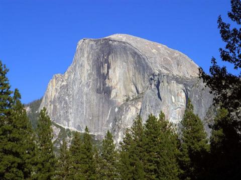
See this?

Yosemite.jpg


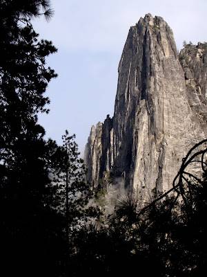
And this?

DSC03530+Sentinel+Rock.jpg


El Capitan is also a big old volcano, supposedly extinct. But Half-Dome is swelling.

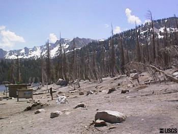
And Long Valley is getting stinky, with areas of dead forest, killed by the noxious gasses, emitted by the rising plume:


USGS: Volcano Hazards Program - Long Valley Caldera Monitoring: Gas Monitoring at Long Valley and the Surrounding Region

Between 1988 and 1989 a large amount of CO2 was detected near the edge of Long Valley Caldera at Mammoth Mountain; the event also coincided with an earthquake swarm. The gas discharge has been responsible for a large kill-off of vegetation in the area.


img174_350w_263h.jpg


USGS: Volcano Hazards Program California Volcano Observatory


USGS: Volcano Hazards Program Activity Updates for California Volcano Observatory


Rising sea level could change any of these situations, from "normal," to something else.
 
i was at mount Saint helens in 1998 it was still bare from the blast when the volcano erupted. i still remember watching the footage from the disaster in Washington State.
 
Is the Big One about to happen?...
:eek:
300 tremors hit Southern California
Aug. 26,`12 (UPI) -- Southern California's Imperial County was shaken throughout the day Sunday by a swarm of about 300 earthquakes up to a 5.5-magnitude, seismologists said.
The equivalent of an "earthquake storm" caused cosmetic damage to at least three older buildings in downtown Brawley, Capt. Jesse Zendejas of the Brawley Fire Department said. No injuries were reported, the Los Angeles Times said.

Seismologist Rob Graves with the U.S. Geological Survey said such flurries of mostly minor temblors are not unprecedented in the region, with the last one also occurring in the Brawley area in 2005.

Graves said the cause of swarm earthquakes is not fully known, but he noted the Brawley area is situated between known active earthquake faults, including the Imperial and San Andreas faults.

Brawley resident Alfonso Alvarez, 28, said the multiple quakes led him and his family to leave their house. "It's been pretty bad. Some of them are slow and then they get intense," he said. "We're so anxious right now we can't sit still." USGS seismologist Lucy Jones said the swarm could last for days.

Source

See also:

East Coast earthquake created a 'new normal'
August 23, 2012, — When the "Big One" rocked the East Coast one year ago, the earthquake centered on this rural Virginia town cracked ceiling tiles and damaged two local school buildings so badly that they had to be shuttered for good. Now as the academic year gets under way, students are reciting a new safety mantra: Drop, cover, and hold on.
Earthquake drills are now as ubiquitous as fire drills at Louisa County schools in central Virginia, where 4,600 students were attending classes when the 5.8-magnitude quake struck nearby on Aug. 23, 2011. Miraculously, no one was seriously hurt. "It's the new normal," Superintendent Deborah D. Pettit said of the earthquake drills. "It's become a normal part of the school routine and safety." One such drill is planned for Thursday at 1:51 p.m. EDT — the precise moment a year ago when the quake struck.

The unexpected jolt cracked the Washington Monument in spots and toppled delicate masonry high atop the National Cathedral. The shaking was felt far along the densely populated Eastern seaboard from Georgia to New England. While West Coast earthquake veterans scoffed at what they viewed as only a moderate temblor, last year's quake has changed the way officials along the East Coast view emergency preparedness. Emergency response plans that once focused on hurricanes, tornadoes, flooding and snow are being revised to include quakes. Some states have enacted laws specifically related to the quake, and there is anecdotal evidence of a spike in insurance coverage for earthquake damage.

The quake was centered 3 to 4 miles beneath Mineral, a town of fewer than 500 people about 50 miles northwest of Richmond. Yet it was believed to have been felt by more people than any other in U.S. history. The damage, estimated at more than $200 million, extended far beyond rural Louisa County. In the nation's capital, the Washington Monument sustained several large cracks and remains closed indefinitely. The National Park Service plans next month to finalize the contract to repair the Washington Monument. Repairs are expected to cost $15 million and require a massive scaffolding, and the landmark obelisk is likely to remain closed until 2014.

The National Cathedral reopened last November, but repairs are expected to take years and cost $20 million. The cathedral announced Thursday that it has received a $5 million grant from the Indianapolis-based Lilly Endowment Inc. With that funding in place, stonemasons were scheduled to begin active restoration Thursday afternoon. Previously, they had been stabilizing the damaged components and cataloging the damage.

More http://online.wsj.com/article/APd2774bcc165a41e98e62b0f8480437cb.html
 
Last edited:
Clue to super volcanic eruption...
:confused:
Scientists see volcanic eruption 'trigger'
Oct. 12 (UPI) -- British scientists say they have identified a repeating underground trigger for the largest explosive volcanic eruptions on Earth.
Researchers from the University of Southampton have been studying the Las Canadas volcanic caldera on Tenerife in the Canary Islands, which has generated at least eight major eruptions during the last 700,000 years. These catastrophic events have created eruption columns more than 15 miles high and thrown gas and ash over 80 miles away from the volcano, they said.

In an analysis of igneous rocks discovered in pyroclastic deposits of major eruptions, the scientists found pre-eruptive mixing within the magma chamber of older cooler magma with younger hotter magma appears to be the repeating trigger in large-scale eruptions, a Southampton release said Friday.

The analysis showed signs of major mixing events in the magma chamber immediately before eruption, they said. "Stirring young hot magma into older, cooler magma appears to be a common event before these explosive eruptions," researcher Rex Taylor said.

The Las Canadas volcano is considered worthy of particular study in light of its history of large, destructive eruptions and its proximity to populated areas, the researchers said.

Read more: Scientists see volcanic eruption 'trigger' - UPI.com
 
See this?

Yosemite.jpg


And this?

DSC03530+Sentinel+Rock.jpg


El Capitan is also a big old volcano, supposedly extinct. But Half-Dome is swelling.

And Long Valley is getting stinky, with areas of dead forest, killed by the noxious gasses, emitted by the rising plume:


USGS: Volcano Hazards Program - Long Valley Caldera Monitoring: Gas Monitoring at Long Valley and the Surrounding Region

Between 1988 and 1989 a large amount of CO2 was detected near the edge of Long Valley Caldera at Mammoth Mountain; the event also coincided with an earthquake swarm. The gas discharge has been responsible for a large kill-off of vegetation in the area.


img174_350w_263h.jpg


USGS: Volcano Hazards Program California Volcano Observatory


USGS: Volcano Hazards Program Activity Updates for California Volcano Observatory


Rising sea level could change any of these situations, from "normal," to something else.


El Cap and Half Dome are NOT VOLCANO'S! Jeezus keeerist, they are part of the Sierra Nevada Batholith and are quartz monzonite. They look the way they do because the valley was comprehensively scoured by glaciers.
 

Forum List

Back
Top